FAA INFORMATION EFFECTIVE 14 MAY 2026
Location
| FAA Identifier: | NY18 |
| Lat/Long: | 42-26-55.2610N 076-37-00.8050W
42-26.921017N 076-37.013417W
42.4486836,-76.6168903
(estimated) |
| Elevation: | 1283 ft. / 391.1 m (surveyed) |
| Variation: | 11W (1985) |
| From city: | 5 miles W of ITHACA, NY |
| Time zone: | UTC -4 (UTC -5 during Standard Time) |
| Zip code: | 14850 |
Airport Operations
| Airport use: | Private use. Permission required prior to landing |
| Activation date: | 06/1981 |
| Control tower: | no |
| ARTCC: | NEW YORK CENTER |
| FSS: | BUFFALO FLIGHT SERVICE STATION |
| Attendance: | MON-FRI 0800-1700 |
| Wind indicator: | yes |
| Segmented circle: | yes |
Airport Communications
| WX AWOS-3PT at ITH (7 nm E): | 125.175 (607-697-7959) |
| WX AWOS-3 at N03 (20 nm NE): | 132.225 (607-753-9784) |
Nearby radio navigation aids
| VOR radial/distance | | VOR name | | Freq | | Var |
|---|
| CFBr319/27.6 | | BINGHAMTON VOR/DME | | 112.20 | | 10W |
| NDB name | | Hdg/Dist | | Freq | | Var | | ID |
|---|
| ALPINE | | 039/14.2 | | 245 | | 12W | | ALP | .- .-.. .--. |
Airport Services
Runway Information
Runway 9/27
| Dimensions: | 2400 x 50 ft. / 732 x 15 m |
| Surface: | turf, in fair condition |
| RUNWAY 9 | | RUNWAY 27 |
| Traffic pattern: | left | | left |
| Obstructions: | 30 ft. trees, 50 ft. from runway, 50 ft. right of centerline, 1:1 slope to clear | | 70 ft. trees, 140 ft. from runway, 90 ft. right of centerline, 2:1 slope to clear |
Runway 18/36
| Dimensions: | 2100 x 75 ft. / 640 x 23 m |
| Surface: | turf, in fair condition |
| RUNWAY 18 | | RUNWAY 36 |
| Traffic pattern: | right | | left |
| Obstructions: | 25 ft. pline, marked, 90 ft. from runway, 3:1 slope to clear | | 10 ft. trees, 30 ft. from runway, 40 ft. left of centerline, 3:1 slope to clear |
Airport Ownership and Management from official FAA records
| Ownership: | Privately-owned |
| Owner: | RICHARD J NENO, SR.
1965 MECKLENBERG RD
ITHACA, NY 14850
Phone 607-272-6261 |
| Manager: | RICHARD J NENO, SR.
1965 MECKLENBERG RD
ITHACA, NY 14850
Phone 607-279-7130 |
Additional Remarks
| - | RY 09/27 CLSD DURING WINTER MONTHS. |
| - | FOR CD CTC NEW YORK ARTCC AT 631-468-1425. |
Instrument Procedures
There are no published instrument procedures at NY18.
Some nearby airports with instrument procedures:
KITH - Ithaca Tompkins International Airport (7 nm E)
N03 - Cortland County Airport-Chase Field (20 nm NE)
KELM - Elmira/Corning Regional Airport (21 nm SW)
KPEO - Penn Yan/Yates County Airport (22 nm NW)
0G7 - Finger Lakes Regional Airport (27 nm N)
|
|

Road maps at:
MapQuest
Bing
Google
| Aerial photo |
|---|

|
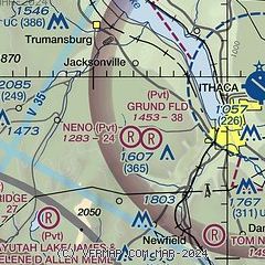
| Sectional chart |
|---|
|
| Airport distance calculator |
|---|
|
|
| Sunrise and sunset |
|---|
|
Times for 23-May-2026
| | Local
(UTC-4) | | Zulu
(UTC) |
|---|
| Morning civil twilight | | 05:05 | | 09:05 |
| Sunrise | | 05:39 | | 09:39 |
| Sunset | | 20:28 | | 00:28 |
| Evening civil twilight | | 21:01 | | 01:01 |
|
| Current date and time |
|---|
| Zulu (UTC) | 23-May-2026 19:27:41 |
|---|
| Local (UTC-4) | 23-May-2026 15:27:41 |
|---|
|
| METAR |
|---|
KITH
7nm E | 231856Z 13014G22KT 4SM RA BR BKN013 OVC026 08/07 A3039 RMK AO2 SLP296 P0014 T00830072
|
KN03
20nm NE | 231915Z AUTO 11005G15KT 4SM +RA BKN015 OVC023 08/06 A3040 RMK AO2
|
|
| TAF |
|---|
KITH
7nm E | 231744Z 2318/2418 14015G25KT P6SM -RA OVC035 TEMPO 2318/2322 2SM -RA OVC025 FM232200 15015G25KT 2SM -SHRA BR OVC010 TEMPO 2322/2324 2SM -RA OVC009 FM240000 15017KT 4SM -RA BR OVC015 WS020/15040KT FM240500 14012G22KT 4SM -SHRA BR OVC009 FM241600 15013KT 6SM BR OVC010
|
|
| NOTAMs |
|---|
NOTAMs are issued by the DoD/FAA and will open in a separate window not controlled by AirNav.
|
|

