FAA INFORMATION EFFECTIVE 14 MAY 2026
Location
| FAA Identifier: | NY25 |
| Lat/Long: | 43-05-07.0000N 076-17-33.8000W
43-05.116667N 076-17.563333W
43.0852778,-76.2927222
(estimated) |
| Elevation: | 405 ft. / 123 m (estimated) |
| Variation: | 12W (1985) |
| From city: | 4 miles N of CAMILLUS, NY |
| Time zone: | UTC -4 (UTC -5 during Standard Time) |
| Zip code: | 13164 |
Airport Operations
| Airport use: | Private use. Permission required prior to landing |
| Activation date: | 11/1988 |
| Control tower: | no |
| ARTCC: | BOSTON CENTER |
| FSS: | BUFFALO FLIGHT SERVICE STATION |
| Attendance: | UNATNDD |
| Wind indicator: | yes |
| Segmented circle: | no |
| Lights: | SS-SR |
Airport Communications
| WX ASOS at SYR (8 nm E): | PHONE 315-526-3244 |
| WX AWOS-3P at 6B9 (12 nm SW): | 120.125 (315-685-5790) |
| WX ASOS at FZY (16 nm N): | 119.275 (315-598-8773) |
Nearby radio navigation aids
| VOR radial/distance | | VOR name | | Freq | | Var |
|---|
| SYRr232/5.9 | | SYRACUSE VORTAC | | 117.00 | | 11W |
Airport Services
Runway Information
Runway 10/28
| Dimensions: | 3970 x 60 ft. / 1210 x 18 m |
| Surface: | asphalt, in fair condition |
| Runway edge lights: | non-standard
NSTD SOLAR LIGHTS WITH NSTD SPACING AND MISSING LIGHTS. |
| Runway edge markings: | FADED & IRREGULAR
FADED & IREG; ALSO WHITE MKGS NEAR SHERIFF HELIPORT ADJCT TO RY THLD SHOULD BE YELLOW. |
| RUNWAY 10 | | RUNWAY 28 |
| Traffic pattern: | left | | left |
| Markings: | NSTD, in fair condition | | NSTD, in fair condition |
| Obstructions: | 35 ft. trees, 246 ft. from runway, 1:1 slope to clear
RY 10 HAS +30-40 FT TREES, 0- 200FT FM THLD, 20-40FT LEFT & RIGHT. | | 23 ft. bldg, lighted, 208 ft. from runway, 125 ft. right of centerline
RY 28 HAS +25 FT BLDG., 123 FT RIGHT., 153 FT FM THLD; +102 FT TREES, 104 FT LEFT, 11 FT FM THLD. |
Airport Ownership and Management from official FAA records
| Ownership: | Privately-owned |
| Owner: | CAMILLUS AIRPORT, INC.
3301 CESSNA LANE
WARNERS, NY 13164
Phone (315) 487-2098 |
| Manager: | MR MIKE RUSYNIAK
CAMILLUS AIRPORT, 3301 CESSNA DRIVE
WARNERS, NY 13164
Phone 315-487-2098 |
Additional Remarks
| - | RY 10/28 TERRAIN DROPS OFF 3 TO 4 FT ALONG BOTH SIDES OF RY ON WEST END. |
| - | HELIPAD LOCATED JUST NORTHEAST OF RWY 28 THLD |
| - | RY 28 HAS 23 FT RR TRACKS PARALLEL TO RY 153 FT LEFT. |
| - | RY NOT PLOWED IN WINTER. |
| - | FOR CD CTC SYRACUSE APCH AT 315-455-6218. |
Instrument Procedures
There are no published instrument procedures at NY25.
Some nearby airports with instrument procedures:
KSYR - Syracuse Hancock International Airport (8 nm E)
B16 - Whitfords Airport (11 nm W)
6B9 - Skaneateles Aero Drome (12 nm SW)
KFZY - Oswego County Airport (16 nm N)
0G7 - Finger Lakes Regional Airport (25 nm SW)
|
|

Road maps at:
MapQuest
Bing
Google
| Aerial photo |
|---|
WARNING: Photo may not be current or correct

Do you have a better or more recent aerial photo of Camillus Airport that you would like to share? If so, please send us your photo.
|
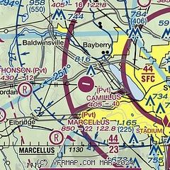
| Sectional chart |
|---|
|
| Airport distance calculator |
|---|
|
|
| Sunrise and sunset |
|---|
|
Times for 04-Jun-2026
| | Local
(UTC-4) | | Zulu
(UTC) |
|---|
| Morning civil twilight | | 04:53 | | 08:53 |
| Sunrise | | 05:28 | | 09:28 |
| Sunset | | 20:39 | | 00:39 |
| Evening civil twilight | | 21:14 | | 01:14 |
|
| Current date and time |
|---|
| Zulu (UTC) | 05-Jun-2026 00:48:04 |
|---|
| Local (UTC-4) | 04-Jun-2026 20:48:04 |
|---|
|
| METAR |
|---|
KSYR
9nm E | 042354Z 32005KT 10SM SCT200 SCT260 25/09 A3003 RMK AO2 SLP162 T02500094 10283 20250 56017
|
K6B9
12nm SW | 050035Z AUTO 00000KT CLR 20/12 A3005 RMK AO2
|
KFZY
16nm N | 042354Z AUTO 30003KT 10SM CLR 23/09 A3003 RMK AO2 SLP167 T02330089 10272 20233 56018
|
|
| TAF |
|---|
KSYR
9nm E | 041906Z 0419/0518 30008G16KT P6SM FEW250 FM051600 27004KT P6SM SCT170
|
|
| NOTAMs |
|---|
NOTAMs are issued by the DoD/FAA and will open in a separate window not controlled by AirNav.
|
|

