FAA INFORMATION EFFECTIVE 27 NOVEMBER 2025
Location
| FAA Identifier: | O47 |
| Lat/Long: | 35-28-50.8000N 096-43-07.5000W
35-28.846667N 096-43.125000W
35.4807778,-96.7187500
(estimated) |
| Elevation: | 1041 ft. / 317.3 m (surveyed) |
| Variation: | 03E (2015) |
| From city: | 2 miles W of PRAGUE, OK |
| Time zone: | UTC -6 (UTC -5 during Daylight Saving Time) |
| Zip code: | 74864 |
Airport Operations
| Airport use: | Open to the public |
| Activation date: | 08/1964 |
| Control tower: | no |
| ARTCC: | FORT WORTH CENTER |
| FSS: | MC ALESTER FLIGHT SERVICE STATION |
| NOTAMs facility: | MLC (NOTAM-D service available) |
| Attendance: | UNATNDD |
| Wind indicator: | lighted |
| Segmented circle: | yes |
| Lights: | MIRL RWY 17/35 ON SS-SR, PRESET LOW INTST. INCR INTST - CTAF. |
| Beacon: | white-green (lighted land airport)
Operates sunset to sunrise. |
Airport Communications
| CTAF: | 122.9 |
| WX AWOS-3 at SRE (13 nm S): | 118.625 (405-382-0111) |
| WX AWOS-3PT at SNL (13 nm SW): | 118.275 (405-214-1916) |
| WX AWOS-3PT at CQB (15 nm N): | 119.275 (405-258-6724) |
- APCH/DEP CTL SVC PRVDD BY FORT WORTH ARTCC (ZFW) ON FREQS 132.2/338.35 (MC ALESTER RCAG).
Nearby radio navigation aids
| NDB name | | Hdg/Dist | | Freq | | Var | | ID |
|---|
| HENRYETTA | | 274/34.8 | | 267 | | 04E | | HET | .... . - |
Airport Services
| Fuel available: | 100LL
100LL:AVBL 24 HRS CREDIT CARD ADPS. |
| Oil available: | FREQ OTS INDEFLY. |
| Parking: | tiedowns |
| Airframe service: | MAJOR |
| Powerplant service: | MAJOR |
| Bottled oxygen: | NONE |
| Bulk oxygen: | NONE |
Runway Information
Runway 17/35
| Dimensions: | 3600 x 60 ft. / 1097 x 18 m |
| Surface: | asphalt, in good condition |
| Weight bearing capacity: | |
| Runway edge lights: | medium intensity |
| RUNWAY 17 | | RUNWAY 35 |
| Latitude: | 35-29.142660N | | 35-28.549350N |
| Longitude: | 096-43.123707W | | 096-43.127112W |
| Elevation: | 1041.0 ft. | | 1010.1 ft. |
| Traffic pattern: | left | | left |
| Runway heading: | 177 magnetic, 180 true | | 357 magnetic, 000 true |
| Displaced threshold: | 110 ft. | | no |
| Markings: | nonprecision, in good condition | | nonprecision, in good condition |
| Visual slope indicator: | 2-light PAPI on left (3.00 degrees glide path) | | 2-light PAPI on left (3.00 degrees glide path) |
| Touchdown point: | yes, no lights | | yes, no lights |
| Obstructions: | 49 ft. tree, marked, 262 ft. from runway, 205 ft. right of centerline, 1:1 slope to clear
36 FT PWR LN 225 FT LEFT OF RWY CNTRLN. 15 FT ROAD AT RWY END, 185 FT LEFT AND 150 FT RIGHT OF CNTRLN. | | none
36 FT PWR LN 225 FT LEFT OF RWY CNTRLN. 15 FT ROAD AT RWY END, 185 FT RIGHT OF CNTRLN. |
Airport Ownership and Management from official FAA records
| Ownership: | Publicly-owned |
| Owner: | CITY OF PRAGUE
820 N JIM THORPE BLVD.
PRAGUE, OK 74864
Phone 405-567-2270 |
| Manager: | JIM GREFF
820 N JIM THORPE BLVD.
PRAGUE, OK 74864
Phone 405-567-2270
CITY MGR. |
Additional Remarks
| - | FOR CD CTC FORT WORTH ARTCC AT 817-858-7584. |
Instrument Procedures
NOTE: All procedures below are presented as PDF files. If you need a reader for these files, you should download the free Adobe Reader.NOT FOR NAVIGATION. Please procure official charts for flight.
FAA instrument procedures published for use from 27 November 2025 at 0901Z to 25 December 2025 at 0900Z.
IAPs - Instrument Approach Procedures |
|---|
| RNAV (GPS) RWY 17 | |
download (184KB) |
| RNAV (GPS)-A | |
download (170KB) |
| NOTE: Special Take-Off Minimums/Departure Procedures apply | |
download |
Other nearby airports with instrument procedures:
KSRE - Seminole Municipal Airport (13 nm S)
KSNL - Shawnee Regional Airport (13 nm SW)
KCQB - Chandler Regional Airport (15 nm N)
3F7 - Jones Memorial Airport (24 nm NE)
F99 - Holdenville Municipal Airport (28 nm SE)
|
|

Road maps at:
MapQuest
Bing
Google
| Aerial photo |
|---|
WARNING: Photo may not be current or correct
 Photo by L Danko
Photo taken 31-Oct-2020
looking southeast from 3500 ft msl.
Photo by L Danko
Photo taken 31-Oct-2020
looking southeast from 3500 ft msl.
Do you have a better or more recent aerial photo of Prague Municipal Airport that you would like to share? If so, please send us your photo.
|
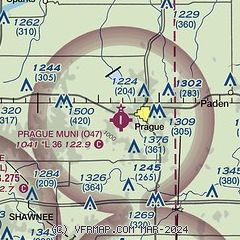
| Sectional chart |
|---|
|
| Airport distance calculator |
|---|
|
|
| Sunrise and sunset |
|---|
|
Times for 02-Dec-2025
| | Local
(UTC-6) | | Zulu
(UTC) |
|---|
| Morning civil twilight | | 06:52 | | 12:52 |
| Sunrise | | 07:20 | | 13:20 |
| Sunset | | 17:13 | | 23:13 |
| Evening civil twilight | | 17:41 | | 23:41 |
|
| Current date and time |
|---|
| Zulu (UTC) | 02-Dec-2025 20:30:56 |
|---|
| Local (UTC-6) | 02-Dec-2025 14:30:56 |
|---|
|
| METAR |
|---|
KSRE
13nm S | 022015Z AUTO 23007KT 10SM CLR 09/M07 A3002 RMK AO2
|
KSNL
14nm SW | 022015Z AUTO 19005G09KT 10SM CLR 10/M07 A3001 RMK AO2 T01021069
|
KCQB
15nm N | 021950Z AUTO 18009KT 10SM CLR 09/M05 A3002 RMK AO2 T00901046
|
|
| TAF |
|---|
KTIK
32nm W | 021800Z 0218/0324 18009KT 9999 SKC QNH3003INS BECMG 0301/0302 17010G15KT 9999 SKC QNH2989INS BECMG 0306/0307 17010G15KT 9999 SKC WS020/19045KT QNH2983INS BECMG 0312/0313 14009KT 9999 SCT150 QNH2986INS BECMG 0320/0321 02010KT 9999 BKN025 OVC030 QNH2995INS TX09/0221Z TNM01/0313Z
|
KOUN
39nm SW | 021732Z 0218/0318 20010KT P6SM SKC FM022100 20010G15KT P6SM SKC FM030000 17008KT P6SM SKC FM030600 16008KT P6SM SKC WS020/19035KT FM031400 VRB04KT P6SM SCT250
|
|
| NOTAMs |
|---|
NOTAMs are issued by the DoD/FAA and will open in a separate window not controlled by AirNav.
|
|

