FAA INFORMATION EFFECTIVE 23 JANUARY 2025
Location
| FAA Identifier: | OCF |
| Lat/Long: | 29-10-18.7564N 082-13-26.8127W
29-10.312607N 082-13.446878W
29.1718768,-82.2241146
(estimated) |
| Elevation: | 89.7 ft. / 27.3 m (surveyed) |
| Variation: | 04W (2000) |
| From city: | 4 miles W of OCALA, FL |
| Time zone: | UTC -5 (UTC -4 during Daylight Saving Time) |
| Zip code: | 34474 |
Airport Operations
| Airport use: | Open to the public |
| Activation date: | 08/1961 |
| Control tower: | yes |
| ARTCC: | JACKSONVILLE CENTER |
| FSS: | GAINESVILLE FLIGHT SERVICE STATION |
| NOTAMs facility: | OCF (NOTAM-D service available) |
| Attendance: | 0600-2100
SVC AFT HR - 352-682-3911. |
| Wind indicator: | lighted |
| Segmented circle: | yes |
| Lights: | WHEN ATCT CLSD ACTVT MALSR RWY 36; PAPI RWY 18 & 36; HIRL RWY 18/36 - CTAF. |
| Beacon: | white-green (lighted land airport)
Operates sunset to sunrise. |
| Landing fee: | no, FEE FOR ACR OPS ONLY. |
| Fire and rescue: | ARFF index A |
| Airline operations: | INDEX B UPON REQUEST; CLSD TO ACR OPS WITH MORE THAN 30 PAX SEATS EXC PPR - AMGR. |
Airport Communications
| CTAF: | 119.25 |
| ATIS: | 128.125 |
| WX AWOS-3PT: | 128.125 (352-237-8525) |
| OCALA GROUND: | 121.4 [0700-2000] |
| OCALA TOWER: | 119.25 [0700-2000] |
| JACKSONVILLE APPROACH: | 118.6 |
| JACKSONVILLE DEPARTURE: | 118.6 |
| WX AWOS-3T at X60 (17 nm NW): | 118.425 (352-528-9949) |
Nearby radio navigation aids
| VOR radial/distance | | VOR name | | Freq | | Var |
|---|
| OCF at field | | OCALA VORTAC | | 113.70 | | 00E |
| GNVr179/31.3 | | GATORS VORTAC | | 116.20 | | 04W |
Airport Services
| Fuel available: | 100LL JET-A1+ |
| Parking: | hangars and tiedowns |
| Airframe service: | MAJOR |
| Powerplant service: | MAJOR |
| Bottled oxygen: | HIGH |
| Bulk oxygen: | HIGH/LOW |
Runway Information
Runway 18/36
| Dimensions: | 7467 x 150 ft. / 2276 x 46 m |
| Surface: | asphalt/grooved, in good condition |
| Weight bearing capacity: | | Single wheel: | 111.0 | | Double wheel: | 181.0 | | Double tandem: | 328.0 |
|
| Runway edge lights: | high intensity |
| RUNWAY 18 | | RUNWAY 36 |
| Latitude: | 29-10.729363N | | 29-09.497208N |
| Longitude: | 082-13.383650W | | 082-13.382032W |
| Elevation: | 80.1 ft. | | 78.0 ft. |
| Traffic pattern: | left | | left |
| Runway heading: | 184 magnetic, 180 true | | 004 magnetic, 360 true |
| Displaced threshold: | 160 ft. | | 561 ft. |
| Declared distances: | TORA:7467 TODA:7467 ASDA:6717 LDA:6557 | | TORA:7195 TODA:7195 ASDA:6907 LDA:6347 |
| Markings: | precision, in fair condition | | precision, in fair condition |
| Visual slope indicator: | 4-light PAPI on left (3.00 degrees glide path) | | 4-light PAPI on left (3.00 degrees glide path) |
| Approach lights: | | | MALSR: 1,400 foot medium intensity approach lighting system with runway alignment indicator lights |
| Touchdown point: | yes, no lights | | yes, no lights |
| Instrument approach: | | | ILS |
| Obstructions: | 60 ft. trees, 2600 ft. from runway, 530 ft. right of centerline, 40:1 slope to clear | | 46 ft. tree, 2530 ft. from runway, 410 ft. right of centerline |
Runway 8/26
| Dimensions: | 3009 x 50 ft. / 917 x 15 m |
| Surface: | asphalt, in good condition |
| Weight bearing capacity: | |
| Operational restrictions: | RWY 8/26 NOT AVBL FOR SKED ACR OPNS WITH MORE THAN 9 PAX SEATS OR UNSKED ACR AT LEAST 31 PAX SEATS. |
| RUNWAY 8 | | RUNWAY 26 |
| Latitude: | 29-10.763863N | | 29-10.850597N |
| Longitude: | 082-13.884353W | | 082-13.327232W |
| Elevation: | 86.9 ft. | | 87.8 ft. |
| Traffic pattern: | left | | left |
| Runway heading: | 084 magnetic, 080 true | | 264 magnetic, 260 true |
| Markings: | basic, in fair condition | | basic, in fair condition |
| Touchdown point: | yes, no lights | | yes, no lights |
| Obstructions: | 50 ft. trees, 1205 ft. from runway, 105 ft. left of centerline, 20:1 slope to clear | | 25 ft. pline, 1045 ft. from runway, 170 ft. left of centerline, 34:1 slope to clear |
Airport Ownership and Management from official FAA records
| Ownership: | Publicly-owned |
| Owner: | CITY OF OCALA
1770 SW 60TH AVENUE, SUITE 600
OCALA, FL 34474
Phone 352-629-8377 |
| Manager: | MATTHEW GROW
1770 SW 60TH AVE, SUITE 600
OCALA, FL 34474
Phone 352-629-8377 |
Additional Remarks
| A39-18/36 | PCR VALUE: 450/F/A/X/T |
| A39-08/26 | PCR VALUE: 280/F/A/X/T |
| A30A-36 | CALM WIND RWY. |
| - | TWY A1 RSTRD TO ACFT WITH WINGSPAN 60 FT OR LESS. |
| - | OBJECT 2.5 FT AGL LCTD 39 FT NORTH OF TWY A1 CNTRLN. |
| - | RWY 36 RTHL NOT STD. |
| - | RWY 18/36 REDL NOT STD. |
| - | RWY 18 RENL NOT STD. |
| - | RWY 18/36 SAFETY AREA NONSTD IRG SFC FM ONGOING WILDLIFE BURROW MITIGATATION. |
| - | RWY 08/26 SAFETY AREA NONSTD IREG SFC FM ONGOING WILDLIFE BURROW MITIGATATION. |
| - | ACFT DEP RWY 18 MNTN RWY HDG TO 800 FT AGL OR TIL RCHG END OF RWY WHICHEVER OCRS LTR BFR MAKING LEFT TURNS. |
| - | TWY A1, A8, A9 & A12 E OF TWY A; TWY A NORTH OF TWY A2; CLSD TO ACR. |
| - | CUSTOM SVC UNAVBL. |
| - | SFC CONDS NOT RPRTD 1700-0700L. |
| - | FOR CD IF UNA TO CTC ON FSS FREQ, CTC JACKSONVILLE APCH AT 904-741-0284. |
Instrument Procedures
NOTE: All procedures below are presented as PDF files. If you need a reader for these files, you should download the free Adobe Reader.NOT FOR NAVIGATION. Please procure official charts for flight.
FAA instrument procedures published for use from 23 January 2025 at 0901Z to 20 February 2025 at 0900z.
IAPs - Instrument Approach Procedures |
|---|
| ILS OR LOC RWY 36 | |
download (272KB) |
| RNAV (GPS) RWY 18 | |
download (263KB) |
| RNAV (GPS) RWY 36 | |
download (288KB) |
| VOR RWY 36 | |
download (188KB) |
| NOTE: Special Alternate Minimums apply | |
download (148KB) |
| NOTE: Special Take-Off Minimums/Departure Procedures apply | |
download (405KB) |
Other nearby airports with instrument procedures:
X35 - Marion County Airport (10 nm SW)
X60 - Williston Municipal Airport (17 nm NW)
KINF - Inverness Airport (23 nm S)
KCGC - Crystal River Airport-Captain Tom Davis Field (26 nm SW)
KLEE - Leesburg International Airport (30 nm SE)
|
|

Road maps at:
MapQuest
Bing
Google
| Aerial photo |
|---|
WARNING: Photo may not be current or correct
 Photo by Jim Russell
Photo taken 19-Jun-2018
looking west.
Photo by Jim Russell
Photo taken 19-Jun-2018
looking west.
Do you have a better or more recent aerial photo of Ocala International Airport-Jim Taylor Field that you would like to share? If so, please send us your photo.
|
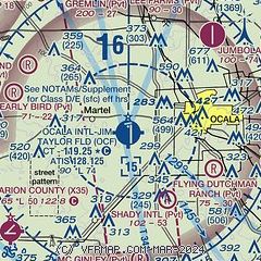
| Sectional chart |
|---|
|
CAUTION: Diagram may not be current

| Airport distance calculator |
|---|
|
|
| Sunrise and sunset |
|---|
|
Times for 07-Feb-2025
| | Local
(UTC-5) | | Zulu
(UTC) |
|---|
| Morning civil twilight | | 06:51 | | 11:51 |
| Sunrise | | 07:15 | | 12:15 |
| Sunset | | 18:11 | | 23:11 |
| Evening civil twilight | | 18:36 | | 23:36 |
|
| Current date and time |
|---|
| Zulu (UTC) | 07-Feb-2025 19:08:34 |
|---|
| Local (UTC-5) | 07-Feb-2025 14:08:34 |
|---|
|
| METAR |
|---|
| KOCF | 071851Z 00000KT 10SM FEW029 24/16 A3017 RMK AO2 SLP217 T02390161
|
KX60
17nm NW | 118.425 352-528-9949
071855Z AUTO 32009KT 10SM CLR 24/16 A3017 RMK AO2 T02420155
|
|
| TAF |
|---|
KLEE
30nm SE | 071723Z 0718/0818 25005KT P6SM SKC FM072300 VRB05KT P6SM SKC FM080900 VRB03KT 3SM BR BKN010 TEMPO 0809/0812 1SM BR BKN004 FM081500 18006KT P6SM SKC
|
KGNV
32nm N | 071723Z 0718/0818 26006KT P6SM BKN025 FM071900 26005KT P6SM SCT030 FM080400 VRB02KT 3SM BR BKN005 FM080600 VRB02KT 1/4SM FG OVC001 FM081400 20004KT 3SM BR OVC005 FM081500 20007KT P6SM SCT010
|
|
| NOTAMs |
|---|
NOTAMs are issued by the DoD/FAA and will open in a separate window not controlled by AirNav.
|
|


