FAA INFORMATION EFFECTIVE 02 OCTOBER 2025
Location
| FAA Identifier: | X60 |
| Lat/Long: | 29-21-16.5780N 082-28-14.0290W
29-21.276300N 082-28.233817W
29.3546050,-82.4705636
(estimated) |
| Elevation: | 75.6 ft. / 23.0 m (surveyed) |
| Variation: | 04W (2000) |
| From city: | 2 miles SW of WILLISTON, FL |
| Time zone: | UTC -4 (UTC -5 during Standard Time) |
| Zip code: | 32696 |
Airport Operations
| Airport use: | Open to the public |
| Activation date: | 02/1944 |
| Control tower: | no |
| ARTCC: | JACKSONVILLE CENTER |
| FSS: | GAINESVILLE FLIGHT SERVICE STATION |
| NOTAMs facility: | GNV (NOTAM-D service available) |
| Attendance: | 0730-1730 |
| Wind indicator: | lighted |
| Segmented circle: | yes |
| Lights: | ACTVT REIL RWY 05, 14, 23 & 32; HIRL RWY 05/23; MIRL RWY 14/32. - CTAF. |
| Beacon: | white-green (lighted land airport)
Operates sunset to sunrise. |
Airport Communications
| CTAF/UNICOM: | 122.975 |
| WX AWOS-3T: | 118.425 (352-528-9949) |
| JACKSONVILLE APPROACH: | 118.6 |
| JACKSONVILLE DEPARTURE: | 118.6 |
| WX AWOS-3PT at OCF (17 nm SE): | 128.125 (352-237-8525) |
Nearby radio navigation aids
| VOR radial/distance | | VOR name | | Freq | | Var |
|---|
| OCFr310/16.6 | | OCALA VORTAC | | 113.70 | | 00E |
| GNVr211/22.7 | | GATORS VORTAC | | 116.20 | | 04W |
Airport Services
| Fuel available: | 100LL JET-A |
| Parking: | hangars and tiedowns |
| Airframe service: | MAJOR |
| Powerplant service: | MAJOR |
| Bottled oxygen: | NONE |
| Bulk oxygen: | NONE |
Runway Information
Runway 5/23
| Dimensions: | 6669 x 100 ft. / 2033 x 30 m |
| Surface: | concrete/wired/combed, in good condition |
| Weight bearing capacity: | | PCN 15 /R/B/X/T | | Single wheel: | 72.0 | | Double wheel: | 95.0 | | Double tandem: | 160.0 |
|
| Runway edge lights: | high intensity |
| RUNWAY 5 | | RUNWAY 23 |
| Latitude: | 29-21.154018N | | 29-21.933342N |
| Longitude: | 082-28.592965W | | 082-27.706287W |
| Elevation: | 73.0 ft. | | 75.6 ft. |
| Traffic pattern: | left | | left |
| Runway heading: | 049 magnetic, 045 true | | 229 magnetic, 225 true |
| Markings: | nonprecision, in fair condition | | nonprecision, in fair condition |
| Visual slope indicator: | 2-light PAPI on left (3.00 degrees glide path) | | 2-light PAPI on left (3.00 degrees glide path) |
| Runway end identifier lights: | yes | | yes |
| Touchdown point: | yes, no lights | | yes, no lights |
| Obstructions: | 46 ft. trees, 1785 ft. from runway, 180 ft. left of centerline, 34:1 slope to clear | | 48 ft. trees, 1920 ft. from runway, 240 ft. right of centerline, 35:1 slope to clear |
Runway 14/32
| Dimensions: | 4979 x 60 ft. / 1518 x 18 m |
| Surface: | asphalt, in good condition |
| Weight bearing capacity: | | PCN 18 /R/A/W/T | | Single wheel: | 38.0 |
|
| Runway edge lights: | medium intensity |
| RUNWAY 14 | | RUNWAY 32 |
| Latitude: | 29-21.343833N | | 29-20.728833N |
| Longitude: | 082-28.841167W | | 082-28.219500W |
| Elevation: | 66.8 ft. | | 64.0 ft. |
| Traffic pattern: | left | | left |
| Runway heading: | 142 magnetic, 138 true | | 322 magnetic, 318 true |
| Markings: | basic, in fair condition | | basic, in fair condition |
| Visual slope indicator: | 2-light PAPI on left (3.00 degrees glide path) | | 2-light PAPI on left (3.00 degrees glide path) |
| Runway end identifier lights: | yes | | yes |
| Touchdown point: | yes, no lights | | yes, no lights |
| Obstructions: | 81 ft. trees, 1885 ft. from runway, 120 ft. right of centerline, 20:1 slope to clear
RWY 32 APRCH SLOPE 20:1 TO AER. | | 50 ft. trees, 1005 ft. from runway, 125 ft. left of centerline, 16:1 slope to clear |
Runway 18/36
| Dimensions: | 2051 x 60 ft. / 625 x 18 m |
| Surface: | turf, in fair condition |
| Runway edge markings: | RWY 18/36 MARKED WITH W TIRES. |
| RUNWAY 18 | | RUNWAY 36 |
| Latitude: | 29-21.158667N | | 29-20.820167N |
| Longitude: | 082-27.787833W | | 082-27.787833W |
| Elevation: | 65.0 ft. | | 66.0 ft. |
| Traffic pattern: | right | | left |
| Runway heading: | 184 magnetic, 180 true | | 004 magnetic, 360 true |
| Markings: | none, in fair condition | | none, in fair condition |
| Touchdown point: | yes, no lights | | yes, no lights |
| Obstructions: | 88 ft. trees, 3050 ft. from runway, 125 ft. right of centerline, 34:1 slope to clear | | 66 ft. trees, 1505 ft. from runway, 145 ft. left of centerline, 22:1 slope to clear |
Airport Ownership and Management from official FAA records
| Ownership: | Publicly-owned |
| Owner: | CITY OF WILLISTON
PO BOX 160
WILLISTON, FL 32696
Phone 352-528-3060 |
| Manager: | BENTON STEGALL
1891 SW 18TH ST
WILLISTON, FL 32696-0160
Phone 352-266-5792 |
Additional Remarks
| - | INFIELD BERM & TREES BLOCKING VISION BTN RWY ENDS. |
| - | FOR CD CTC JACKSONVILLE APCH AT 904-741-0284. |
Instrument Procedures
NOTE: All procedures below are presented as PDF files. If you need a reader for these files, you should download the free Adobe Reader.NOT FOR NAVIGATION. Please procure official charts for flight.
FAA instrument procedures published for use from 02 October 2025 at 0901Z to 30 October 2025 at 0900z.
IAPs - Instrument Approach Procedures |
|---|
| RNAV (GPS) RWY 05 | |
download (233KB) |
| RNAV (GPS) RWY 23 | |
download (230KB) |
| NOTE: Special Take-Off Minimums/Departure Procedures apply | |
download (417KB) |
Other nearby airports with instrument procedures:
KOCF - Ocala International Airport-Jim Taylor Field (17 nm SE)
X35 - Marion County Airport (18 nm S)
KGNV - Gainesville Regional Airport (23 nm NE)
KCGC - Crystal River Airport/Davis Field (30 nm S)
KINF - Inverness Airport (34 nm S)
|
|

Road maps at:
MapQuest
Bing
Google
| Aerial photo |
|---|
WARNING: Photo may not be current or correct
 Photo by William C Harris, Gladstone, NJ
Photo taken 10-Sep-2018
looking north.
Do you have a better or more recent aerial photo of Williston Regional Airport that you would like to share? If so, please send us your photo.
|
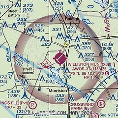
| Sectional chart |
|---|
|
| Airport distance calculator |
|---|
|
|
| Sunrise and sunset |
|---|
|
Times for 24-Oct-2025
| | Local
(UTC-4) | | Zulu
(UTC) |
|---|
| Morning civil twilight | | 07:14 | | 11:14 |
| Sunrise | | 07:38 | | 11:38 |
| Sunset | | 18:50 | | 22:50 |
| Evening civil twilight | | 19:14 | | 23:14 |
|
| Current date and time |
|---|
| Zulu (UTC) | 24-Oct-2025 14:57:55 |
|---|
| Local (UTC-4) | 24-Oct-2025 10:57:55 |
|---|
|
| METAR |
|---|
| KX60 | 118.425 352-528-9949
241255Z AUTO 03006KT 10SM CLR 15/12 A3018 RMK AO2 T01450120
|
KOCF
17nm SE | 241451Z 05007KT 020V080 10SM CLR 23/16 A3019 RMK AO2 SLP222 T02330156 51009
|
|
| TAF |
|---|
KGNV
23nm NE | 241122Z 2412/2512 VRB02KT P6SM BKN250 FM241500 06011G17KT P6SM SCT250 FM250100 VRB03KT P6SM SCT250
|
|
| NOTAMs |
|---|
NOTAMs are issued by the DoD/FAA and will open in a separate window not controlled by AirNav.
|
|


