FAA INFORMATION EFFECTIVE 22 JANUARY 2026
Location
| FAA Identifier: | OKV |
| Lat/Long: | 39-08-36.7000N 078-08-40.0000W
39-08.611667N 078-08.666667W
39.1435278,-78.1444444
(estimated) |
| Elevation: | 726.2 ft. / 221.3 m (surveyed) |
| Variation: | 10W (2000) |
| From city: | 3 miles SE of WINCHESTER, VA |
| Time zone: | UTC -5 (UTC -4 during Daylight Saving Time) |
| Zip code: | 22602 |
Airport Operations
| Airport use: | Open to the public |
| Activation date: | 11/1937 |
| Control tower: | no |
| ARTCC: | WASHINGTON CENTER |
| FSS: | LEESBURG FLIGHT SERVICE STATION |
| NOTAMs facility: | OKV (NOTAM-D service available) |
| Attendance: | 0600-2200 LCL
CALLOUT SVC AVBL. FEES MAY APPLY. |
| Pattern altitude: | TPA 1980 FT AGL FOR TURBOPROP AND JET ACFT; ALL OTHER ACFT TPA 980 FT AGL. |
| Wind indicator: | lighted |
| Segmented circle: | yes |
| Lights: | ACTVT MALSR RWY 32; REIL RWY 14; HIRL RWY 14/32 - CTAF. |
| Beacon: | white-green (lighted land airport)
Operates sunset to sunrise. |
Airport Communications
| CTAF/UNICOM: | 122.975 |
| WX AWOS-3: | 124.85 (540-662-6970) |
| POTOMAC APPROACH: | 120.45 |
| POTOMAC DEPARTURE: | 120.45 |
| CLEARANCE DELIVERY: | 126.15 |
| CLTCH DP: | 120.45 |
| HYPER STAR: | 133.0 |
| JDUBB DP: | 120.45 |
| SCRAM DP: | 120.45 |
| TRSTN STAR: | 126.75 |
| WX AWOS-3 at FRR (14 nm S): | 121.85 (540-635-5377) |
| WX ASOS at MRB (17 nm NE): | 119.925 (304-264-0988) |
Nearby radio navigation aids
| VOR radial/distance | | VOR name | | Freq | | Var |
|---|
| LDNr015/17.6 | | LINDEN VORTAC | | 114.30 | | 06W |
| MRBr230/20.0 | | MARTINSBURG VORTAC | | 112.10 | | 07W |
| CSNr343/32.8 | | CASANOVA VORTAC | | 116.30 | | 06W |
| AMLr300/34.0 | | ARMEL VOR/DME | | 113.50 | | 08W |
| HGRr209/(35.8) | | HAGERSTOWN VOR | | 109.80 | | 07W |
| FDKr254/39.2 | | FREDERICK VOR/DME | | 116.85 | | 08W |
| ESLr103/39.6 | | KESSEL VOR/DME | | 110.80 | | 06W |
| NDB name | | Hdg/Dist | | Freq | | Var | | ID |
|---|
| CAVERNS | | 039/30.7 | | 245 | | 09W | | LUA | .-.. ..- .- |
Airport Services
| Fuel available: | 100LL JET-A |
| Parking: | hangars and tiedowns |
| Airframe service: | MAJOR |
| Powerplant service: | MAJOR |
| Bottled oxygen: | NONE |
| Bulk oxygen: | NONE |
Runway Information
Runway 14/32
| Dimensions: | 5498 x 100 ft. / 1676 x 30 m |
| Surface: | asphalt/grooved, in excellent condition |
| Weight bearing capacity: | | Single wheel: | 75.0 | | Double wheel: | 150.0 |
|
| Runway edge lights: | high intensity |
| RUNWAY 14 | | RUNWAY 32 |
| Latitude: | 39-08.924787N | | 39-08.298250N |
| Longitude: | 078-09.086633W | | 078-08.246707W |
| Elevation: | 726.2 ft. | | 700.8 ft. |
| Traffic pattern: | left | | left |
| Runway heading: | 144 magnetic, 134 true | | 324 magnetic, 314 true |
| Markings: | nonprecision, in good condition | | precision, in good condition |
| Visual slope indicator: | 4-light PAPI on left (3.00 degrees glide path) | | 4-light PAPI on left (3.00 degrees glide path) |
| Approach lights: | | | MALSR: 1,400 foot medium intensity approach lighting system with runway alignment indicator lights |
| Runway end identifier lights: | yes | | |
| Touchdown point: | yes, no lights | | yes, no lights |
| Instrument approach: | | | ILS/DME |
| Obstructions: | 27 ft. tree, 664 ft. from runway, 490 ft. left of centerline, 17:1 slope to clear | | 60 ft. tree, 1986 ft. from runway, 736 ft. left of centerline, 29:1 slope to clear |
Airport Ownership and Management from official FAA records
| Ownership: | Publicly-owned |
| Owner: | WINCHESTER REG ARPT AUTH
491 AIRPORT RD
WINCHESTER, VA 22602
Phone 540-662-5786 |
| Manager: | NICK SABO
491 AIRPORT RD
WINCHESTER, VA 22602
Phone 540-662-5786 |
Additional Remarks
| - | ADCUS AVBL 24 HRS MIN ADVN NOTICE RQRD CALL 804-661-3660 MON-FRI; AFT HRS AND WKENDS CALL 703-661-3632. |
| - | DEER ON & INVOF ARPT. |
| - | MED-FLIGHT: IREG DEP PAT. |
| - | FOR CD CTC POTOMAC APCH AT 866-709-4993. |
Instrument Procedures
NOTE: All procedures below are presented as PDF files. If you need a reader for these files, you should download the free Adobe Reader.NOT FOR NAVIGATION. Please procure official charts for flight.
FAA instrument procedures published for use from 22 January 2026 at 0901Z to 19 February 2026 at 0900z.
STARs - Standard Terminal Arrivals |
|---|
| HYPER NINE (RNAV) | |
2 pages:
[1] [2] (381KB) |
| HYPER NINE (RNAV), CONT.2 | |
download (164KB) |
| TRSTN FOUR (RNAV) | |
2 pages:
[1] [2] (317KB) |
IAPs - Instrument Approach Procedures |
|---|
| ILS OR LOC RWY 32 | |
download (298KB) |
| RNAV (GPS) RWY 14 | |
download (243KB) |
| RNAV (GPS) RWY 32 | |
download (290KB) |
| VOR/DME-A | |
download (207KB) |
| NOTE: Special Alternate Minimums apply | |
download (37KB) |
Departure Procedures |
|---|
| CLTCH THREE (RNAV) | |
download (182KB) |
| JDUBB FOUR (RNAV) | |
download (205KB) |
| SCRAM SIX (RNAV) | |
download (174KB) |
| NOTE: Special Take-Off Minimums/Departure Procedures apply | |
download (360KB) |
Other nearby airports with instrument procedures:
9VA5 - Bluegrass Heliport (13 nm E)
KFRR - Front Royal-Warren County Airport (14 nm S)
KMRB - Eastern WV Regional Airport/Shepherd Field (17 nm NE)
KJYO - Leesburg Executive Airport (28 nm E)
W35 - Potomac Airpark (33 nm N)
|
|

Road maps at:
MapQuest
Bing
Google
| Aerial photo |
|---|
WARNING: Photo may not be current or correct
 Photo by David Newcomer
Photo taken 25-Nov-2017
from 6,500' looking north.
Photo by David Newcomer
Photo taken 25-Nov-2017
from 6,500' looking north.
Do you have a better or more recent aerial photo of Winchester Regional Airport that you would like to share? If so, please send us your photo.
|
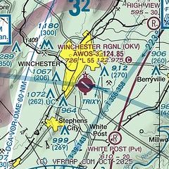
| Sectional chart |
|---|
|
CAUTION: Diagram may not be current

| Airport distance calculator |
|---|
|
|
| Sunrise and sunset |
|---|
|
Times for 15-Feb-2026
| | Local
(UTC-5) | | Zulu
(UTC) |
|---|
| Morning civil twilight | | 06:38 | | 11:38 |
| Sunrise | | 07:05 | | 12:05 |
| Sunset | | 17:48 | | 22:48 |
| Evening civil twilight | | 18:16 | | 23:16 |
|
| Current date and time |
|---|
| Zulu (UTC) | 15-Feb-2026 08:44:38 |
|---|
| Local (UTC-5) | 15-Feb-2026 03:44:38 |
|---|
|
| METAR |
|---|
| KOKV | 150835Z AUTO 23004KT 10SM CLR 03/M02 A3002 RMK AO2
|
KFRR
14nm S | 150835Z AUTO 18005KT 10SM CLR 04/M02 A3002 RMK AO2 T00371022
|
KMRB
17nm NE | 150753Z AUTO 00000KT 10SM CLR 02/M03 A3002 RMK AO2 SLP170 T00171033 $
|
|
| TAF |
|---|
KMRB
17nm NE | 150531Z 1506/1606 19006KT P6SM OVC120 FM151400 22005KT P6SM OVC090 PROB30 1516/1518 6SM -RA OVC050 FM151800 08003KT 6SM -RA SCT010 OVC035 FM152100 05003KT 3SM -RA OVC009 FM160100 01004KT 2SM BR SCT002 OVC004
|
|
| NOTAMs |
|---|
NOTAMs are issued by the DoD/FAA and will open in a separate window not controlled by AirNav.
|
|


