FAA INFORMATION EFFECTIVE 15 MAY 2025
Location
| FAA Identifier: | OXI |
| Lat/Long: | 41-19-46.9230N 086-39-52.5940W
41-19.782050N 086-39.876567W
41.3297008,-86.6646094
(estimated) |
| Elevation: | 685.3 ft. / 208.9 m (surveyed) |
| Variation: | 01W (1980) |
| From city: | 3 miles NW of KNOX, IN |
| Time zone: | UTC -5 (UTC -6 during Standard Time) |
| Zip code: | 46534 |
Airport Operations
| Airport use: | Open to the public |
| Activation date: | 04/1977 |
| Control tower: | no |
| ARTCC: | CHICAGO CENTER |
| FSS: | TERRE HAUTE FLIGHT SERVICE STATION |
| NOTAMs facility: | HUF (NOTAM-D service available) |
| Attendance: | 0800-1800
UNATNDD EASTER, MEMORIAL DAY, JULY 4TH, LABOR DAY, THANKSGIVING, CHRISTMAS EVE & DAY UNLESS APREQ. |
| Wind indicator: | lighted |
| Segmented circle: | yes |
| Lights: | ACTVT REIL RWY 18 & 36 - CTAF; PAPI RWY 18 & 36 ON CONSLY. |
| Beacon: | white-green (lighted land airport)
Operates sunset to sunrise. |
Airport Communications
| CTAF/UNICOM: | 122.8 |
| WX AWOS-3: | 135.775 (574-772-2041) |
| SOUTH BEND APPROACH: | 132.05 |
| SOUTH BEND DEPARTURE: | 132.05 |
| WX AWOS-3PT at PPO (15 nm N): | 119.825 (219-326-6916) |
| WX AWOS-3 at C65 (17 nm E): | 133.025 (574-935-3854) |
| WX ASOS at VPZ (17 nm NW): | 125.875 (219-531-1770) |
- APCH/DEP SVC PRVDD BY CHICAGO ARTCC ON FREQS 135.9/314.0 (GOSHEN RCAG) WHEN SOUTH BEND APCH CTL CLSD.
Nearby radio navigation aids
| VOR radial/distance | | VOR name | | Freq | | Var |
|---|
| GIJr211/30.6 | | GIPPER VORTAC | | 115.40 | | 00E |
| GSHr248/30.9 | | GOSHEN VORTAC | | 113.70 | | 00E |
| NDB name | | Hdg/Dist | | Freq | | Var | | ID |
|---|
| SEDLY | | 129/12.0 | | 212 | | 02W | | VP | ...- .--. |
Airport Services
| Fuel available: | 100LL JET-A+ |
| Parking: | hangars and tiedowns |
Runway Information
Runway 18/36
| Dimensions: | 5001 x 75 ft. / 1524 x 23 m |
| Surface: | asphalt, in good condition |
| Weight bearing capacity: | |
| Runway edge lights: | medium intensity |
| RUNWAY 18 | | RUNWAY 36 |
| Latitude: | 41-20.186678N | | 41-19.363178N |
| Longitude: | 086-39.734912W | | 086-39.734298W |
| Elevation: | 683.3 ft. | | 685.3 ft. |
| Traffic pattern: | right | | left |
| Runway heading: | 181 magnetic, 180 true | | 001 magnetic, 360 true |
| Markings: | nonprecision, in good condition | | nonprecision, in good condition |
| Visual slope indicator: | 2-light PAPI on left (3.00 degrees glide path) | | 2-light PAPI on left (3.00 degrees glide path) |
| Runway end identifier lights: | yes | | yes |
| Touchdown point: | yes, no lights | | yes, no lights |
| Obstructions: | 10 ft. crops, 170 ft. right of centerline
10 FT CROPS 170 FT R OF RWY END | | 10 ft. crops, 160 ft. left of centerline
10 FT CROPS 160 FT L OF RWY END |
Runway 9/27
| Dimensions: | 3096 x 145 ft. / 944 x 44 m |
| Surface: | turf, in good condition |
| Runway edge markings: | DSPLCD THR MKD BY YELLOW CONES. |
| Operational restrictions: | BOUNDARY MKD BY YELLOW CONES. |
| RUNWAY 9 | | RUNWAY 27 |
| Latitude: | 41-19.795602N | | 41-19.791512N |
| Longitude: | 086-40.444050W | | 086-39.767770W |
| Elevation: | 679.9 ft. | | 681.4 ft. |
| Traffic pattern: | left | | left |
| Runway heading: | 091 magnetic, 090 true | | 271 magnetic, 270 true |
| Displaced threshold: | 285 ft. | | no |
| Touchdown point: | yes, no lights | | yes, no lights |
| Obstructions: | 10 ft. crops
APCH SLOPE 20:1 FM DSPLCD THR; 65 FT TREES 270 FT FM RWY END 100 FT L. | | 28 ft. bldg, 190 ft. left of centerline, 26:1 slope to clear |
Airport Ownership and Management from official FAA records
| Ownership: | Publicly-owned |
| Owner: | STARKE COUNTY ARPT AUTH
1795 N. 200 E.
KNOX, IN 46534
Phone 574-772-5001 |
| Manager: | PAM BEHARRY
1795 N 200 E
KNOX, IN 46534
Phone 574-772-5001 |
Additional Remarks
| - | FOR CD CTC SOUTH BEND APCH AT 574-251-2609. WHEN SOUTH BEND APCH CLSD, FOR CD CTC CHICAGO ARTCC AT 630-906-8921. |
| - | SELF SERVICE FUEL AVBL. |
Instrument Procedures
NOTE: All procedures below are presented as PDF files. If you need a reader for these files, you should download the free Adobe Reader.NOT FOR NAVIGATION. Please procure official charts for flight.
FAA instrument procedures published for use from 15 May 2025 at 0901Z to 13 June 2025 at 0900z.
IAPs - Instrument Approach Procedures |
|---|
| RNAV (GPS) RWY 18 | |
download (247KB) |
| NOTE: Special Alternate Minimums apply | |
download (145KB) |
| NOTE: Special Take-Off Minimums/Departure Procedures apply | |
download (164KB) |
Other nearby airports with instrument procedures:
KRWN - Arens Field Airport (14 nm S)
KPPO - La Porte Municipal Airport (15 nm N)
C65 - Plymouth Municipal Airport (17 nm E)
KVPZ - Porter County Regional Airport (17 nm NW)
KMGC - Michigan City Municipal Airport-Phillips Field (23 nm N)
|
|

Road maps at:
MapQuest
Bing
Google
| Aerial photo |
|---|
WARNING: Photo may not be current or correct
 Photo by AJ Coady
Photo taken 06-Apr-2012
from 5500MSL looking north.
Photo by AJ Coady
Photo taken 06-Apr-2012
from 5500MSL looking north.
Do you have a better or more recent aerial photo of Starke County Airport that you would like to share? If so, please send us your photo.
|
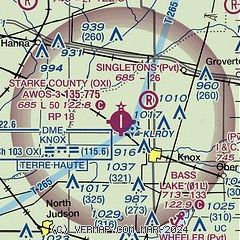
| Sectional chart |
|---|
|
CAUTION: Diagram may not be current

| Airport distance calculator |
|---|
|
|
| Sunrise and sunset |
|---|
|
Times for 28-May-2025
| | Local
(UTC-5) | | Zulu
(UTC) |
|---|
| Morning civil twilight | | 04:46 | | 09:46 |
| Sunrise | | 05:19 | | 10:19 |
| Sunset | | 20:09 | | 01:09 |
| Evening civil twilight | | 20:42 | | 01:42 |
|
| Current date and time |
|---|
| Zulu (UTC) | 28-May-2025 17:05:44 |
|---|
| Local (UTC-5) | 28-May-2025 12:05:44 |
|---|
|
| METAR |
|---|
KPPO
15nm N | 281655Z AUTO VRB03KT 7SM -RA BKN004 13/13 A3004 RMK AO2 PRESFR P0019
|
KC65
17nm E | 281655Z AUTO 08004KT 3SM BR SCT004 BKN039 BKN047 13/13 A3004 RMK A01 P0017
|
KVPZ
17nm NW | 281656Z AUTO 35003KT 10SM BKN006 OVC095 14/13 A3005 RMK AO2 RAE34 SLP175 P0005 T01390128
|
|
| TAF |
|---|
KSBN
27nm NE | 281122Z 2812/2912 08005KT P6SM SCT015 OVC060 TEMPO 2812/2816 6SM -SHRA OVC015 FM281600 06006KT 6SM -SHRA OVC012 FM290300 05007KT P6SM OVC008 FM290600 36006KT P6SM OVC005
|
|
| NOTAMs |
|---|
NOTAMs are issued by the DoD/FAA and will open in a separate window not controlled by AirNav.
|
|


