FAA INFORMATION EFFECTIVE 15 MAY 2025
Location
| FAA Identifier: | OYM |
| Lat/Long: | 41-24-44.9200N 078-30-09.4730W
41-24.748667N 078-30.157883W
41.4124778,-78.5026314
(estimated) |
| Elevation: | 1934.3 ft. / 589.6 m (surveyed) |
| Variation: | 11W (2005) |
| From city: | 3 miles SE of ST MARYS, PA |
| Time zone: | UTC -4 (UTC -5 during Standard Time) |
| Zip code: | 15857 |
Airport Operations
| Airport use: | Open to the public |
| Activation date: | 10/1946 |
| Control tower: | no |
| ARTCC: | CLEVELAND CENTER |
| FSS: | ALTOONA FLIGHT SERVICE STATION |
| NOTAMs facility: | AOO (NOTAM-D service available) |
| Attendance: | MON-FRI 0800-1600 |
| Wind indicator: | yes |
| Segmented circle: | yes |
| Lights: | ACTVT MALS RWY 28; PAPI RWYS 10 & 28; MIRL RWY 10/28 - CTAF. |
| Beacon: | white-green (lighted land airport)
Operates sunset to sunrise. |
Airport Communications
| CTAF/UNICOM: | 122.7 |
| WX AWOS-3P: | 118.05 (814-834-9416) |
- CLEARANCE DELIVERY PRVDD BY ALTOONA RADIO ON FREQ 122.4.
- APCH/DEP SVC PRVDD BY CLEVELAND ARTCC (ZOB) ON FREQS 126.725/291.65 (DUBOIS RCAG).
Nearby radio navigation aids
| VOR radial/distance | | VOR name | | Freq | | Var |
|---|
| ETGr316/20.1 | | KEATING VORTAC | | 116.00 | | 10W |
| SLTr264/24.7 | | SLATE RUN VORTAC | | 113.90 | | 08W |
| PSBr332/37.6 | | PHILIPSBURG VORTAC | | 115.50 | | 10W |
Airport Services
| Fuel available: | 100LL JET-A |
| Parking: | tiedowns |
| Airframe service: | MAJOR |
| Powerplant service: | MAJOR |
| Bottled oxygen: | NONE |
| Bulk oxygen: | NONE |
Runway Information
Runway 10/28
| Dimensions: | 4300 x 75 ft. / 1311 x 23 m |
| Surface: | asphalt/grooved, in good condition |
| Weight bearing capacity: | |
| Runway edge lights: | medium intensity |
| RUNWAY 10 | | RUNWAY 28 |
| Latitude: | 41-24.748950N | | 41-24.749117N |
| Longitude: | 078-30.628867W | | 078-29.688383W |
| Elevation: | 1902.4 ft. | | 1934.3 ft. |
| Traffic pattern: | left | | left |
| Runway heading: | 101 magnetic, 090 true | | 281 magnetic, 270 true |
| Markings: | nonprecision, in good condition | | nonprecision, in good condition |
| Visual slope indicator: | 4-light PAPI on left (3.00 degrees glide path)
PAPI UNUSBL BYD 5 DEGS RIGHT OF CNTRLN. | | 4-light PAPI on left (3.00 degrees glide path)
PAPI UNUSBL BYD 8 DEGS RIGHT OF CNTRLN. |
| Approach lights: | | | MALS: 1,400 foot medium intensity approach lighting system |
| Touchdown point: | yes, no lights | | yes, no lights |
| Instrument approach: | | | LOC/DME |
| Obstructions: | 73 ft. trees, 2354 ft. from runway, 565 ft. left of centerline, 29:1 slope to clear
+7 FT FENCE 200 FT N OF RY 0-200 FT. +15 FT PUBLIC ROAD 0-200 FT & 225 FT L. PUBLIC ROAD OBSTN MKD BY LIGHTED POLES. | | 142 ft. trees, 3734 ft. from runway, 345 ft. left of centerline, 24:1 slope to clear
+13 FT FENCE N OF RY FM 0-176 FT, 219 FT LEFT. +23 FT PUBLIC ROAD, 222 FT RIGHT. PUBLIC ROAD OBSTN MKD BY LIGHTED POLES. |
Airport Ownership and Management from official FAA records
| Ownership: | Publicly-owned |
| Owner: | CITY OF ST. MARYS
159 CESSNA ROAD
ST MARYS, PA 15857
Phone 814-834-4671 |
| Manager: | VINCE CAGGIANO
159 CESSNA RD
ST MARYS, PA 15857
Phone 814-834-4671 |
Additional Remarks
| - | FOR CD CTC CLEVELAND ARTCC AT 440-774-0234. |
| - | COLD TEMPERATURE AIRPORT. ALTITUDE CORRECTION REQUIRED AT OR BELOW -36C. |
Instrument Procedures
NOTE: All procedures below are presented as PDF files. If you need a reader for these files, you should download the free Adobe Reader.NOT FOR NAVIGATION. Please procure official charts for flight.
FAA instrument procedures published for use from 15 May 2025 at 0901Z to 13 June 2025 at 0900z.
IAPs - Instrument Approach Procedures |
|---|
| RNAV (GPS) RWY 10 | |
download (193KB) |
| RNAV (GPS) RWY 28 | |
download (220KB) |
| LOC RWY 28 | |
download (275KB) |
| VOR RWY 28 | |
download (222KB) |
| NOTE: Special Alternate Minimums apply | |
download (145KB) |
| NOTE: Special Take-Off Minimums/Departure Procedures apply | |
download (283KB) |
Other nearby airports with instrument procedures:
KFIG - Clearfield-Lawrence Airport (22 nm S)
KDUJ - Dubois Regional Airport (23 nm SW)
KBFD - Bradford Regional Airport (24 nm N)
N35 - Punxsutawney Municipal Airport (33 nm SW)
KPSB - Mid-State Airport (37 nm SE)
|
|

Road maps at:
MapQuest
Bing
Google
| Aerial photo |
|---|
WARNING: Photo may not be current or correct
 Photo by Joseph Brand
Photo taken 15-Jul-2020
looking west.
Photo by Joseph Brand
Photo taken 15-Jul-2020
looking west.
Do you have a better or more recent aerial photo of St Marys Municipal Airport that you would like to share? If so, please send us your photo.
|
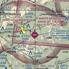
| Sectional chart |
|---|
|
| Airport distance calculator |
|---|
|
|
| Sunrise and sunset |
|---|
|
Times for 22-May-2025
| | Local
(UTC-4) | | Zulu
(UTC) |
|---|
| Morning civil twilight | | 05:18 | | 09:18 |
| Sunrise | | 05:50 | | 09:50 |
| Sunset | | 20:31 | | 00:31 |
| Evening civil twilight | | 21:04 | | 01:04 |
|
| Current date and time |
|---|
| Zulu (UTC) | 22-May-2025 17:27:58 |
|---|
| Local (UTC-4) | 22-May-2025 13:27:58 |
|---|
|
| METAR |
|---|
| KOYM | 221715Z AUTO 23006KT 10SM BKN009 BKN020 OVC036 10/09 A2973 RMK AO2 PWINO
|
|
| TAF |
|---|
KDUJ
23nm SW | 221141Z 2212/2312 22006KT 2SM -SHRA BR OVC004 FM221400 25008G18KT 2SM -SHRA OVC004 FM230300 27007KT 3SM -SHRA OVC005
|
KBFD
24nm N | 221617Z 2216/2312 21008G17KT P6SM VCSH BKN012 OVC018 FM221700 21007G15KT 4SM -SHRA BR BKN007 OVC012 FM230300 26009KT 4SM -SHRA BR BKN003 OVC005 FM230500 27009G18KT 4SM -SHRA BR OVC003
|
|
| NOTAMs |
|---|
NOTAMs are issued by the DoD/FAA and will open in a separate window not controlled by AirNav.
|
|


