FAA INFORMATION EFFECTIVE 30 OCTOBER 2025
Location
| FAA Identifier: | P15 |
| Lat/Long: | 41-49-58.5850N 079-21-38.4150W
41-49.976417N 079-21.640250W
41.8329403,-79.3606708
(estimated) |
| Elevation: | 1230 ft. / 375 m (estimated) |
| Variation: | 09W (1985) |
| From city: | 1 mile E of PITTSFIELD, PA |
| Time zone: | UTC -5 (UTC -4 during Daylight Saving Time) |
| Zip code: | 16340 |
Airport Operations
| Airport use: | Open to the public |
| Activation date: | 04/1971 |
| Control tower: | no |
| ARTCC: | CLEVELAND CENTER |
| FSS: | ALTOONA FLIGHT SERVICE STATION |
| NOTAMs facility: | AOO (NOTAM-D service available) |
| Attendance: | DAYLIGHT HOURS |
| Wind indicator: | lighted |
| Segmented circle: | yes |
| Lights: | ACTVT LIRL RY 09/27 - 122.8. |
| Beacon: | white-green (lighted land airport)
FOR ROTG BCN CALL 814-563-3166 OR 4949. |
Airport Communications
| CTAF: | 122.9 |
| WX AWOS-3PT at JHW (20 nm N): | 118.425 (716-664-6005) |
Nearby radio navigation aids
| VOR radial/distance | | VOR name | | Freq | | Var |
|---|
| JHWr214/23.9 | | JAMESTOWN VOR/DME | | 114.70 | | 07W |
| FKLr049/(32.5) | | FRANKLIN VOR | | 109.60 | | 06W |
Airport Services
| Fuel available: | 100LL |
| Parking: | hangars and tiedowns |
| Airframe service: | MINOR |
| Powerplant service: | MINOR |
| Bottled oxygen: | NONE |
| Bulk oxygen: | NONE |
Runway Information
Runway 9/27
| Dimensions: | 3650 x 100 ft. / 1113 x 30 m |
| Surface: | turf, in good condition |
| Runway edge lights: | low intensity |
| Runway edge markings: | RWY 09/27 MKD WITH YELLOW CONES & LGTS. |
| RUNWAY 9 | | RUNWAY 27 |
| Latitude: | 41-49.892333N | | 41-50.060500N |
| Longitude: | 079-22.026333W | | 079-21.254167W |
| Elevation: | 1230.0 ft. | | 1226.0 ft. |
| Traffic pattern: | left | | right |
| Runway heading: | 082 magnetic, 073 true | | 262 magnetic, 253 true |
| Displaced threshold: | 510 ft. | | 685 ft. |
| Markings: | NSTD, in good condition | | NSTD, in good condition |
| Touchdown point: | yes, no lights | | yes, no lights |
| Obstructions: | 42 ft. pole, 591 ft. from runway, 181 ft. right of centerline, 14:1 slope to clear
RY 09 APCH SLOPE 20:1 TO DSPLCD THR. | | 45 ft. trees, 526 ft. from runway, 42 ft. right of centerline, 11:1 slope to clear
RY 27 APCH SLOPE 20:1 TO DSPLCD THR. |
Airport Ownership and Management from official FAA records
| Ownership: | Privately-owned |
| Owner: | BILL HOLDER
PO BOX 134
PITTSFIELD, PA 16340
Phone 814-563-4949 |
| Manager: | BILL HOLDER
PO BOX 134
PITTSFIELD, PA 16340
Phone 814-563-3166 |
Additional Remarks
| - | 42 FT PLINE PARALLELING RY APPRX 215 FT S OF RY CNTRLN; PLINE MARKED WITH ORANGE SPHERES. |
| - | RY SOFT DURING SPRING THAW. |
| - | DEER & GEESE ON & INVOF RY. |
| - | EXTENSIVE GLIDER OPNS WEEKENDS. |
| - | RY 09 520 FT TERRAIN 2400 FT SOUTH; RY 27 370 FT TERRAIN 3600 FT EAST. |
| - | RAPIDLY RISING TERRAIN SOUTH OF THE AIRPORT. |
| - | FOR CD CTC BUFFALO APCH AT 716-626-6920, WHEN APCH CLSD CTC CLEVELAND ARTCC AT 440-774-0232. |
| - | RWY NOT MNTND DURG WINT MONTHS |
Instrument Procedures
There are no published instrument procedures at P15.
Some nearby airports with instrument procedures:
8G2 - Corry-Lawrence Airport (13 nm W)
KJHW - Chautauqua County/Jamestown Airport (20 nm N)
6G1 - Titusville Airport (22 nm SW)
KBFD - Bradford Regional Airport (32 nm E)
KFKL - Venango Regional Airport (35 nm SW)
|
|

Road maps at:
MapQuest
Bing
Google
| Aerial photo |
|---|
WARNING: Photo may not be current or correct

Do you have a better or more recent aerial photo of Brokenstraw Airport that you would like to share? If so, please send us your photo.
|
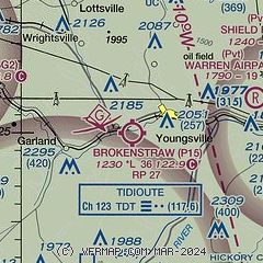
| Sectional chart |
|---|
|
| Airport distance calculator |
|---|
|
|
| Sunrise and sunset |
|---|
|
Times for 16-Nov-2025
| | Local
(UTC-5) | | Zulu
(UTC) |
|---|
| Morning civil twilight | | 06:39 | | 11:39 |
| Sunrise | | 07:09 | | 12:09 |
| Sunset | | 16:55 | | 21:55 |
| Evening civil twilight | | 17:25 | | 22:25 |
|
| Current date and time |
|---|
| Zulu (UTC) | 16-Nov-2025 21:33:34 |
|---|
| Local (UTC-5) | 16-Nov-2025 16:33:34 |
|---|
|
| METAR |
|---|
KJHW
19nm N | 162113Z AUTO 32024G37KT 3/4SM -SN FEW008 BKN026 OVC060 00/M03 A2959 RMK AO2 PK WND 30037/2105 VIS 1/4V5 RAB01E03SNB03 P0000 FZRANO RVRNO
|
|
| TAF |
|---|
KJHW
19nm N | 161722Z 1618/1718 30020G37KT 3SM -SHSN OVC025 TEMPO 1619/1623 2SM -SN BKN015 FM162300 30018G35KT 1SM -SN BLSN OVC015 FM170500 30016G27KT 1SM -SN OVC012 FM170900 31014G24KT 2SM -SHSN OVC020 FM171400 30013G22KT 4SM -SHSN BKN020
|
|
| NOTAMs |
|---|
NOTAMs are issued by the DoD/FAA and will open in a separate window not controlled by AirNav.
|
|

