FAA INFORMATION EFFECTIVE 25 DECEMBER 2025
Location
| FAA Identifier: | IYS |
| Lat/Long: | 61-34-19.1501N 149-32-22.4041W
61-34.319168N 149-32.373402W
61.5719861,-149.5395567
(estimated) |
| Elevation: | 353.7 ft. / 107.8 m (surveyed) |
| Variation: | 18E (2015) |
| From city: | 3 miles W of WASILLA, AK |
| Time zone: | UTC -9 (UTC -8 during Daylight Saving Time) |
| Zip code: | 99654 |
Airport Operations
| Airport use: | Open to the public |
| Activation date: | 05/1992 |
| Control tower: | no |
| ARTCC: | ANCHORAGE CENTER |
| FSS: | KENAI FLIGHT SERVICE STATION [907-283-7211] |
| NOTAMs facility: | IYS (NOTAM-D service available) |
| Attendance: | UNATNDD |
| Wind indicator: | lighted |
| Segmented circle: | yes |
| Lights: | ACTVT REIL RWY 04 & 22; PAPI RWY 04; MIRL RWY 04/22 - CTAF. |
| Beacon: | white-green (lighted land airport)
Operates sunset to sunrise. |
Airport Communications
| CTAF: | 122.8 |
| WX AWOS-3P: | 135.25 (907-373-3801) |
| ANCHORAGE APPROACH: | 119.1 |
| ANCHORAGE DEPARTURE: | 119.1 |
| CLASS C: | 119.1 |
| WX AWOS-3P at BCV (9 nm S): | 135.55 (907-621-7605) |
| WX ASOS at PAQ (13 nm E): | 134.75 (907-746-6675) |
| WX ASOS at FRN (19 nm S): | 134.25 |
Nearby radio navigation aids
| VOR radial/distance | | VOR name | | Freq | | Var |
|---|
| BGQr070/12.2 | | BIG LAKE VORTAC | | 112.50 | | 19E |
| TEDr009/27.1 | | ANCHORAGE VOR/DME | | 113.15 | | 18E |
Airport Services
| Fuel available: | 100LL JET-A |
| Airframe service: | MAJOR |
| Powerplant service: | MAJOR |
Runway Information
Runway 4/22
| Dimensions: | 3700 x 75 ft. / 1128 x 23 m |
| Surface: | asphalt, in good condition |
| Runway edge lights: | medium intensity |
| Runway edge markings: | NSTD MKGS; MKD WITH THLD PANELS. |
| RUNWAY 4 | | RUNWAY 22 |
| Latitude: | 61-34.130810N | | 61-34.468325N |
| Longitude: | 149-32.947373W | | 149-31.888712W |
| Elevation: | 336.1 ft. | | 353.5 ft. |
| Traffic pattern: | right | | left |
| Runway heading: | 038 magnetic, 056 true | | 218 magnetic, 236 true |
| Markings: | NSTD, in fair condition | | NSTD, in fair condition |
| Visual slope indicator: | 4-light PAPI on right (3.00 degrees glide path) | | |
| Runway end identifier lights: | yes | | yes |
| Touchdown point: | yes, no lights | | yes, no lights |
| Obstructions: | 30 ft. trees, 201 ft. from runway, 115 ft. right of centerline
BRUSH UP TO 3 FT TALL. | | 14 ft. trees, 260 ft. from runway, 120 ft. right of centerline, 4:1 slope to clear
BRUSH UP TO 3 FT TALL |
Runway 4S/22S
| Dimensions: | 1690 x 60 ft. / 515 x 18 m |
| Surface: | turf/gravel, in good condition |
| Runway edge markings: | RYS 04S & 22S NSTD MKGS; MKD WITH CONES & REFLECTIVE THLD MARKERS. |
| RUNWAY 4S | | RUNWAY 22S |
| Latitude: | 61-34.285000N | | 61-34.439167N |
| Longitude: | 149-32.517500W | | 149-32.033833W |
| Elevation: | 345.5 ft. | | 351.6 ft. |
| Traffic pattern: | left | | left |
| Runway heading: | 038 magnetic, 056 true | | 218 magnetic, 236 true |
| Markings: | NSTD | | NSTD |
| Obstructions: | 2 ft. hill, 65 ft. left of centerline | | none |
Airport Ownership and Management from official FAA records
| Ownership: | Publicly-owned |
| Owner: | CITY OF WASILLA
290 E HERNING AVE
WASILLA, AK 99687
Phone 907-373-9010 |
| Manager: | ERICH SCHAAL
CITY OF WASILLA, 290 E HERNING AVE
WASILLA, AK 99654
Phone 907-373-9018 |
Additional Remarks
| - | RY CONDITION NOT MONITORED RECOMMEND VISUAL INSPECTION PRIOR TO USE. |
| - | WX CAMERA AVBL ON INTERNET AT HTTPS://WEATHERCAMS.FAA.GOV |
| - | NUMEROUS PVT ARPTS AND LAKES IN VCNTY. ARPT RESTRICTED TO ACFT WITH APPROACH SPEEDS LESS THAN 121 KTS. |
| - | ULTRALIGHTS ON AND IN VICINITY OF AIRPORT. |
| - | NO SIMUL OPNS ON RY 04/22 & 04S/22S. |
| - | NO WINTER MAINT RY 04S/22S. |
| - | RY 04S/22S FOR SKI/TUNDRA TIRE EQUIPD ACFT. |
| - | SELF-SVC FUEL AVBL 24 HRS. |
Instrument Procedures
NOTE: All procedures below are presented as PDF files. If you need a reader for these files, you should download the free Adobe Reader.NOT FOR NAVIGATION. Please procure official charts for flight.
FAA instrument procedures published for use from 25 December 2025 at 0901z to 22 January 2026 at 0900z.
IAPs - Instrument Approach Procedures |
|---|
| RNAV (GPS) RWY 04 | |
download (269KB) |
| RNAV (GPS) RWY 22 | |
download (517KB) |
| NOTE: Special Alternate Minimums apply | |
download |
| NOTE: Special Take-Off Minimums/Departure Procedures apply | |
download (313KB) |
Other nearby airports with instrument procedures:
PAGQ - Big Lake Airport (8 nm W)
PAAQ - Warren "Bud" Woods Palmer Municipal Airport (13 nm E)
PAUO - Willow Airport (18 nm NW)
PAFR - Bryant Army Airfield (19 nm S)
PAED - Elmendorf Air Force Base (21 nm S)
|
|

Road maps at:
MapQuest
Bing
Google
| Aerial photo |
|---|
WARNING: Photo may not be current or correct
 Photo courtesy of DuBoisAviation.com
Photo taken 13-Jul-2012
looking east.
Photo courtesy of DuBoisAviation.com
Photo taken 13-Jul-2012
looking east.
Do you have a better or more recent aerial photo of Wasilla Airport that you would like to share? If so, please send us your photo.
|
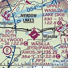
| Sectional chart |
|---|
|
| Airport distance calculator |
|---|
|
|
| Sunrise and sunset |
|---|
|
Times for 02-Jan-2026
| | Local
(UTC-9) | | Zulu
(UTC) |
|---|
| Morning civil twilight | | 09:14 | | 18:14 |
| Sunrise | | 10:17 | | 19:17 |
| Sunset | | 15:48 | | 00:48 |
| Evening civil twilight | | 16:50 | | 01:50 |
|
| Current date and time |
|---|
| Zulu (UTC) | 02-Jan-2026 21:25:22 |
|---|
| Local (UTC-9) | 02-Jan-2026 12:25:22 |
|---|
|
| METAR |
|---|
PABV
9nm S | 022056Z AUTO 17003KT 10SM CLR M23/M25 A3000 RMK AO2 SLP160 T12281250 58007 FZRANO $
|
PAAQ
13nm E | 022055Z 00000KT 10SM CLR M22/M25 A2994
|
PAFR
19nm S | 022055Z AUTO 00000KT 7SM CLR M27/M30 A2995 RMK AO2 SLP161 T12691301 57005 $
|
|
| TAF |
|---|
PAAQ
13nm E | 021735Z 0218/0318 03003KT P6SM SKC
|
|
| NOTAMs |
|---|
NOTAMs are issued by the DoD/FAA and will open in a separate window not controlled by AirNav.
|
|

