FAA INFORMATION EFFECTIVE 20 MARCH 2025
Location
| FAA Identifier: | PTD |
| Lat/Long: | 44-40-36.0000N 074-56-54.4000W
44-40.600000N 074-56.906667W
44.6766667,-74.9484444
(estimated) |
| Elevation: | 473.9 ft. / 144.4 m (surveyed) |
| Variation: | 14W (1970) |
| From city: | 2 miles E of POTSDAM, NY |
| Time zone: | UTC -4 (UTC -5 during Standard Time) |
| Zip code: | 13676 |
Airport Operations
| Airport use: | Open to the public |
| Activation date: | 11/1944 |
| Control tower: | no |
| ARTCC: | BOSTON CENTER |
| FSS: | BURLINGTON FLIGHT SERVICE STATION |
| NOTAMs facility: | PTD (NOTAM-D service available) |
| Attendance: | UNATNDD |
| Pattern altitude: | 1273.9 ft. MSL |
| Wind indicator: | lighted |
| Segmented circle: | no |
| Lights: | ACTVT REIL RWY 06 & 24; PAPI RWY 06 & 24; MIRL RWY 06/24; TWY LGTS - CTAF. |
| Beacon: | white-green (lighted land airport)
Operates sunset to sunrise. |
Airport Communications
| CTAF/UNICOM: | 122.8 |
| WX AWOS-3P: | 118.325 (315-265-6106) |
| WX ASOS at MSS (16 nm N): | 128.075 (315-764-0481) |
- APCH/DEP SVC PRVDD BY BOSTON ARTCC ON FREQS 135.25/377.1 (TURIN RCAG).
Nearby radio navigation aids
| NDB name | | Hdg/Dist | | Freq | | Var | | ID |
|---|
| POTSDAM | | 239/4.0 | | 400 | | 14W | | PTD | .--. - -.. |
| MISSE | | 201/10.7 | | 278 | | 14W | | MS | -- ... |
Airport Services
| Fuel available: | 100LL JET-A
100LL:24 HR SELF-SERVE |
| Parking: | tiedowns |
| Airframe service: | MAJOR |
| Powerplant service: | MAJOR |
| Bottled oxygen: | NONE |
| Bulk oxygen: | NONE |
Runway Information
Runway 6/24
| Dimensions: | 3703 x 75 ft. / 1129 x 23 m |
| Surface: | asphalt, in good condition |
| Weight bearing capacity: | |
| Runway edge lights: | medium intensity |
| RUNWAY 6 | | RUNWAY 24 |
| Latitude: | 44-40.381225N | | 44-40.818767N |
| Longitude: | 074-57.203210W | | 074-56.608813W |
| Elevation: | 470.9 ft. | | 468.1 ft. |
| Traffic pattern: | left | | left |
| Runway heading: | 058 magnetic, 044 true | | 238 magnetic, 224 true |
| Markings: | basic, in good condition | | nonprecision, in good condition |
| Visual slope indicator: | 2-light PAPI on left (3.00 degrees glide path) | | 2-light PAPI on left (3.00 degrees glide path) |
| Runway end identifier lights: | yes | | yes |
| Touchdown point: | yes, no lights | | yes, no lights |
| Obstructions: | 21 ft. tree, 567 ft. from runway, 141 ft. left of centerline, 17:1 slope to clear | | 87 ft. trees, 1802 ft. from runway, 283 ft. right of centerline, 18:1 slope to clear |
Airport Ownership and Management from official FAA records
| Ownership: | Publicly-owned |
| Owner: | VILLAGE OF POTSDAM
CIVIC CENTER, PO BOX 5168
POTSDAM, NY 13676
Phone 315-265-7480 |
| Manager: | BRAD CLEMENTS
CIVIC CENTER, PO BOX 5168
POTSDAM, NY 13676
Phone 315-268-1000
HOME 315-268-8839. |
Additional Remarks
| - | RWY COND NOT MNTD; RCMD VISUAL INSPN PRIOR TO USE. |
| - | DEER ON & INVOF ARPT. |
| - | EXPC FLT TRNG OPNS INVOF ARPT. |
| - | NOISE ABATEMENT PROCS IN EFCT - LEFT TURN WHEN ABLE DEPARTING RWY 24. |
| - | FOR CD CTC BOSTON ARTCC AT 603-879-6859. |
Instrument Procedures
NOTE: All procedures below are presented as PDF files. If you need a reader for these files, you should download the free Adobe Reader.NOT FOR NAVIGATION. Please procure official charts for flight.
FAA instrument procedures published for use from 20 March 2025 at 0901Z to 17 April 2025 at 0900z.
IAPs - Instrument Approach Procedures |
|---|
| RNAV (GPS) RWY 24 | |
download (183KB) |
| NOTE: Special Alternate Minimums apply | |
download (122KB) |
| NOTE: Special Take-Off Minimums/Departure Procedures apply | |
download (442KB) |
Other nearby airports with instrument procedures:
KMSS - Massena International Airport-Richards Field (16 nm N)
KOGS - Ogdensburg International Airport (22 nm W)
KMAL - Malone-Dufort Airport (28 nm E)
KSLK - Adirondack Regional Airport (36 nm SE)
KLKP - Lake Placid Airport (49 nm SE)
|
|

Road maps at:
MapQuest
Bing
Google
| Aerial photo |
|---|
WARNING: Photo may not be current or correct
 Taken in August 2008
Do you have a better or more recent aerial photo of Potsdam Municipal Airport/Damon Field that you would like to share? If so, please send us your photo.
|
| Sectional chart |
|---|
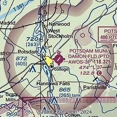
|
| Airport distance calculator |
|---|
|
|
| Sunrise and sunset |
|---|
|
Times for 10-Apr-2025
| | Local
(UTC-4) | | Zulu
(UTC) |
|---|
| Morning civil twilight | | 05:55 | | 09:55 |
| Sunrise | | 06:25 | | 10:25 |
| Sunset | | 19:37 | | 23:37 |
| Evening civil twilight | | 20:07 | | 00:07 |
|
| Current date and time |
|---|
| Zulu (UTC) | 10-Apr-2025 14:30:53 |
|---|
| Local (UTC-4) | 10-Apr-2025 10:30:53 |
|---|
|
| METAR |
|---|
| KPTD | 101415Z AUTO VRB04KT 10SM CLR 03/M08 A3031 RMK AO2 PNO
|
KMSS
16nm N | 101353Z AUTO 14006KT 10SM CLR 03/M07 A3035 RMK AO2 SLP282 T00281072
|
|
| TAF |
|---|
KMSS
16nm N | 101121Z 1012/1112 VRB03KT P6SM FEW200 FM101700 07005KT P6SM OVC120 FM102100 04006KT P6SM OVC070 PROB30 1022/1102 6SM -RA BR OVC035 FM110200 05003KT 4SM -RASN OVC025 FM110600 07005KT P6SM SCT008 OVC015 PROB30 1106/1112 -RASN OVC007
|
|
| NOTAMs |
|---|
NOTAMs are issued by the DoD/FAA and will open in a separate window not controlled by AirNav.
|
|


