FAA INFORMATION EFFECTIVE 16 APRIL 2026
Location
| FAA Identifier: | SJC |
| Lat/Long: | 37-21-46.7810N 121-55-43.0340W
37-21.779683N 121-55.717233W
37.3629947,-121.9286206
(estimated) |
| Elevation: | 62.2 ft. / 19.0 m (surveyed) |
| Variation: | 13E (2020) |
| From city: | 2 miles NW of SAN JOSE, CA |
| Time zone: | UTC -7 (UTC -8 during Standard Time) |
| Zip code: | 95110 |
Airport Operations
| Airport use: | Open to the public |
| Activation date: | 02/1946 |
| Control tower: | yes |
| ARTCC: | OAKLAND CENTER |
| FSS: | OAKLAND FLIGHT SERVICE STATION |
| NOTAMs facility: | SJC (NOTAM-D service available) |
| Attendance: | CONTINUOUS |
| Pattern altitude: | TPA 942 FT AGL SINGLE-ENGINE ACFT, 1442 FT AGL MULTI-ENGINE & TURBINE POWERED ACFT. |
| Wind indicator: | lighted |
| Segmented circle: | yes |
| Lights: | ACTVT MALSR RWY 12R, MALSR RWY 30L, HIRL RWY 12L/30R, HIRL RWY 12R/30L - FREQ 124.0 WHEN TWR CLSD. |
| Beacon: | white-green (lighted land airport)
Operates sunset to sunrise. |
| Fire and rescue: | ARFF index D |
| International operations: | customs landing rights airport |
Airport Communications
| CTAF: | 124.0 |
| UNICOM: | 122.95 |
| WX ASOS: | PHONE 408-969-0838 |
| SAN JOSE GROUND: | 121.7 [0600-0000] |
| SAN JOSE TOWER: | 124.0 257.6 [0600-0000] |
| NORCAL APPROACH: | 120.1 126.475 125.35 134.5 |
| NORCAL DEPARTURE: | 121.3 |
| CLEARANCE DELIVERY: | 118.0 |
| PRE-TAXI CLEARANCE: | 118.0 |
| ALMDN DP: | 121.3 |
| ALTAM DP: | 121.3 |
| BMRNG DP: | 121.3 |
| BRINY STAR: | 133.95 |
| BRIXX STAR: | 133.95 |
| CLASS C: | 120.1 ;081-135 SJC 121.3 ;280-080 SJC 135.2 ;136-279 SJC |
| D-ATIS: | 126.95 |
| DANVILLE DP: | 121.3 |
| FRLON STAR: | 133.95 |
| IC: | 120.1 257.6 |
| LOUPE DP: | 121.3 |
| MOONY DP: | 121.3 |
| POINT REYES STAR: | 133.95 |
| ROBIE STAR: | 124.525 |
| SAN JOSE DP: | 121.3 |
| SHVVR STAR: | 126.475 |
| SILCN STAR: | 124.525 |
| SUNOL DP: | 121.3 |
| TECKY DP: | 121.3 |
| WX AWOS-3PT at NUQ (7 nm NW): | 124.175 (650-386-0655) |
| WX AWOS-3P at SQL (18 nm NW): | 125.9 (650-593-0613) |
| WX ASOS at HWD (20 nm NW): | PHONE 510-786-3052 |
- SAID IN USE. OPERATE TRANSPONDERS WITH ALTITUDE REPORTING MODE AND ADS-B (IF EQUIPPED) ENABLED ON ALL AIRPORT SURFACES.
Nearby radio navigation aids
| VOR radial/distance | | VOR name | | Freq | | Var |
|---|
| SJCr117/1.0 | | SAN JOSE VOR/DME | | 114.10 | | 16E |
| OSIr079/16.9 | | WOODSIDE VOR/DME | | 113.90 | | 17E |
| OAKr130/25.9 | | OAKLAND VOR/DME | | 116.80 | | 17E |
| SFOr109/26.2 | | SAN FRANCISCO VOR/DME | | 115.80 | | 17E |
Airport Services
| Fuel available: | 100LL JET-A |
| Parking: | hangars and tiedowns |
| Airframe service: | MAJOR |
| Powerplant service: | MAJOR |
| Bottled oxygen: | HIGH/LOW |
| Bulk oxygen: | HIGH/LOW |
Runway Information
Runway 12L/30R
| Dimensions: | 11000 x 150 ft. / 3353 x 46 m |
| Surface: | concrete/grooved, in good condition |
| Weight bearing capacity: | | Single wheel: | 120.0 | | Double wheel: | 250.0 | | Double tandem: | 550.0 | | Dual double tandem: | 1116.0 |
|
| Runway edge lights: | high intensity |
| RUNWAY 12L | | RUNWAY 30R |
| Latitude: | 37-22.499668N | | 37-21.135540N |
| Longitude: | 121-56.410628W | | 121-54.915353W |
| Elevation: | 37.7 ft. | | 61.1 ft. |
| Traffic pattern: | left | | right |
| Runway heading: | 126 magnetic, 139 true | | 306 magnetic, 319 true |
| Displaced threshold: | 1308 ft. | | 2537 ft. |
| Declared distances: | TORA:10139 TODA:11000 ASDA:10139 LDA:8831 | | TORA:10134 TODA:11000 ASDA:10134 LDA:7597 |
| Markings: | precision, in good condition | | precision, in good condition |
| Visual slope indicator: | 4-light PAPI on right (3.00 degrees glide path) | | 4-light PAPI on left (3.00 degrees glide path) |
| Runway end identifier lights: | yes | | no |
| Centerline lights: | yes | | yes |
| Touchdown point: | yes, no lights | | yes, no lights |
| Obstructions: | 32 ft. pole, 1441 ft. from runway, 580 ft. right of centerline, 38:1 slope to clear | | 54 ft. tree, 1435 ft. from runway, 550 ft. right of centerline, 23:1 slope to clear |
Runway 12R/30L
| Dimensions: | 11000 x 150 ft. / 3353 x 46 m |
| Surface: | concrete/grooved, in good condition |
| Weight bearing capacity: | | Single wheel: | 120.0 | | Double wheel: | 250.0 | | Double tandem: | 550.0 | | Dual double tandem: | 1120.0 |
|
| Runway edge lights: | high intensity |
| RUNWAY 12R | | RUNWAY 30L |
| Latitude: | 37-22.423777N | | 37-21.059610N |
| Longitude: | 121-56.519328W | | 121-55.024053W |
| Elevation: | 38.2 ft. | | 62.1 ft. |
| Traffic pattern: | right | | left |
| Runway heading: | 126 magnetic, 139 true | | 306 magnetic, 319 true |
| Displaced threshold: | 1297 ft. | | 2537 ft. |
| Declared distances: | TORA:9883 TODA:11000 ASDA:9883 LDA:8587 | | TORA:10152 TODA:11000 ASDA:10152 LDA:7614 |
| Markings: | precision, in good condition | | precision, in good condition |
| Visual slope indicator: | 4-light PAPI on right (3.00 degrees glide path) | | 4-light PAPI on left (3.00 degrees glide path)
RWY 30L PAPI UNUSBL BYD 7 DEGS OF CNTRLN OF RWY. |
| RVR equipment: | touchdown, rollout | | touchdown, rollout |
| Approach lights: | MALSR: 1,400 foot medium intensity approach lighting system with runway alignment indicator lights | | MALSR: 1,400 foot medium intensity approach lighting system with runway alignment indicator lights |
| Runway end identifier lights: | no | | no |
| Centerline lights: | yes | | yes |
| Touchdown point: | yes, no lights | | yes, no lights |
| Instrument approach: | ILS/DME | | ILS/DME |
| Obstructions: | 29 ft. pole, 580 ft. from runway, 480 ft. right of centerline, 13:1 slope to clear
APCH RATIO 50:1 TO DSPLCD THR. | | 14 ft. fence, 230 ft. from runway, 170 ft. right of centerline, 2:1 slope to clear
APCH RATIO 50:1 TO DSPLCD THR. |
Airport Ownership and Management from official FAA records
| Ownership: | Publicly-owned |
| Owner: | CITY OF SAN JOSE
200 E. SANTA CLARA STREET
SAN JOSE, CA 95113
Phone 408-277-5100 |
| Manager: | MUKESH (MOOKIE) PATEL
1701 AIRPORT BLVD., SUITE B-1130
SAN JOSE, CA 95110-1206
Phone (408) 277-5100 |
Additional Remarks
| A39-12L/30R | PCR VALUE: 1008/R/B/W/T |
| A39-12R/30L | PCR VALUE: 1035/R/A/W/T |
| - | TWY Y WILL BE PERIODICALLY RSTRD TO ACFT WITH A WINGSPAN OF LESS THAN 171 FT (MD-11 OR SMALLER) DRG B-787 AND B-747 OPNS ON RWY 12L/30R. |
| - | TWY Z WILL BE PERIODICALLY RSTRD TO ACFT WITH A WINGSPAN OF LESS THAN 118 FT (B-737-900 OR SMALLER) DRG B-787 AND B-747 OPNS. TWY Z BTN 200 FT NW OF TWY H AND 200 FT NW OF TWY K LTD TO ACFT WITH WINGSPAN OF LESS THAN 135 FT (B-757-300 OR SMALLER). |
| - | BIRDS FREQUENTLY ON OR IN VICINITY OF AIRPORT. |
| - | TWY V LTD TO ACFT WITH WINGSPAN OF LESS THAN 118 FT (B-737-900 OR SMALLER). |
| - | UNSCHEDULED OPNS BY GROUP 5 ACFT (B747) AND LARGER NOT AUTH EXCEPT WITH PRIOR ARPT APPROVAL CTC AMGR (408) 392-3500. |
| - | NOISE ABATEMENT PROCEDURE: RY 30L/12R IS PREFERRED ARRIVAL RY FOR JET ACFT AND RY 12L/30R IS THE PREFERRED DEP RY FOR JET ACFT. ALL JET ACFT TKOFS ARE TO BE INITIATED FM EOR UNLESS DIRECTED OTHERWISE BY ATCT. |
| - | CURFEW HRS 2300-0700 FAR 36 STAGE II, 2330-0630 FAR 36 STAGE III ACFT LISTED ON THE SCHEDULE OF AUTHORIZED AIRCRAFT ISSUED BY THE DIRECTOR OF AVIATION. DELAYED SCHEDULED FLIGHTS, AND ALTERNATE/EMERGENCY OPERATIONS MAY BE EXEMPT FROM CURFEW HOUR RESTRICTIONS. |
| - | PRIOR AIRPORT NOTIFICATION IS REQUIRED FOR ALL LATE/EARLY ARRIVALS. CONTACT MANAGER ON DUTY AT (408) 392-3500. |
| - | FIRST 400 FT RY 30R & RY 30L CLSD FOR TKOF DC10, MD11, L1011. |
| - | ALL TURBINE ENGINE RUN-UPS REQUIRE PRIOR AIRPORT APPROVAL, CONTACT MGR ON DUTY (408) 392-3500. |
| - | TWY D BETWEEN TWY W AND TWY V LIMITED TO ACFT WITH A WINGSPAN OF LESS THAN 118 FT (B-737-900 OR SMALLER). |
| - | TWY W BETWEEN TWY J AND TWY L CAN SUPPORT GROUP IV ACFT. |
| - | HIGH INTENSITY LIGHT ACTIVITY: HIGH INTENSITY LIGHTS (LASERS AND LARGE MEDIA SCREENS) MAY BE VISIBLE TO ARR AND DEP ACFT TO SAN JOSE INTERNATIONAL AIRPORT DURING EVENTS AT THE LEVI STADIUM COMPLEX (37-24-15N/121-58-14W, SJC VORTAC R-303/2.1 DME). FLIGHT CREWS SHOULD USE CAUTION WHEN OPERATING IN THIS AREA DURING STADIUM EVENTS. COCKPIT ILLUMINATION AND GLARE EFFECT REDUCING VIS MAY BE INTENSIFIED DURING ARR AND DEP OPS ESPECIALLY AT NIGHT. |
| - | RRP RQRD FM FBO FOR TSNT HEL OPS. |
| - | FOR CD WHEN ATCT IS CLSD CTC NORCAL APCH AT 916-361-3748. |
Instrument Procedures
NOTE: All procedures below are presented as PDF files. If you need a reader for these files, you should download the free Adobe Reader.NOT FOR NAVIGATION. Please procure official charts for flight.
FAA instrument procedures published for use from 16 April 2026 at 0901Z to 14 May 2026 at 0900Z.
STARs - Standard Terminal Arrivals |
|---|
| BRINY TWO | |
download (188KB) |
| BRIXX FOUR (RNAV) | |
download (144KB) |
| FRLON TWO (RNAV) | |
download (147KB) |
| POINT REYES THREE | |
download (222KB) |
| POINT REYES THREE | |
download (222KB) |
| RAZRR FIVE (RNAV) | |
2 pages:
[1] [2] (502KB) |
| RISTI ONE (RNAV) | |
download (135KB) |
| RISTI ONE (RNAV) | |
download (135KB) |
| ROBIE FIVE | |
download (183KB) |
| SILCN SIX (RNAV) | |
2 pages:
[1] [2] (377KB) |
IAPs - Instrument Approach Procedures |
|---|
| ILS OR LOC RWY 12R **CHANGED** | |
download (257KB) |
| ILS OR LOC RWY 30L **CHANGED** | |
download (490KB) |
| ILS RWY 30L (SA CAT I - II) **CHANGED** | |
download (494KB) |
| RNAV (RNP) Z RWY 12L **CHANGED** | |
download (370KB) |
| RNAV (RNP) Z RWY 12R **CHANGED** | |
download (388KB) |
| RNAV (RNP) Z RWY 30L **CHANGED** | |
download (447KB) |
| RNAV (RNP) Z RWY 30R **CHANGED** | |
download (443KB) |
| RNAV (GPS) Y RWY 12L **CHANGED** | |
download (362KB) |
| RNAV (GPS) Y RWY 12R **CHANGED** | |
download (387KB) |
| RNAV (GPS) Y RWY 30L **CHANGED** | |
download (456KB) |
| RNAV (GPS) Y RWY 30R **CHANGED** | |
download (458KB) |
| FAIRGROUNDS VISUAL RWY 30L/R | |
download (236KB) |
| NOTE: Special Alternate Minimums apply **CHANGED** | |
download (137KB) |
Departure Procedures |
|---|
| ALMDN FOUR (RNAV) | |
download (200KB) |
| BMRNG FOUR (RNAV) | |
download (195KB) |
| LOUPE ONE (RNAV) | |
download (254KB) |
| SAN JOSE THREE | |
download (188KB) |
| SPTNS ONE (RNAV) | |
download (212KB) |
| SUNOL ONE | |
download (244KB) |
| TECKY FOUR (RNAV) | |
download (150KB) |
| NOTE: Special Take-Off Minimums/Departure Procedures apply | |
download (187KB) |
Other nearby airports with instrument procedures:
KRHV - Reid-Hillview Airport of Santa Clara County (5 nm E)
KNUQ - Moffett Federal Airfield (7 nm NW)
KPAO - Palo Alto Airport (11 nm NW)
KSQL - San Carlos Airport (18 nm NW)
KHWD - Hayward Executive Airport (20 nm NW)
|
|

Road maps at:
MapQuest
Bing
Google
| Aerial photo |
|---|
WARNING: Photo may not be current or correct
 Photo by @jantheman113
Photo taken 23-Dec-2017
looking northwest.
Photo by @jantheman113
Photo taken 23-Dec-2017
looking northwest.
Do you have a better or more recent aerial photo of Norman Y Mineta San Jose International Airport that you would like to share? If so, please send us your photo.
|
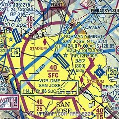
| Sectional chart |
|---|
|
CAUTION: Diagram may not be current
 Download PDF
of official airport diagram from the FAA
| Airport distance calculator |
|---|
|
|
| Sunrise and sunset |
|---|
|
Times for 18-Apr-2026
| | Local
(UTC-7) | | Zulu
(UTC) |
|---|
| Morning civil twilight | | 06:03 | | 13:03 |
| Sunrise | | 06:30 | | 13:30 |
| Sunset | | 19:44 | | 02:44 |
| Evening civil twilight | | 20:11 | | 03:11 |
|
| Current date and time |
|---|
| Zulu (UTC) | 18-Apr-2026 20:43:51 |
|---|
| Local (UTC-7) | 18-Apr-2026 13:43:51 |
|---|
|
| METAR |
|---|
| KSJC | 181953Z 34006KT 10SM BKN100 23/06 A2996 RMK AO2 SLP145 T02330056
|
KNUQ
6nm NW | 182015Z AUTO 35008KT 8SM CLR 22/02 A2996 RMK AO2
|
KRHV
6nm SE | 181947Z 32004KT 10SM SCT100 24/02 A2997
|
KPAO
11nm NW | 181947Z 36008KT 10SM SKC 19/08 A2998
|
KSQL
18nm NW | 181945Z 02007KT 10SM SKC 20/09 A2999
|
|
| TAF |
|---|
| KSJC | 181720Z 1818/1918 VRB03KT P6SM SCT200 FM182000 34014KT P6SM BKN200 FM190500 31007KT P6SM BKN200 FM191100 VRB03KT P6SM BKN200
|
|
| NOTAMs |
|---|
NOTAMs are issued by the DoD/FAA and will open in a separate window not controlled by AirNav.
|
|


