FAA INFORMATION EFFECTIVE 27 NOVEMBER 2025
Location
| FAA Identifier: | HWD |
| Lat/Long: | 37-39-32.1540N 122-07-18.2600W
37-39.535900N 122-07.304333W
37.6589317,-122.1217389
(estimated) |
| Elevation: | 52.1 ft. / 15.9 m (surveyed) |
| Variation: | 15E (2005) |
| From city: | 2 miles W of HAYWARD, CA |
| Time zone: | UTC -8 (UTC -7 during Daylight Saving Time) |
| Zip code: | 94545 |
Airport Operations
| Airport use: | Open to the public |
| Activation date: | 05/1947 |
| Control tower: | yes |
| ARTCC: | OAKLAND CENTER |
| FSS: | OAKLAND FLIGHT SERVICE STATION |
| NOTAMs facility: | HWD (NOTAM-D service available) |
| Attendance: | 0800-1700 |
| Pattern altitude: | TPA: 600'AGL EXCEPT RWY 10L-28R 800'AGL. |
| Wind indicator: | lighted |
| Segmented circle: | yes |
| Lights: | WHEN ATCT CLSD MIRL RWY 10R/28L PRESET LOW INTST; TO INCREASE INTST ACTVT - CTAF. WHEN ATCT CLSD VASI RWY 10R & 28L OPER SS-SR; PAPI RWY 10L & 28R, REIL RWY 10R & 28L UNAVBL. |
| Beacon: | white-green (lighted land airport)
Operates sunset to sunrise. |
Airport Communications
| CTAF: | 120.2 |
| UNICOM: | 122.95 |
| ATIS: | 126.7 |
| WX ASOS: | PHONE 510-786-3052 |
| HAYWARD GROUND: | 121.4 [0700-2100] |
| HAYWARD TOWER: | 120.2 257.8 118.9 [0700-2100] |
| NORCAL APPROACH: | 124.4 125.35 134.5 |
| NORCAL DEPARTURE: | 124.4 |
| CLEARANCE DELIVERY: | 128.05 |
| EMERG: | 121.5 243.0 |
| WX ASOS at OAK (6 nm NW): | PHONE 510-214-1776 |
| WX AWOS-3P at SQL (11 nm SW): | 125.9 (650-593-0613) |
| WX ASOS at SFO (12 nm W): | PHONE 650-250-5841 |
| WX AWOS-AV at 18CN (14 nm NW): | 119.925 (415-514-4209) |
| WX ASOS at LVK (14 nm E): | PHONE 925-606-5412 |
| WX AWOS-3PT at NUQ (15 nm S): | 124.175 (650-386-0655) |
| WX ASOS at SJC (20 nm SE): | 126.95 (408-969-0838) |
- SAID IN USE. OPERATE TRANSPONDERS WITH ALTITUDE REPORTING MODE AND ADS-B (IF EQUIPPED) ENABLED ON ALL AIRPORT SURFACES.
Nearby radio navigation aids
| VOR radial/distance | | VOR name | | Freq | | Var |
|---|
| OAKr113/6.3 | | OAKLAND VOR/DME | | 116.80 | | 17E |
| SFOr062/12.2 | | SAN FRANCISCO VOR/DME | | 115.80 | | 17E |
| OSIr008/17.7 | | WOODSIDE VOR/DME | | 113.90 | | 17E |
| SJCr318/19.0 | | SAN JOSE VOR/DME | | 114.10 | | 16E |
| SAUr105/22.4 | | SAUSALITO VOR/DME | | 116.20 | | 17E |
| CCRr172/23.4 | | CONCORD VOR/DME | | 117.00 | | 17E |
| SGDr142/33.4 | | SCAGGS ISLAND VORTAC | | 112.10 | | 17E |
Airport Services
| Fuel available: | 100LL JET-A UL94
UL94:AVBL AT SELF-SERVE ISLAND. |
| Parking: | tiedowns |
| Airframe service: | MAJOR |
| Powerplant service: | MAJOR |
| Bottled oxygen: | HIGH |
| Bulk oxygen: | HIGH |
Runway Information
Runway 10R/28L
| Dimensions: | 5694 x 150 ft. / 1736 x 46 m |
| Surface: | asphalt/grooved, in excellent condition |
| Weight bearing capacity: | | Single wheel: | 30.0, STRENGTH LIMITED BY STRENGTH OF CONNECTING TAXIWAYS. | | Double wheel: | 75.0 |
|
| Runway edge lights: | medium intensity |
| RUNWAY 10R | | RUNWAY 28L |
| Latitude: | 37-39.722833N | | 37-39.255780N |
| Longitude: | 122-07.787610W | | 122-06.764170W |
| Elevation: | 27.7 ft. | | 52.1 ft. |
| Traffic pattern: | right | | left |
| Runway heading: | 105 magnetic, 120 true | | 285 magnetic, 300 true |
| Displaced threshold: | 826 ft. | | 676 ft. |
| Markings: | precision, in good condition | | precision, in good condition |
| Visual slope indicator: | 4-box VASI on right (3.00 degrees glide path) | | 4-box VASI on left (4.00 degrees glide path) |
| Runway end identifier lights: | yes | | yes |
| Touchdown point: | yes, no lights | | yes, no lights |
| Instrument approach: | | | LOC/DME |
| Obstructions: | 40 ft. tree, 1000 ft. from runway, 250 ft. left of centerline, 20:1 slope to clear
APCH RATIO 45:1 FM DSPLCD THR. | | none |
Runway 10L/28R
| Dimensions: | 3108 x 75 ft. / 947 x 23 m |
| Surface: | asphalt, in good condition |
| Weight bearing capacity: | |
| Runway edge lights: | medium intensity |
| RUNWAY 10L | | RUNWAY 28R |
| Latitude: | 37-39.748707N | | 37-39.493720N |
| Longitude: | 122-07.635822W | | 122-07.077128W |
| Elevation: | 28.1 ft. | | 37.1 ft. |
| Traffic pattern: | left | | right |
| Runway heading: | 105 magnetic, 120 true | | 285 magnetic, 300 true |
| Markings: | nonprecision, in good condition | | nonprecision, in good condition |
| Visual slope indicator: | 4-light PAPI on left (3.00 degrees glide path) | | 4-light PAPI on left (3.00 degrees glide path) |
| Runway end identifier lights: | no | | no |
| Touchdown point: | yes, no lights | | yes, no lights |
| Obstructions: | 60 ft. tree, 1085 ft. from runway, 143 ft. left of centerline, 14:1 slope to clear | | none |
Airport Ownership and Management from official FAA records
| Ownership: | Publicly-owned |
| Owner: | CITY OF HAYWARD
777 B ST
HAYWARD, CA 94541
Phone 510-583-4310
CITY MANAGER |
| Manager: | DOUG MCNEELEY
20301 SKYWEST DR
HAYWARD, CA 94541-4699
Phone (510) 293-8678 |
Additional Remarks
| A91 | INCLUDES 1 AMPHIBIAN. |
| - | 155 FT ENERGY COMPLEX EXHAUST STACK 1 1/2 NM SW OF ARPT. DO NOT OVERFLY ENERGY COMPLEX FACILITY BELOW 1,000 FT MSL. |
| - | TWY Z1 CLSD TO ACFT WITH WINGSPAN GTR THAN 94 FT. |
| - | TWY A NOT VSB FM ATCT BTB TWY B & C |
| - | FOR CD WHEN ATCT IS CLSD CTC NORCAL APCH AT 916-361-0516. |
| - | TWY A1 CLSD TO ACFT WITH WINGSPAN GTR THAN 100 FT. |
| - | WHEN ATCT CLSD RWY 10L/28R CLSD. |
| - | RY 10R HAS LANDING DISTANCE REMAINING SIGNS (LGTD) NORTH SIDE OF RY. |
| - | RY 28L HAS LANDING DISTANCE REMAINING SIGNS (LGTD) SOUTH SIDE OF RY. |
| - | FLOCKS OF BIRDS FEEDING ALONG THE SHORELINE, CREEK AREAS AND AT THE GOLF COURSE TO THE NORTH, ON OCCASION MAY FLY ACROSS VARIOUS PARTS OF THE ARPT. |
| - | NOISE ABATEMENT PROCEDURES IN EFFECT CTC ARPT FOR NOISE RULES 510-293-8669. |
| - | TRANSIENT HELICOPTER TFC USE HELIPADS WEST OF GREEN RAMP LCTD AT BASE OF ATCT. |
Instrument Procedures
NOTE: All procedures below are presented as PDF files. If you need a reader for these files, you should download the free Adobe Reader.NOT FOR NAVIGATION. Please procure official charts for flight.
FAA instrument procedures published for use from 27 November 2025 at 0901Z to 25 December 2025 at 0900Z.
STARs - Standard Terminal Arrivals |
|---|
| EMZOH FOUR (RNAV) | |
2 pages:
[1] [2] (399KB) |
| OAKES THREE (RNAV) | |
2 pages:
[1] [2] (447KB) |
| PANOCHE SIX | |
download (193KB) |
IAPs - Instrument Approach Procedures |
|---|
| RNAV (GPS) RWY 28L | |
download (312KB) |
| LOC RWY 28L | |
download (276KB) |
| NOTE: Special Alternate Minimums apply | |
download (139KB) |
| NOTE: Special Take-Off Minimums/Departure Procedures apply | |
download (364KB) |
Other nearby airports with instrument procedures:
KOAK - Oakland San Francisco Bay Airport (6 nm NW)
KSQL - San Carlos Airport (11 nm SW)
KPAO - Palo Alto Airport (12 nm S)
KSFO - San Francisco International Airport (12 nm W)
KLVK - Livermore Municipal Airport (14 nm E)
KNUQ - Moffett Federal Airfield (15 nm S)
KSJC - Norman Y Mineta San Jose International Airport (20 nm SE)
|
|

Road maps at:
MapQuest
Bing
Google
| Aerial photo |
|---|
WARNING: Photo may not be current or correct
 Photo courtesy of focalflight.com
Photo taken 12-Feb-2017
looking southwest.
Photo courtesy of focalflight.com
Photo taken 12-Feb-2017
looking southwest.
Do you have a better or more recent aerial photo of Hayward Executive Airport that you would like to share? If so, please send us your photo.
|
| Sectional chart |
|---|
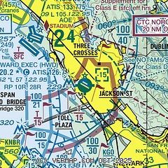
|
CAUTION: Diagram may not be current
 Download PDF
of official airport diagram from the FAA
| Airport distance calculator |
|---|
|
|
| Sunrise and sunset |
|---|
|
Times for 09-Dec-2025
| | Local
(UTC-8) | | Zulu
(UTC) |
|---|
| Morning civil twilight | | 06:44 | | 14:44 |
| Sunrise | | 07:13 | | 15:13 |
| Sunset | | 16:49 | | 00:49 |
| Evening civil twilight | | 17:18 | | 01:18 |
|
| Current date and time |
|---|
| Zulu (UTC) | 09-Dec-2025 23:15:54 |
|---|
| Local (UTC-8) | 09-Dec-2025 15:15:54 |
|---|
|
| METAR |
|---|
| KHWD | 092254Z 25003KT 5SM HZ CLR 12/08 A3019 RMK AO2 SLP232 T01170078
|
KOAK
5nm NW | 092253Z 28012KT 8SM FEW015 FEW200 12/08 A3019 RMK AO2 SLP224 T01170078
|
KSQL
10nm SW | 092247Z 34006KT 10SM SKC 12/08 A3020
|
KPAO
12nm S | 092247Z 34007KT 7SM HZ SKC 12/08 A3020
|
KSFO
12nm W | 092256Z 00000KT 10SM FEW009 12/08 A3019 RMK AO2 SLP224 T01170078 $
|
KLVK
15nm E | 092253Z 05011KT 3SM HZ CLR 08/06 A3020 RMK AO2 SLP226 T00830056
|
KNUQ
15nm S | 092255Z AUTO 35009KT 9SM CLR 12/08 A3019 RMK AO2
|
|
| TAF |
|---|
KOAK
5nm NW | 091722Z 0918/1024 07006KT 6SM BR SCT006 FM092000 28006KT 6SM HZ FEW006 FM100300 VRB03KT 6SM BR FEW007 FM101100 VRB03KT 5SM BR SCT005 FM101700 05006KT 6SM BR FEW005 FM102100 29007KT P6SM FEW200
|
KSFO
12nm W | 092104Z 0921/1024 03006KT P6SM FEW010 FM100300 VRB03KT 6SM HZ FEW007 FM101200 03006KT 5SM BR SCT006 FM101700 03006KT 6SM BR FEW006
|
KLVK
15nm E | 092037Z 0921/1018 08011G15KT 5SM HZ FEW009 FM092300 04010KT 6SM HZ FEW007 FM100200 VRB04KT 3SM BR BKN004 FM100500 05005KT 1SM BR OVC003
|
|
| NOTAMs |
|---|
NOTAMs are issued by the DoD/FAA and will open in a separate window not controlled by AirNav.
|
|


