FAA INFORMATION EFFECTIVE 15 MAY 2025
Location
| FAA Identifier: | SWT |
| Lat/Long: | 40-51-53.0000N 097-06-33.2000W
40-51.883333N 097-06.553333W
40.8647222,-97.1092222
(estimated) |
| Elevation: | 1505.5 ft. / 458.9 m (surveyed) |
| Variation: | 06E (2000) |
| From city: | 3 miles S of SEWARD, NE |
| Time zone: | UTC -5 (UTC -6 during Standard Time) |
| Zip code: | 68434 |
Airport Operations
| Airport use: | Open to the public |
| Activation date: | 01/1976 |
| Control tower: | no |
| ARTCC: | MINNEAPOLIS CENTER |
| FSS: | COLUMBUS FLIGHT SERVICE STATION |
| NOTAMs facility: | OLU (NOTAM-D service available) |
| Attendance: | MON-SAT 0800-1700 |
| Wind indicator: | lighted |
| Segmented circle: | no |
| Lights: | ACTVT MIRL RWY 16/34; PAPI RWY 16 & 34; WINDSOCK - CTAF. |
| Beacon: | white-green (lighted land airport)
Operates sunset to sunrise. |
Airport Communications
| CTAF/UNICOM: | 122.8 |
| OMAHA APPROACH: | 124.0 |
| OMAHA DEPARTURE: | 124.0 |
| WX ASOS at LNK (16 nm E): | PHONE 402-417-0560 |
Nearby radio navigation aids
| VOR radial/distance | | VOR name | | Freq | | Var |
|---|
| LNKr249/17.0 | | LINCOLN VORTAC | | 116.10 | | 09E |
| OLUr155/36.6 | | COLUMBUS VOR/DME | | 116.95 | | 08E |
| BIEr327/(37.5) | | BEATRICE VOR | | 110.60 | | 07E |
| NDB name | | Hdg/Dist | | Freq | | Var | | ID |
|---|
| YORK | | 089/23.1 | | 257 | | 06E | | JYR | .--- -.-- .-. |
| BEKLOF | | 049/26.6 | | 392 | | 03E | | FMZ | ..-. -- --.. |
| WAHOO | | 220/32.2 | | 400 | | 06E | | AHQ | .- .... --.- |
| PLATTE CENTER | | 154/39.9 | | 407 | | 08E | | PLT | .--. .-.. - |
Airport Services
| Fuel available: | 100LL JET-A
100LL:SELF SVC AVBL H24. |
| Parking: | hangars and tiedowns |
| Airframe service: | MAJOR |
| Powerplant service: | MAJOR |
| Bottled oxygen: | NONE |
| Bulk oxygen: | NONE |
Runway Information
Runway 16/34
| Dimensions: | 4200 x 75 ft. / 1280 x 23 m |
| Surface: | concrete, in good condition |
| Weight bearing capacity: | | Single wheel: | 30.0 | | Double wheel: | 45.0 | | Double tandem: | 90.0 |
|
| Runway edge lights: | medium intensity |
| RUNWAY 16 | | RUNWAY 34 |
| Latitude: | 40-52.156262N | | 40-51.467918N |
| Longitude: | 097-06.573540W | | 097-06.485250W |
| Elevation: | 1494.0 ft. | | 1505.4 ft. |
| Traffic pattern: | left | | left |
| Runway heading: | 168 magnetic, 174 true | | 348 magnetic, 354 true |
| Markings: | nonprecision, in good condition | | nonprecision, in good condition |
| Visual slope indicator: | 2-light PAPI on left (3.00 degrees glide path) | | 2-light PAPI on left (3.00 degrees glide path) |
| Touchdown point: | yes, no lights | | yes, no lights |
Runway 4/22
| Dimensions: | 3400 x 150 ft. / 1036 x 46 m |
| Surface: | turf, in good condition |
| RUNWAY 4 | | RUNWAY 22 |
| Latitude: | 40-51.781667N | | 40-52.163250N |
| Longitude: | 097-06.854367W | | 097-06.314583W |
| Elevation: | 1501.0 ft. | | 1490.0 ft. |
| Traffic pattern: | left | | left |
| Runway heading: | 041 magnetic, 047 true | | 221 magnetic, 227 true |
| Touchdown point: | yes, no lights | | yes, no lights |
Airport Ownership and Management from official FAA records
| Ownership: | Publicly-owned |
| Owner: | SEWARD AIRPORT AUTHORITY
1251 280TH RD
SEWARD, NE 68434-0278
Phone 402-643-2125
MARVIN SIEFERT, AIRPORT AUTHORITY CHAIRMAN. |
| Manager: | GREG AND TERRI WHISLER
BOX 278
SEWARD, NE 68434-0278
Phone 402-643-2125 |
Additional Remarks
| A30A-34 | 13 FT ROAD 730 FT FM RWY END XS CNTRLN. |
| A30A-16 | 23 FT ROAD 1225 FT FM RWY END XS CNTRLN. |
| - | FOR CD CTC OMAHA APCH AT 402-682-4395. |
Instrument Procedures
NOTE: All procedures below are presented as PDF files. If you need a reader for these files, you should download the free Adobe Reader.NOT FOR NAVIGATION. Please procure official charts for flight.
FAA instrument procedures published for use from 15 May 2025 at 0901Z to 13 June 2025 at 0900z.
IAPs - Instrument Approach Procedures |
|---|
| RNAV (GPS) RWY 16 | |
download (188KB) |
| RNAV (GPS) RWY 34 | |
download (200KB) |
| NOTE: Special Take-Off Minimums/Departure Procedures apply | |
download (273KB) |
Other nearby airports with instrument procedures:
KLNK - Lincoln Airport (16 nm E)
KCEK - Crete Municipal Airport (17 nm SE)
93Y - David City Municipal Airport (22 nm N)
KJYR - York Municipal Airport (23 nm W)
KFMZ - Fairmont State Airport (27 nm SW)
|
|

Road maps at:
MapQuest
Bing
Google
| Aerial photo |
|---|
WARNING: Photo may not be current or correct
 Photo by Tom Winter
Photo taken 29-Aug-2008
looking south
Photo by Tom Winter
Photo taken 29-Aug-2008
looking south
Do you have a better or more recent aerial photo of Seward Municipal Airport that you would like to share? If so, please send us your photo.
|
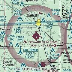
| Sectional chart |
|---|
|
| Airport distance calculator |
|---|
|
|
| Sunrise and sunset |
|---|
|
Times for 16-May-2025
| | Local
(UTC-5) | | Zulu
(UTC) |
|---|
| Morning civil twilight | | 05:40 | | 10:40 |
| Sunrise | | 06:11 | | 11:11 |
| Sunset | | 20:39 | | 01:39 |
| Evening civil twilight | | 21:10 | | 02:10 |
|
| Current date and time |
|---|
| Zulu (UTC) | 16-May-2025 18:53:38 |
|---|
| Local (UTC-5) | 16-May-2025 13:53:38 |
|---|
|
| METAR |
|---|
KLNK
16nm E | 161754Z 29028G40KT 10SM BKN080 22/03 A2958 RMK AO2 PK WND 28040/1753 SLP009 60000 T02220033 10233 20161 53001
|
KJYR
23nm W | 161835Z AUTO 30030G41KT 7SM CLR 21/03 A2962 RMK AO2
|
|
| TAF |
|---|
KLNK
16nm E | 161734Z 1618/1718 28023G38KT P6SM SCT060 FM170300 31017G26KT P6SM SCT100 FM170800 30012KT P6SM SCT035
|
|
| NOTAMs |
|---|
NOTAMs are issued by the DoD/FAA and will open in a separate window not controlled by AirNav.
|
|


