FAA INFORMATION EFFECTIVE 19 FEBRUARY 2026
Location
| FAA Identifier: | U10 |
| Lat/Long: | 42-06-24.9700N 111-54-45.2550W
42-06.416167N 111-54.754250W
42.1069361,-111.9125708
(estimated) |
| Elevation: | 4727.8 ft. / 1441.0 m (surveyed) |
| Variation: | 15E (1985) |
| From city: | 2 miles NW of PRESTON, ID |
| Time zone: | UTC -7 (UTC -6 during Daylight Saving Time) |
| Zip code: | 83263 |
Airport Operations
| Airport use: | Open to the public |
| Activation date: | 04/1940 |
| Control tower: | no |
| ARTCC: | SALT LAKE CITY CENTER |
| FSS: | BOISE FLIGHT SERVICE STATION |
| NOTAMs facility: | BOI (NOTAM-D service available) |
| Attendance: | DAYLIGHT HOURS |
| Wind indicator: | lighted, 3 WINDSOCKS (LGTD) & WIND TEE. |
| Segmented circle: | yes |
| Lights: | ACTVT REIL RWY 04: MIRL RWY 04/22 - CTAF. PAPI RWY 04 & RWY 22 OPR CONSLY. |
| Beacon: | white-green (lighted land airport)
Operates sunset to sunrise. |
Airport Communications
| CTAF/UNICOM: | 122.8 |
| WX ASOS at LGU (19 nm S): | 135.275 (435-752-6941) |
Nearby radio navigation aids
| VOR radial/distance | | VOR name | | Freq | | Var |
|---|
| LHOr359/19.3 | | BRIGHAM CITY VOR/DME | | 112.90 | | 14E |
| MLDr086/24.6 | | MALAD CITY VOR/DME | | 117.40 | | 17E |
Airport Services
| Fuel available: | 100LL |
| Parking: | tiedowns |
| Airframe service: | MINOR |
| Powerplant service: | MINOR |
| Bottled oxygen: | NONE |
| Bulk oxygen: | NONE |
Runway Information
Runway 4/22
| Dimensions: | 3557 x 60 ft. / 1084 x 18 m |
| Surface: | asphalt, in good condition |
| Weight bearing capacity: | |
| Runway edge lights: | medium intensity |
| RUNWAY 4 | | RUNWAY 22 |
| Latitude: | 42-06.248643N | | 42-06.638963N |
| Longitude: | 111-55.021060W | | 111-54.435050W |
| Elevation: | 4725.0 ft. | | 4724.1 ft. |
| Traffic pattern: | left | | left |
| Runway heading: | 033 magnetic, 048 true | | 213 magnetic, 228 true |
| Displaced threshold: | no | | 384 ft.
DSPLCD THR MKD WITH DSPLCD THR BAR ONLY. |
| Markings: | basic, in good condition | | basic, in good condition |
| Visual slope indicator: | 2-light PAPI on left (3.00 degrees glide path) | | 2-light PAPI on left (3.00 degrees glide path)
UNUSBL BYD 4.0 NM FM THR AND DOES NOT PRVD OBSTN CLNC. |
| Runway end identifier lights: | yes | | |
| Touchdown point: | yes, no lights | | yes, no lights |
| Obstructions: | none | | 17 ft. road, 200 ft. from runway, 70 ft. right of centerline
+4' FENCE AT 100', 75' RIGHT. |
Runway 17/35
| Dimensions: | 2375 x 30 ft. / 724 x 9 m |
| Surface: | gravel/dirt, in good condition
GRVL SFC USED BY CROP DUSTERS. |
| RUNWAY 17 | | RUNWAY 35 |
| Latitude: | 42-06.570158N | | 42-06.179337N |
| Longitude: | 111-54.799677W | | 111-54.787200W |
| Elevation: | 4727.7 ft. | | 4727.5 ft. |
| Traffic pattern: | left | | left |
| Runway heading: | 164 magnetic, 179 true | | 344 magnetic, 359 true |
| Markings: | , in fair condition | | , in fair condition |
| Touchdown point: | yes, no lights | | yes, no lights |
Airport Ownership and Management from official FAA records
| Ownership: | Publicly-owned |
| Owner: | CITY OF PRESTON & FRANKLIN CO
70 WEST ONEIDA
PRESTON, ID 83263
Phone 208-852-1817
CITY OF PRESTON'S ADDRESS AND TEL NUMBER. |
| Manager: | CRAIG BIGGS
1319 W 800 NORTH
PRESTON, ID 83263
Phone 208-852-2151 |
Additional Remarks
| - | LCTD ON PLATEAU. SHARP DROPOFF NEAR THR RWYS 04, 17 & 35. |
| - | RWY 17/35 CLSD WINTER. |
| - | FOR CD CTC SALT LAKE ARTCC AT 801-320-2568. |
Instrument Procedures
There are no published instrument procedures at U10.
Some nearby airports with instrument procedures:
KLGU - Logan-Cache Airport (19 nm S)
1U7 - Bear Lake County Airport (27 nm E)
KBMC - Brigham City Regional Airport (34 nm S)
KOGD - Ogden-Hinckley Airport (55 nm S)
KAFO - Afton Lincoln County Airport/General Boyd L Eddins Field (56 nm NE)
|
|

Road maps at:
MapQuest
Bing
Google
| Aerial photo |
|---|
WARNING: Photo may not be current or correct
 Photo by Mike Jesch
Photo taken 03-Jun-2011
looking west at 10,500 feet MSL
Photo by Mike Jesch
Photo taken 03-Jun-2011
looking west at 10,500 feet MSL
Do you have a better or more recent aerial photo of Preston Airport that you would like to share? If so, please send us your photo.
|
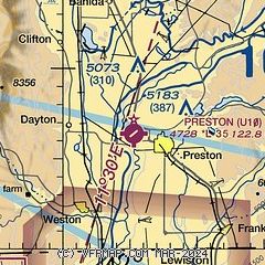
| Sectional chart |
|---|
|
| Airport distance calculator |
|---|
|
|
| Sunrise and sunset |
|---|
|
Times for 12-Mar-2026
| | Local
(UTC-6) | | Zulu
(UTC) |
|---|
| Morning civil twilight | | 07:18 | | 13:18 |
| Sunrise | | 07:46 | | 13:46 |
| Sunset | | 19:29 | | 01:29 |
| Evening civil twilight | | 19:57 | | 01:57 |
|
| Current date and time |
|---|
| Zulu (UTC) | 12-Mar-2026 06:22:44 |
|---|
| Local (UTC-6) | 12-Mar-2026 00:22:44 |
|---|
|
| METAR |
|---|
KLGU
20nm S | 120551Z AUTO 02004KT 10SM CLR 03/M05 A3037 RMK AO2 SLP293 T00281050 10078 20011 58005
|
K1U7
27nm E | 120555Z AUTO 00000KT 10SM CLR 00/M06 A3035 RMK A01
|
KBMC
34nm S | 120555Z AUTO VRB03KT 10SM CLR 07/M04 A3038 RMK AO2 10087 20046 400871040
|
|
| TAF |
|---|
KLGU
20nm S | 120520Z 1206/1306 VRB05KT P6SM BKN100 FM121700 22011G18KT P6SM SCT120 FM122000 27012G20KT P6SM BKN080 FM122300 35009KT P6SM SCT080 BKN100 FM130300 VRB03KT P6SM BKN120
|
|
| NOTAMs |
|---|
NOTAMs are issued by the DoD/FAA and will open in a separate window not controlled by AirNav.
|
|

