FAA INFORMATION EFFECTIVE 15 MAY 2025
Location
| FAA Identifier: | VCV |
| Lat/Long: | 34-35-43.8940N 117-22-57.5840W
34-35.731567N 117-22.959733W
34.5955261,-117.3826622
(estimated) |
| Elevation: | 2885.3 ft. / 879.4 m (surveyed) |
| Variation: | 14E (1995) |
| From city: | 5 miles NW of VICTORVILLE, CA |
| Time zone: | UTC -7 (UTC -8 during Standard Time) |
| Zip code: | 92394 |
Airport Operations
| Airport use: | Open to the public |
| Activation date: | 09/1943 |
| Control tower: | yes |
| ARTCC: | LOS ANGELES CENTER |
| FSS: | RIVERSIDE FLIGHT SERVICE STATION |
| NOTAMs facility: | VCV (NOTAM-D service available) |
| Attendance: | 0600-2000 |
| Wind indicator: | lighted |
| Segmented circle: | yes |
| Lights: | WHEN ATCT CLSD ACTVT PAPI RWY 03, 21, 17 & 35; HIRL RWYS 03/21 & 17/35 - CTAF. |
| Beacon: | white-green (lighted land airport)
Operates sunset to sunrise. |
| Fire and rescue: | ARFF index A |
| Airline operations: | ARFF INDEX A, WITH ARFF INDEX E AVBL WITH 24 HRS PPR; CALL OPNS (760) 243-1915. |
| International operations: | U.S. CUSTOMS USER FEE ARPT. CUSTOMS OFFICER AVBL
1700-0100Z++ MON-FRI 760-243-1925, AFTER HRS CALL
760-490-8651. |
Airport Communications
| CTAF: | 118.35 |
| ATIS: | 135.475 |
| WX AWOS-3: | 135.475 (760-246-3635) |
| VICTORVILLE GROUND: | 124.45 [0600-2000] |
| VICTORVILLE TOWER: | 118.35 282.225 [0600-2000] |
| JOSHUA APPROACH: | 124.55 |
| JOSHUA DEPARTURE: | 124.55 |
| EMERG: | 121.5 |
Nearby radio navigation aids
| VOR radial/distance | | VOR name | | Freq | | Var |
|---|
| VCV at field | | VICTORVILLE VOR/DME | | 109.05 | | 14E |
| EDWr131/28.9 | | EDWARDS VORTAC | | 116.40 | | 12E |
| PMDr079/33.7 | | PALMDALE VORTAC | | 115.55 | | 15E |
| POMr018/36.9 | | POMONA VORTAC | | 110.40 | | 15E |
| RALr351/(38.6) | | RIVERSIDE VOR | | 108.60 | | 14E |
Airport Services
| Fuel available: | 100LL JET-A |
| Oil available: | OPR HRS 2200-0600. |
| Parking: | tiedowns |
| Airframe service: | MAJOR |
| Powerplant service: | MAJOR |
Runway Information
Runway 17/35
| Dimensions: | 13052 x 150 ft. / 3978 x 46 m |
| Surface: | asphalt/concrete/grooved, in good condition |
| Weight bearing capacity: | | PCN 68 /F/A/W/T | | Single wheel: | 60.0 | | Double wheel: | 200.0 | | Double tandem: | 400.0 | | Dual double tandem: | 850.0 |
|
| Runway edge lights: | high intensity |
| RUNWAY 17 | | RUNWAY 35 |
| Latitude: | 34-36.969742N | | 34-34.818473N |
| Longitude: | 117-23.203853W | | 117-23.182058W |
| Elevation: | 2821.5 ft. | | 2885.3 ft. |
| Traffic pattern: | right | | left |
| Runway heading: | 166 magnetic, 180 true | | 346 magnetic, 360 true |
| Declared distances: | TORA:13052 TODA:13052 ASDA:13052 LDA:13052 | | TORA:13052 TODA:13052 ASDA:13052 LDA:13052 |
| Markings: | nonprecision, in good condition | | precision, in good condition |
| Visual slope indicator: | 4-light PAPI on left (3.00 degrees glide path) | | 4-light PAPI on left (3.00 degrees glide path) |
| RVR equipment: | touchdown | | rollout |
| Runway end identifier lights: | yes | | yes |
| Touchdown point: | yes, no lights | | yes, no lights |
| Instrument approach: | LOCALIZER | | |
Runway 3/21
| Dimensions: | 9138 x 150 ft. / 2785 x 46 m |
| Surface: | asphalt/concrete, in good condition |
| Weight bearing capacity: | |
| Runway edge lights: | high intensity |
| RUNWAY 3 | | RUNWAY 21 |
| Latitude: | 34-34.962478N | | 34-36.036292N |
| Longitude: | 117-23.265215W | | 117-21.987963W |
| Elevation: | 2877.8 ft. | | 2844.2 ft. |
| Traffic pattern: | right | | left |
| Runway heading: | 031 magnetic, 045 true | | 211 magnetic, 225 true |
| Declared distances: | TORA:9138 TODA:9138 ASDA:9138 LDA:9138 | | TORA:9138 TODA:9138 ASDA:9138 LDA:9138 |
| Markings: | nonprecision, in good condition | | nonprecision, in good condition |
| Visual slope indicator: | 4-light PAPI on left (3.00 degrees glide path) | | 4-light PAPI on left (3.00 degrees glide path) |
| Runway end identifier lights: | no | | no |
| Touchdown point: | yes, no lights | | yes, no lights |
Airport Ownership and Management from official FAA records
| Ownership: | Publicly-owned |
| Owner: | SOUTHERN CA LOGISTICS ARPT AUTH
18374 PHANTOM
VICTORVILLE, CA 92394
Phone 760-243-1900 |
| Manager: | C. ERIC RAY
SO CAL LOGISTICS AIRPORT AUTHORITY, 18374 PHANTOM WEST
VICTORVILLE, CA 92394
Phone 760-243-1915
AIRPORT OPERATIONS - 760 243-1915 |
Additional Remarks
| - | AVOID OVERFLIGHT OF SILVER LAKES 10 MILES NORTH FOR NOISE ABATEMENT. |
| - | PTN OF TWY A BTN TWY C AND RWY 21, PTN OF TWY C BTN TWY A AND TWY B, PTN OF TWY C BTN TWYS C1 AND C2, PTN OF TWY E BTN TWY E1 AND TWY D, RWY 17 THLD, AND RWY 35 THLD ARE NOT VISIBLE AREAS FROM THE ATCT. VCV ATCT UNA TO PRVD ATC SVCS TO ACFT IN THESE NON-VISIBLE AREAS. |
| - | TWY U NOT AVBL FOR GA OR ACR USE. NOT LGTD. |
| - | PTN OF RWY 17 NORTH 3000 FT ARE NOT VISIBLE AREAS FROM TOWER. |
| - | WHEN ATCT CLSD, FOR CD CTC JOSHUA APCH AT 661-277-3843. |
| - | FOR ACFT FUEL OR MAINT CALL (760) 246-7794 OR USE FREQ 131.975 |
Instrument Procedures
NOTE: All procedures below are presented as PDF files. If you need a reader for these files, you should download the free Adobe Reader.NOT FOR NAVIGATION. Please procure official charts for flight.
FAA instrument procedures published for use from 15 May 2025 at 0901Z to 13 June 2025 at 0900z.
IAPs - Instrument Approach Procedures |
|---|
| RNAV (GPS) RWY 03 | |
download (396KB) |
| RNAV (GPS) RWY 17 | |
download (282KB) |
| RNAV (GPS) RWY 21 | |
download (284KB) |
| RNAV (GPS) RWY 35 | |
download (389KB) |
| LOC RWY 17 | |
download (263KB) |
| VOR/DME RWY 17 | |
download (284KB) |
| NOTE: Special Alternate Minimums apply | |
download (141KB) |
| NOTE: Special Take-Off Minimums/Departure Procedures apply | |
download (132KB) |
Other nearby airports with instrument procedures:
KAPV - Apple Valley Airport (10 nm E)
KSBD - San Bernardino International Airport (31 nm S)
KEDW - Edwards Air Force Base (31 nm NW)
KCCB - Cable Airport (33 nm SW)
KREI - Redlands Municipal Airport (33 nm S)
|
|

Road maps at:
MapQuest
Bing
Google
| Aerial photo |
|---|
WARNING: Photo may not be current or correct
 Photo by www.focalflight.com
Photo taken 27-Apr-2020
looking north.
Photo by www.focalflight.com
Photo taken 27-Apr-2020
looking north.
Do you have a better or more recent aerial photo of Southern California Logistics Airport that you would like to share? If so, please send us your photo.
|
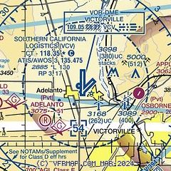
| Sectional chart |
|---|
|
CAUTION: Diagram may not be current
 Download PDF
of official airport diagram from the FAA
| Airport distance calculator |
|---|
|
|
| Sunrise and sunset |
|---|
|
Times for 07-Jun-2025
| | Local
(UTC-7) | | Zulu
(UTC) |
|---|
| Morning civil twilight | | 05:08 | | 12:08 |
| Sunrise | | 05:37 | | 12:37 |
| Sunset | | 19:59 | | 02:59 |
| Evening civil twilight | | 20:29 | | 03:29 |
|
| Current date and time |
|---|
| Zulu (UTC) | 08-Jun-2025 03:41:03 |
|---|
| Local (UTC-7) | 07-Jun-2025 20:41:03 |
|---|
|
| METAR |
|---|
| KVCV | 080315Z AUTO 15004KT 10SM CLR 27/07 A2998 RMK AO2
|
|
| TAF |
|---|
KSBD
31nm S | 071734Z 0718/0818 VRB04KT P6SM FEW012 FM072200 25011KT P6SM SKC FM080500 VRB04KT P6SM SKC FM081100 VRB04KT 4SM BR OVC008 FM081700 VRB04KT 6SM HZ BKN010
|
KDAG
33nm NE | 071720Z 0718/0818 32007KT P6SM SKC FM071900 09010KT P6SM SKC FM080400 23011KT P6SM SKC FM080700 28011KT P6SM SKC
|
KONT
34nm S | 071734Z 0718/0824 VRB04KT P6SM SCT015 FM072100 25011KT P6SM SKC FM080900 VRB04KT 4SM BR OVC008 FM081700 VRB04KT P6SM SCT012 FM082100 25011KT P6SM SKC
|
KPMD
35nm W | 072101Z 0721/0818 23015G22KT P6SM SKC FM080300 21010KT P6SM SKC FM081400 VRB05KT P6SM SKC
|
|
| NOTAMs |
|---|
NOTAMs are issued by the DoD/FAA and will open in a separate window not controlled by AirNav.
|
|


