FAA INFORMATION EFFECTIVE 25 DECEMBER 2025
Location
| FAA Identifier: | X14 |
| Lat/Long: | 26-44-26.1000N 081-25-41.8000W
26-44.435000N 081-25.696667W
26.7405833,-81.4282778
(estimated) |
| Elevation: | 20.2 ft. / 6 m (estimated) |
| Variation: | 05W (2010) |
| From city: | 1 mile S of LA BELLE, FL |
| Time zone: | UTC -5 (UTC -4 during Daylight Saving Time) |
| Zip code: | 33935 |
Airport Operations
| Airport use: | Open to the public |
| Activation date: | 01/1956 |
| Control tower: | no |
| ARTCC: | MIAMI CENTER |
| FSS: | MIAMI FLIGHT SERVICE STATION |
| NOTAMs facility: | MIA (NOTAM-D service available) |
| Attendance: | MON-FRI 0800-1700 |
| Wind indicator: | lighted |
| Segmented circle: | no |
| Lights: | ACTVT REIL RWY 14 & 32; PAPI RWY 14 & 32; MIRL RWY 14/32 - CTAF. |
| Beacon: | white-green (lighted land airport)
Operates sunset to sunrise. |
Airport Communications
| CTAF/UNICOM: | 122.8 |
| FORT MYERS APPROACH: | 126.8 [1200-0300Z++] |
| FORT MYERS DEPARTURE: | 126.8 [1200-0300Z++] |
| WX AWOS-3 at IMM (18 nm S): | 118.525 (239-657-2038) |
- APCH/DEP SVC PRVDD BY MIAMI ARTCC ON FREQS 134.75 (FORT MYERS RCAG) WHEN FORT MYERS APCH CTL CLSD.
Nearby radio navigation aids
| VOR radial/distance | | VOR name | | Freq | | Var |
|---|
| RSWr058/22.5 | | LEE COUNTY VORTAC | | 114.15 | | 02W |
Airport Services
| Fuel available: | 100LL JET-A
100LL:FUEL AVBL H24 WIH CREDIT CARD. |
| Parking: | tiedowns |
| Airframe service: | MINOR |
| Powerplant service: | MAJOR |
| Bottled oxygen: | NONE |
| Bulk oxygen: | NONE |
Runway Information
Runway 14/32
| Dimensions: | 5254 x 75 ft. / 1601 x 23 m |
| Surface: | asphalt, in good condition |
| Weight bearing capacity: | | PCN 20 /F/A/Y/T | | Single wheel: | 62.0 | | Double wheel: | 87.0 |
|
| Runway edge lights: | medium intensity |
| RUNWAY 14 | | RUNWAY 32 |
| Latitude: | 26-44.750245N | | 26-44.118422N |
| Longitude: | 081-26.028010W | | 081-25.366297W |
| Elevation: | 18.1 ft. | | 20.1 ft. |
| Traffic pattern: | left | | left |
| Runway heading: | 142 magnetic, 137 true | | 322 magnetic, 317 true |
| Displaced threshold: | 351 ft. | | 129 ft. |
| Declared distances: | TORA:5254 TODA:5254 ASDA:5254 LDA:4903 | | TORA:5254 TODA:5254 ASDA:5254 LDA:5125 |
| Markings: | nonprecision, in fair condition | | nonprecision, in fair condition |
| Visual slope indicator: | 4-light PAPI on left (3.00 degrees glide path) | | 4-light PAPI on left (3.00 degrees glide path) |
| Runway end identifier lights: | yes | | yes |
| Touchdown point: | yes, no lights | | yes, no lights |
| Obstructions: | 15 ft. road, 257 ft. from runway, 250 ft. left of centerline, 3:1 slope to clear
RWY 14 APCH RATIO 24:1 TO DTHR DUE TO 36 FT TREES 170 FT L OF CNTRLN 505 FT FM DTHR. | | 15 ft. road, 365 ft. from runway, 250 ft. right of centerline, 11:1 slope to clear
RWY 32 APCH RATIO 34:1 TO DTHR. |
Airport Ownership and Management from official FAA records
| Ownership: | Publicly-owned |
| Owner: | HENDRY COUNTY
99 EAST COWBOY WAY
LABELLE, FL 33975-1607
Phone 863-675-5329
CTC PERSON: TOMMY VAUGHAN 863-675-5252. |
| Manager: | NAOMI GILDE
311 E COWBOY WAY
LABELLE, FL 33935-1607
Phone 863-675-1568 |
Additional Remarks
| - | TKOFS AND LNDGS ON TURF AREAS NA. |
| - | GLDR ACTVTY WITHIN 5 NM SFC-6000 FT. |
| - | FOR CD CTC FORT MYERS APCH AT 239-416-1026, WHEN APCH CLSD CTC MIAMI ARTCC AT 305-716-1731. |
| - | 7 FT FENCE 300 FT FM AER RWY 14 165 FT LEFT. |
Instrument Procedures
NOTE: All procedures below are presented as PDF files. If you need a reader for these files, you should download the free Adobe Reader.NOT FOR NAVIGATION. Please procure official charts for flight.
FAA instrument procedures published for use from 25 December 2025 at 0901z to 22 January 2026 at 0900z.
IAPs - Instrument Approach Procedures |
|---|
| RNAV (GPS) RWY 14 | |
download (184KB) |
| RNAV (GPS) RWY 32 | |
download (220KB) |
| NOTE: Special Take-Off Minimums/Departure Procedures apply | |
download (162KB) |
Other nearby airports with instrument procedures:
KIMM - Immokalee Regional Airport (18 nm S)
2IS - Airglades Airport (20 nm E)
KRSW - Southwest Florida International Airport (21 nm SW)
KFMY - Page Field Airport (25 nm W)
KPGD - Punta Gorda Airport (32 nm W)
|
|

Road maps at:
MapQuest
Bing
Google
| Aerial photo |
|---|
WARNING: Photo may not be current or correct
 Photo by Dave Fogarty DPE/ATP/CFI/A&P-IA/FAAST
Photo taken 10-Mar-2019
looking east-northeast at 7,000 MSL
Photo by Dave Fogarty DPE/ATP/CFI/A&P-IA/FAAST
Photo taken 10-Mar-2019
looking east-northeast at 7,000 MSL
Do you have a better or more recent aerial photo of La Belle Municipal Airport that you would like to share? If so, please send us your photo.
|
| Sectional chart |
|---|
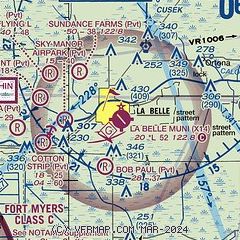
|
| Airport distance calculator |
|---|
|
|
| Sunrise and sunset |
|---|
|
Times for 28-Dec-2025
| | Local
(UTC-5) | | Zulu
(UTC) |
|---|
| Morning civil twilight | | 06:49 | | 11:49 |
| Sunrise | | 07:14 | | 12:14 |
| Sunset | | 17:40 | | 22:40 |
| Evening civil twilight | | 18:06 | | 23:06 |
|
| Current date and time |
|---|
| Zulu (UTC) | 29-Dec-2025 03:43:04 |
|---|
| Local (UTC-5) | 28-Dec-2025 22:43:04 |
|---|
|
| METAR |
|---|
KIMM
18nm S | 290145Z AUTO 30003KT 10SM CLR 16/16 A3009 RMK AO2
|
|
| TAF |
|---|
KRSW
22nm SW | 282254Z 2823/2918 VRB04KT P6SM FEW250 FM290700 VRB03KT 5SM BR FEW250 FM291000 VRB03KT 1/2SM FG FEW250 FM291400 26006KT P6SM SKC
|
KFMY
25nm W | 281737Z 2818/2918 VRB04KT P6SM SKC FM282100 26006KT P6SM SKC FM290000 VRB03KT P6SM SKC FM291600 27006KT P6SM SKC
|
|
| NOTAMs |
|---|
NOTAMs are issued by the DoD/FAA and will open in a separate window not controlled by AirNav.
|
|


