FAA INFORMATION EFFECTIVE 19 FEBRUARY 2026
Location
| FAA Identifier: | Y91 |
| Lat/Long: | 44-19-12.4955N 085-10-12.7107W
44-19.208258N 085-10.211845W
44.3201376,-85.1701974
(estimated) |
| Elevation: | 1246 ft. / 380 m (estimated) |
| Variation: | 05W (1985) |
| From city: | 2 miles E of LAKE CITY, MI |
| Time zone: | UTC -5 (UTC -4 during Daylight Saving Time) |
| Zip code: | 49651 |
Airport Operations
| Airport use: | Open to the public |
| Activation date: | 06/1947 |
| Control tower: | no |
| ARTCC: | MINNEAPOLIS CENTER |
| FSS: | LANSING FLIGHT SERVICE STATION |
| NOTAMs facility: | LAN (NOTAM-D service available) |
| Attendance: | IREG |
| Pattern altitude: | 2046 ft. MSL |
| Wind indicator: | yes |
| Segmented circle: | yes |
| Lights: | ACTVT LIRL RWY 09/27 & 18/36 - CTAF. |
| Beacon: | white-green (lighted land airport)
Operates sunset to sunrise. |
Airport Communications
| CTAF/UNICOM: | 123.0 |
| WX AWOS-3P at CAD (11 nm W): | 128.325 (231-779-9536) |
Nearby radio navigation aids
| VOR radial/distance | | VOR name | | Freq | | Var |
|---|
| TVCr144/26.5 | | TRAVERSE CITY VOR/DME | | 114.60 | | 02W |
| CGGr227/(28.8) | | GRAYLING VOR | | 109.80 | | 06W |
| NDB name | | Hdg/Dist | | Freq | | Var | | ID |
|---|
| GRAYLING | | 216/29.6 | | 359 | | 06W | | GYG | --. -.-- --. |
Airport Services
| Parking: | hangars and tiedowns |
| Airframe service: | NONE |
| Powerplant service: | NONE |
Runway Information
Runway 9/27
| Dimensions: | 3830 x 160 ft. / 1167 x 49 m |
| Surface: | turf, in good condition |
| Runway edge lights: | low intensity |
| Runway edge markings: | RWY & DTHR MKD WITH 3 FT YELLOW CONES. |
| RUNWAY 9 | | RUNWAY 27 |
| Latitude: | 44-19.202667N | | 44-19.191667N |
| Longitude: | 085-10.517833W | | 085-09.640000W |
| Elevation: | 1237.0 ft. | | 1237.0 ft. |
| Traffic pattern: | left | | left |
| Runway heading: | 096 magnetic, 091 true | | 276 magnetic, 271 true |
| Displaced threshold: | 376 ft. | | 1164 ft. |
| Runway end identifier lights: | no | | no |
| Obstructions: | 15 ft. road, 46 ft. from runway, 130 ft. left and right of centerline, 3:1 slope to clear
APCH RATIO 14:1 TO DTHR OVR 68 FT TREES, 952 FT DIST, 150 FT L. | | 65 ft. trees, 55 ft. from runway, 80 ft. right of centerline
APCH RATIO 7:1 TO DTHR OVR 85 FT TREE, 670 FT DIST, 192 FT L. |
Runway 18/36
| Dimensions: | 2550 x 150 ft. / 777 x 46 m |
| Surface: | turf, in good condition |
| Runway edge lights: | low intensity |
| Runway edge markings: | RWY & DTHR MKD WITH 3 FT YELLOW CONES. |
| RUNWAY 18 | | RUNWAY 36 |
| Latitude: | 44-19.434833N | | 44-19.015000N |
| Longitude: | 085-10.411500W | | 085-10.411500W |
| Elevation: | 1238.0 ft. | | 1238.0 ft. |
| Traffic pattern: | left | | left |
| Runway heading: | 185 magnetic, 180 true | | 005 magnetic, 360 true |
| Displaced threshold: | 257 ft. | | 396 ft. |
| Runway end identifier lights: | no | | no |
| Obstructions: | 15 ft. road, 43 ft. from runway, 129 ft. left and right of centerline, 2:1 slope to clear
APCH RATIO 0:1 TO DTHR OVR 65 FT TREES, 0 FT DIST, 120 FT L. | | 68 ft. trees, 556 ft. from runway, 150 ft. left of centerline, 8:1 slope to clear
APCH RATIO 3:1 TO DTHR OVR 41 FT TREES, 130 FT DIST, 135 FT R. |
Airport Ownership and Management from official FAA records
| Ownership: | Privately-owned |
| Owner: | FRIENDS OF LAKE CITY AIRPORT
1358 S TAXIWAY ALPHA
LAKE CITY, MI 49651-7707
Phone 231-920-2407 |
| Manager: | BRIAN WEAVER
1358 S TAXIWAY ALPHA
LAKE CITY, MI 49651-9205
Phone 480-382-7330
ASST AMGR MITCH TUCKER 231-878-2695. |
Additional Remarks
| - | NO SNOW REMOVAL - CALL AMGR FOR FLD CONDS. |
| - | DEER & BIRDS ON & INVOF ARPT. |
| - | TALL TREES ALG & AT THE INT OF RWY 09/27 & 18/36 OBSTG VIEW OF ADJ RWY. |
| - | UAS OPR NW CORNER OF ARPT. |
| - | FOR CD CTC MINNEAPOLIS ARTCC AT 651-463-5588. |
Instrument Procedures
There are no published instrument procedures at Y91.
Some nearby airports with instrument procedures:
KCAD - Wexford County Airport (11 nm W)
KHTL - Roscommon County/Blodgett Memorial Airport (22 nm E)
KGOV - Grayling Army Airfield (29 nm NE)
KTVC - Cherry Capital Airport (31 nm NW)
48D - Clare Municipal Airport (35 nm SE)
|
|

Road maps at:
MapQuest
Bing
Google
| Aerial photo |
|---|
WARNING: Photo may not be current or correct
 Photo by Dennis Daniels
Taken in the Summer of 2005
taken just sw of the airport looking down rw9
Photo by Dennis Daniels
Taken in the Summer of 2005
taken just sw of the airport looking down rw9
Do you have a better or more recent aerial photo of Home Acres Sky Ranch Airport that you would like to share? If so, please send us your photo.
|
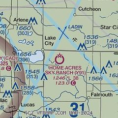
| Sectional chart |
|---|
|
| Airport distance calculator |
|---|
|
|
| Sunrise and sunset |
|---|
|
Times for 24-Feb-2026
| | Local
(UTC-5) | | Zulu
(UTC) |
|---|
| Morning civil twilight | | 06:58 | | 11:58 |
| Sunrise | | 07:27 | | 12:27 |
| Sunset | | 18:21 | | 23:21 |
| Evening civil twilight | | 18:50 | | 23:50 |
|
| Current date and time |
|---|
| Zulu (UTC) | 24-Feb-2026 12:24:51 |
|---|
| Local (UTC-5) | 24-Feb-2026 07:24:51 |
|---|
|
| METAR |
|---|
KCAD
11nm W | 241155Z AUTO 16004KT 10SM SCT020 SCT070 BKN110 M11/M14 A2997 RMK AO2 11105 21123 70000
|
KHTL
22nm E | 241153Z AUTO 11004KT 10SM CLR M14/M16 A3000 RMK AO2 SLP186 I6000 T11441161 11128 21161 56027 $
|
|
| TAF |
|---|
KTVC
30nm NW | 240520Z 2406/2506 VRB04KT P6SM BKN027 FM241000 15007KT P6SM SCT028 OVC100 FM241500 17014G26KT P6SM OVC045 FM242100 19014G28KT 1SM -SN OVC018 FM242300 21010G18KT 2SM -SHSN BKN028 FM250200 25010G17KT 4SM -SHSN BKN028
|
|
| NOTAMs |
|---|
NOTAMs are issued by the DoD/FAA and will open in a separate window not controlled by AirNav.
|
|

