FAA INFORMATION EFFECTIVE 22 JANUARY 2026
Location
| FAA Identifier: | 48D |
| Lat/Long: | 43-50-04.0000N 084-44-24.8000W
43-50.066667N 084-44.413333W
43.8344444,-84.7402222
(estimated) |
| Elevation: | 856 ft. / 260.9 m (surveyed) |
| Variation: | 05W (1995) |
| From city: | 1 mile NE of CLARE, MI |
| Time zone: | UTC -5 (UTC -4 during Daylight Saving Time) |
| Zip code: | 48617 |
Airport Operations
| Airport use: | Open to the public |
| Activation date: | 03/1941 |
| Control tower: | no |
| ARTCC: | CLEVELAND CENTER |
| FSS: | LANSING FLIGHT SERVICE STATION |
| NOTAMs facility: | LAN (NOTAM-D service available) |
| Attendance: | IREG |
| Wind indicator: | lighted |
| Segmented circle: | yes |
| Lights: | ACTVT REIL RWY 04 & 22; PAPI RWY 04 & 22; MIRL RWY 04/22 & 09/27 - CTAF. |
| Beacon: | white-green (lighted land airport)
Operates sunset to sunrise. |
Airport Communications
| CTAF/UNICOM: | 122.8 |
| GREAT LAKES APPROACH: | 126.45 |
| GREAT LAKES DEPARTURE: | 126.45 |
| WX AWOS-3 at MOP (13 nm S): | 133.025 (989-773-2885) |
- APCH/DEP SVC PRVDD BY CLEVELAND ARTCC (ZOB) ON FREQS 127.7/290.425 (FREELAND RCAG) WHEN GREAT LAKES APCH CTL CLSD.
Nearby radio navigation aids
| VOR radial/distance | | VOR name | | Freq | | Var |
|---|
| MOPr004/12.7 | | MOUNT PLEASANT VOR/DME | | 110.60 | | 05W |
| MBSr305/34.0 | | SAGINAW VOR/DME | | 114.35 | | 03W |
Airport Services
| Fuel available: | 100LL
100LL:FUEL AVBL H24 SELF SVC VIA CREDIT CARD. |
| Parking: | hangars and tiedowns |
| Airframe service: | MAJOR |
| Powerplant service: | MAJOR |
| Bottled oxygen: | NONE |
| Bulk oxygen: | NONE |
Runway Information
Runway 4/22
| Dimensions: | 3500 x 75 ft. / 1067 x 23 m |
| Surface: | asphalt, in good condition |
| Runway edge lights: | medium intensity |
| Runway edge markings: | FADED. |
| RUNWAY 4 | | RUNWAY 22 |
| Latitude: | 43-49.966103N | | 43-50.462723N |
| Longitude: | 084-44.562813W | | 084-44.159690W |
| Elevation: | 826.2 ft. | | 855.9 ft. |
| Traffic pattern: | left | | left |
| Runway heading: | 035 magnetic, 030 true | | 215 magnetic, 210 true |
| Markings: | nonprecision, in fair condition | | nonprecision, in fair condition |
| Visual slope indicator: | 4-light PAPI on left (4.00 degrees glide path) | | 2-light PAPI on left (3.00 degrees glide path) |
| Runway end identifier lights: | yes | | yes |
| Touchdown point: | yes, no lights | | yes, no lights |
Runway 9/27
| Dimensions: | 2499 x 75 ft. / 762 x 23 m |
| Surface: | asphalt, in good condition |
| Weight bearing capacity: | |
| Runway edge lights: | medium intensity |
| Runway edge markings: | FADED. |
| RUNWAY 9 | | RUNWAY 27 |
| Latitude: | 43-49.839527N | | 43-49.882642N |
| Longitude: | 084-44.766942W | | 084-44.201818W |
| Elevation: | 829.7 ft. | | 821.8 ft. |
| Traffic pattern: | left | | left |
| Runway heading: | 089 magnetic, 084 true | | 269 magnetic, 264 true |
| Markings: | nonprecision, in fair condition | | nonprecision, in fair condition |
| Runway end identifier lights: | no | | no |
| Touchdown point: | yes, no lights | | yes, no lights |
Airport Ownership and Management from official FAA records
| Ownership: | Publicly-owned |
| Owner: | CITY OF CLARE
202 W 5TH ST
CLARE, MI 48617-1490
Phone 989-386-7541 |
| Manager: | GARY TODD
202 W 5TH ST
CLARE, MI 48617-1490
Phone 989-386-0445
CELL 989-802-2005. |
Additional Remarks
| - | DEER & LRG BIRDS ON & INVOF ARPT. |
| - | ADMIN BLDG ACES: PRESS V, THEN III & II SIMUL, THEN I. |
| - | FOR CD CTC GREAT LAKES APCH AT 269-459-3345, WHEN APCH CLSD CTC CLEVELAND ARTCC AT 440-774-0224/0490. |
Instrument Procedures
NOTE: All procedures below are presented as PDF files. If you need a reader for these files, you should download the free Adobe Reader.NOT FOR NAVIGATION. Please procure official charts for flight.
FAA instrument procedures published for use from 22 January 2026 at 0901Z to 19 February 2026 at 0900z.
IAPs - Instrument Approach Procedures |
|---|
| RNAV (GPS) RWY 04 | |
download (207KB) |
| NOTE: Special Take-Off Minimums/Departure Procedures apply | |
download (124KB) |
Other nearby airports with instrument procedures:
KMOP - Mount Pleasant Municipal Airport (13 nm S)
KGDW - Gladwin Zettel Memorial Airport (14 nm NE)
KIKW - Jack Barstow Airport (23 nm SE)
KAMN - Gratiot Community Airport (31 nm S)
KHTL - Roscommon County/Blodgett Memorial Airport (32 nm N)
|
|

Road maps at:
MapQuest
Bing
Google
| Aerial photo |
|---|
WARNING: Photo may not be current or correct

Do you have a better or more recent aerial photo of Clare Municipal Airport that you would like to share? If so, please send us your photo.
|
| Sectional chart |
|---|
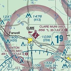
|
| Airport distance calculator |
|---|
|
|
| Sunrise and sunset |
|---|
|
Times for 02-Feb-2026
| | Local
(UTC-5) | | Zulu
(UTC) |
|---|
| Morning civil twilight | | 07:25 | | 12:25 |
| Sunrise | | 07:56 | | 12:56 |
| Sunset | | 17:50 | | 22:50 |
| Evening civil twilight | | 18:20 | | 23:20 |
|
| Current date and time |
|---|
| Zulu (UTC) | 02-Feb-2026 06:55:42 |
|---|
| Local (UTC-5) | 02-Feb-2026 01:55:42 |
|---|
|
| METAR |
|---|
KMOP
13nm S | 020635Z AUTO 15003KT 10SM CLR M12/M15 A3008 RMK AO2 T11231148
|
KIKW
23nm SE | 020635Z AUTO 00000KT 10SM CLR M16/M18 A3010 RMK AO2
|
|
| TAF |
|---|
KMBS
34nm SE | 020520Z 0206/0306 21005KT P6SM SCT250 FM021200 20005KT 5SM -SN SCT014 OVC040 FM021400 20006KT 3SM -SN BR SCT008 OVC014 FM021800 22009KT 6SM -SHSN BKN020 OVC040 FM030100 24005KT P6SM OVC040
|
|
| NOTAMs |
|---|
NOTAMs are issued by the DoD/FAA and will open in a separate window not controlled by AirNav.
|
|

