FAA INFORMATION EFFECTIVE 15 MAY 2025
Location
| FAA Identifier: | EWK |
| Lat/Long: | 38-03-25.5650N 097-16-30.8220W
38-03.426083N 097-16.513700W
38.0571014,-97.2752283
(estimated) |
| Elevation: | 1533.5 ft. / 467 m (estimated) |
| Variation: | 06E (2000) |
| From city: | 3 miles E of NEWTON, KS |
| Time zone: | UTC -5 (UTC -6 during Standard Time) |
| Zip code: | 67114 |
Airport Operations
| Airport use: | Open to the public |
| Activation date: | 02/1944 |
| Control tower: | no |
| ARTCC: | KANSAS CITY CENTER |
| FSS: | WICHITA FLIGHT SERVICE STATION |
| NOTAMs facility: | EWK (NOTAM-D service available) |
| Attendance: | 0700-2300
PHONE NUMBER FOR FUEL AFT HRS 316-284-6084 AND IS POSTED AT ARPT. |
| Wind indicator: | lighted |
| Segmented circle: | no |
| Lights: | ACTVT MALSR RWY 17; REIL RWYS 08 & 26 &35; VASI RWY 35; PAPI RWYS 08 & 26 & 17; HIRL RWY 17/35 - CTAF. |
| Beacon: | white-green (lighted land airport)
Operates sunset to sunrise. |
Airport Communications
| CTAF/UNICOM: | 123.0 |
| WX AWOS-3PT: | 123.875 (316-283-8789) |
| WICHITA APPROACH: | 125.5 |
| WICHITA DEPARTURE: | 125.5 |
| CLEARANCE DELIVERY: | 126.55 |
| WX AWOS-2 at 1K1 (19 nm SE): | 118.3 (316-530-6004) |
| WX ASOS at AAO (19 nm S): | 134.025 (316-636-2541) |
Nearby radio navigation aids
| VOR radial/distance | | VOR name | | Freq | | Var |
|---|
| ICTr031/23.7 | | WICHITA VORTAC | | 113.80 | | 07E |
| HUTr079/31.4 | | HUTCHINSON VOR/DME | | 116.80 | | 04E |
| NDB name | | Hdg/Dist | | Freq | | Var | | ID |
|---|
| HARVS | | 174/5.3 | | 395 | | 06E | | CA | -.-. .- |
Airport Services
| Fuel available: | 100LL JET-A |
| Parking: | hangars and tiedowns |
| Airframe service: | MAJOR |
| Powerplant service: | MAJOR |
| Bottled oxygen: | NONE |
| Bulk oxygen: | LOW |
Runway Information
Runway 17/35
| Dimensions: | 7003 x 100 ft. / 2135 x 30 m |
| Surface: | concrete, in good condition |
| Weight bearing capacity: | | PCN 21 /R/C/X/U | | Single wheel: | 50.0 | | Double wheel: | 75.0 | | Double tandem: | 135.0 |
|
| Runway edge lights: | high intensity |
| RUNWAY 17 | | RUNWAY 35 |
| Latitude: | 38-03.893167N | | 38-02.739333N |
| Longitude: | 097-16.583167W | | 097-16.583167W |
| Elevation: | 1528.8 ft. | | 1524.5 ft. |
| Traffic pattern: | left | | left |
| Runway heading: | 174 magnetic, 180 true | | 354 magnetic, 000 true |
| Declared distances: | TORA:7003 TODA:7003 ASDA:6705 LDA:6705 | | TORA:7003 TODA:7003 ASDA:7003 LDA:7003 |
| Markings: | precision, in good condition | | nonprecision, in good condition |
| Visual slope indicator: | 2-light PAPI on left (3.00 degrees glide path) | | 4-box VASI on left (3.00 degrees glide path) |
| Approach lights: | MALSR: 1,400 foot medium intensity approach lighting system with runway alignment indicator lights | | |
| Runway end identifier lights: | | | yes |
| Touchdown point: | yes, no lights | | yes, no lights |
| Instrument approach: | ILS | | |
Runway 8/26
| Dimensions: | 3501 x 60 ft. / 1067 x 18 m
RWY 08/26 60 FT WIDE ASPHALT. |
| Surface: | asphalt, in good condition |
| Weight bearing capacity: | | PCN 6 /F/D/Y/U | | Single wheel: | 13.0 |
|
| Runway edge lights: | medium intensity |
| RUNWAY 8 | | RUNWAY 26 |
| Latitude: | 38-03.645833N | | 38-03.645833N |
| Longitude: | 097-16.739333W | | 097-16.010000W |
| Elevation: | 1533.5 ft. | | 1533.3 ft. |
| Traffic pattern: | left | | left |
| Runway heading: | 084 magnetic, 090 true | | 264 magnetic, 270 true |
| Declared distances: | TORA:3501 TODA:3501 ASDA:3501 LDA:3501 | | TORA:3501 TODA:3501 ASDA:3501 LDA:3501 |
| Markings: | basic, in good condition | | basic, in good condition |
| Visual slope indicator: | 4-light PAPI on left (3.00 degrees glide path)
RWY 08 PAPI OTS. | | 4-light PAPI on left (3.00 degrees glide path) |
| Runway end identifier lights: | yes | | yes |
| Touchdown point: | yes, no lights | | yes, no lights |
| Obstructions: | none | | 34 ft. pole, 841 ft. from runway, 272 ft. left and right of centerline, 18:1 slope to clear |
Airport Ownership and Management from official FAA records
| Ownership: | Publicly-owned |
| Owner: | CITY OF NEWTON HARVEY CO
810 N. OLIVER ROAD - BOX 426
NEWTON, KS 67114
Phone 316-284-6089 |
| Manager: | BRIAN PALMER
P.O. BOX 426
NEWTON, KS 67114
Phone 316-284-6084 |
Additional Remarks
| - | TOUCHDOWN AREA OF RY 26 IS NOT VISIBLE FRM TOUCHDOWN AREA OF EITHER RY 17 OR RY 35. |
| - | SELF-SERVE AIRCRAFT WASH BAY. |
| - | COMPASS ROSE RIGHT OF APCH END RY 35 |
| - | FOR CD CTC WICHITA APCH AT 316-350-1520. |
Instrument Procedures
NOTE: All procedures below are presented as PDF files. If you need a reader for these files, you should download the free Adobe Reader.NOT FOR NAVIGATION. Please procure official charts for flight.
FAA instrument procedures published for use from 15 May 2025 at 0901Z to 13 June 2025 at 0900z.
IAPs - Instrument Approach Procedures |
|---|
| ILS OR LOC RWY 17 | |
download (260KB) |
| RNAV (GPS) RWY 17 | |
download (245KB) |
| RNAV (GPS) RWY 35 | |
download (232KB) |
| NOTE: Special Alternate Minimums apply | |
download (146KB) |
| NOTE: Special Take-Off Minimums/Departure Procedures apply | |
download (147KB) |
Other nearby airports with instrument procedures:
47K - Moundridge Municipal Airport (14 nm NW)
1K1 - Lloyd Stearman Field Airport (19 nm SE)
KAAO - Colonel James Jabara Airport (19 nm S)
KBEC - Beech Factory Airport (22 nm S)
KCEA - Cessna Aircraft Field Airport (25 nm S)
|
|

Road maps at:
MapQuest
Bing
Google
| Aerial photo |
|---|
WARNING: Photo may not be current or correct

Do you have a better or more recent aerial photo of Newton City/County Airport that you would like to share? If so, please send us your photo.
|
| Sectional chart |
|---|
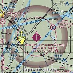
|
| Airport distance calculator |
|---|
|
|
| Sunrise and sunset |
|---|
|
Times for 31-May-2025
| | Local
(UTC-5) | | Zulu
(UTC) |
|---|
| Morning civil twilight | | 05:39 | | 10:39 |
| Sunrise | | 06:09 | | 11:09 |
| Sunset | | 20:44 | | 01:44 |
| Evening civil twilight | | 21:15 | | 02:15 |
|
| Current date and time |
|---|
| Zulu (UTC) | 31-May-2025 11:13:44 |
|---|
| Local (UTC-5) | 31-May-2025 06:13:44 |
|---|
|
| METAR |
|---|
| KEWK | 311056Z AUTO 20006KT 10SM CLR 14/13 A3001 RMK AO2 SLP153 T01390133
|
KAAO
19nm S | 311054Z AUTO 21006KT 10SM CLR 14/12 A3001 RMK AO2 SLP154 T01440117
|
|
| TAF |
|---|
KICT
26nm S | 310520Z 3106/0106 19004KT P6SM SKC FM311900 26007KT P6SM FEW200 PROB30 3120/0102 VRB25G40KT 3SM TSRA BKN030CB
|
KIAB
26nm S | 311000Z 3110/0116 21009KT 9999 SKC QNH2984INS BECMG 3123/3124 VRB15G25KT 8000 -TSRA BKN060CB OVC100 QNH2984INS TEMPO 0101/0104 VRB25G35KT OVC060 BECMG 0105/0106 35009KT 9999 NSW SCT100 BKN150 510003 QNH2991INS TX27/3121Z TN14/3112Z
|
KHUT
28nm W | 310520Z 3106/0106 VRB03KT P6SM SKC FM311500 25007KT P6SM FEW150 PROB30 3120/0101 VRB25G40KT 3SM TSRA BKN030CB
|
|
| NOTAMs |
|---|
NOTAMs are issued by the DoD/FAA and will open in a separate window not controlled by AirNav.
|
|


