FAA INFORMATION EFFECTIVE 14 MAY 2026
Location
| FAA Identifier: | 1K1 |
| Lat/Long: | 37-46-28.0000N 097-06-47.6000W
37-46.466667N 097-06.793333W
37.7744444,-97.1132222
(estimated) |
| Elevation: | 1364.1 ft. / 415.8 m (surveyed) |
| Variation: | 04E (2010) |
| From city: | 1 mile SW of BENTON, KS |
| Time zone: | UTC -5 (UTC -6 during Standard Time) |
| Zip code: | 67017 |
Airport Operations
| Airport use: | Open to the public |
| Activation date: | 10/1947 |
| Control tower: | no |
| ARTCC: | KANSAS CITY CENTER |
| FSS: | WICHITA FLIGHT SERVICE STATION |
| NOTAMs facility: | ICT (NOTAM-D service available) |
| Attendance: | UNATND |
| Wind indicator: | lighted |
| Segmented circle: | no |
| Lights: | SS-SR |
| Beacon: | white-green (lighted land airport)
Operates sunset to sunrise. |
Airport Communications
| CTAF/UNICOM: | 123.075 |
| WX AWOS-2: | 118.3 (316-530-6004) |
| WICHITA APPROACH: | 134.8 |
| WICHITA DEPARTURE: | 134.8 |
| CLEARANCE DELIVERY: | 125.0 |
| WX ASOS at AAO (5 nm W): | 134.025 (316-636-2541) |
| WX AWOS-3P at 3AU (6 nm S): | 124.175 (316-733-6696) |
| WX AWOS-3PT at BEC (7 nm SW): | 119.45 (316-515-7116) |
| WX AWOS-3P at EQA (14 nm E): | 120.875 (316-322-8095) |
| WX ASOS at ICT (17 nm SW): | PHONE 316-800-1006 |
| WX AWOS-3PT at EWK (19 nm NW): | 123.875 (316-283-8789) |
Nearby radio navigation aids
| VOR radial/distance | | VOR name | | Freq | | Var |
|---|
| ICTr079/22.4 | | WICHITA VORTAC | | 113.80 | | 07E |
Airport Services
| Fuel available: | 100LL JET-A+
100LL:100 LL 24 HR SELF SERVE. JET A+ REQ 24 HRS IN ADV. |
| Parking: | hangars and tiedowns |
Runway Information
Runway 17/35
| Dimensions: | 5106 x 75 ft. / 1556 x 23 m |
| Surface: | asphalt, in good condition |
| Runway edge lights: | high intensity |
| RUNWAY 17 | | RUNWAY 35 |
| Latitude: | 37-46.886218N | | 37-46.047055N |
| Longitude: | 097-06.831017W | | 097-06.755882W |
| Elevation: | 1364.1 ft. | | 1349.1 ft. |
| Traffic pattern: | right | | left |
| Runway heading: | 172 magnetic, 176 true | | 352 magnetic, 356 true |
| Displaced threshold: | 242 ft. | | no |
| Markings: | nonprecision, in good condition | | nonprecision, in good condition |
| Visual slope indicator: | 2-light PAPI on left (3.00 degrees glide path) | | |
| Touchdown point: | yes, no lights | | yes, no lights |
| Obstructions: | 47 ft. trees, 530 ft. from runway, 240 ft. right of centerline, 7:1 slope to clear
17 FT RD 38 FT DSTC, 125 FT L/R; 31 FT TREE, 1 FT DSTC, 190 FT R. | | 24 ft. hangar, 218 ft. right of centerline
24 FT HGR, 0-199 FT DSTC, 218 FT R; 23 FT WINDSOCK, 132 FT DSTC, 118 FT R. |
Airport Ownership and Management from official FAA records
| Ownership: | Privately-owned |
| Owner: | BENTON AIRPARK INC.
14789 SOUTHWEST 30TH. STREET
BENTON, KS 67017
Phone 316-636-9700 |
| Manager: | DWAYNE CLEMENS
14789 SOUTHWEST 30TH. STREET
BENTON, KS 67017
Phone 316-648-0132 |
Additional Remarks
| - | 70 FT WIDE CONC TWY TURN OFF MIDFIELD. |
| - | FOR CD CTC WICHITA APCH AT 316-350-1520. |
| - | UNCTLD VEHICLE TFC INVOF HANGARS & ON TWYS. BACK TAX ON RWY WHEN ABLE. |
| - | ULTRALIGHT ACFT PPR. |
| - | TWIN & LRGR BACK TAXI ON RWY. |
Instrument Procedures
NOTE: All procedures below are presented as PDF files. If you need a reader for these files, you should download the free Adobe Reader.NOT FOR NAVIGATION. Please procure official charts for flight.
FAA instrument procedures published for use from 14 May 2026 at 0901Z to 11 June 2026 at 0900Z.
IAPs - Instrument Approach Procedures |
|---|
| RNAV (GPS) RWY 17 | |
download (198KB) |
| NOTE: Special Take-Off Minimums/Departure Procedures apply | |
download (360KB) |
Other nearby airports with instrument procedures:
KAAO - Colonel James Jabara Airport (5 nm W)
3AU - Augusta Municipal Airport (6 nm S)
KBEC - Beech Factory Airport (7 nm SW)
KCEA - Cessna Aircraft Field Airport (10 nm SW)
KIAB - Mc Connell Air Force Base (12 nm SW)
K50 - Cook Airfield (13 nm S)
KEQA - El Dorado/Capt Jack Thomas Memorial Airport (14 nm E)
KICT - Wichita Dwight D Eisenhower National Airport (17 nm SW)
KEWK - Newton City/County Airport (19 nm NW)
|
|

Road maps at:
MapQuest
Bing
Google
| Aerial photo |
|---|
WARNING: Photo may not be current or correct
 Photo by Herb Pello
Photo taken 07-Nov-2012
looking south.
Photo by Herb Pello
Photo taken 07-Nov-2012
looking south.
Do you have a better or more recent aerial photo of Lloyd Stearman Field Airport that you would like to share? If so, please send us your photo.
|
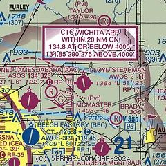
| Sectional chart |
|---|
|
| Airport distance calculator |
|---|
|
|
| Sunrise and sunset |
|---|
|
Times for 25-May-2026
| | Local
(UTC-5) | | Zulu
(UTC) |
|---|
| Morning civil twilight | | 05:42 | | 10:42 |
| Sunrise | | 06:12 | | 11:12 |
| Sunset | | 20:38 | | 01:38 |
| Evening civil twilight | | 21:09 | | 02:09 |
|
| Current date and time |
|---|
| Zulu (UTC) | 25-May-2026 14:02:54 |
|---|
| Local (UTC-5) | 25-May-2026 09:02:54 |
|---|
|
| METAR |
|---|
KAAO
5nm W | 251254Z AUTO 16008KT 10SM CLR 19/15 A3006 RMK AO2 SLP170 T01940150
|
K3AU
6nm S | 251335Z AUTO 14006KT 10SM CLR 20/13 A3008 RMK AO2
|
KBEC
7nm SW | 251355Z AUTO 16008KT 10SM CLR 21/15 A3008 RMK AO2 T02140152
|
KIAB
12nm SW | 251255Z AUTO 18007KT 10SM CLR 20/16 A3005 RMK AO2 SLP166 T02010155 $
|
KEQA
14nm E | 251355Z AUTO 16009KT 10SM CLR 23/16 A3009 RMK AO2
|
KICT
17nm SW | 251353Z 17008KT 10SM FEW150 FEW220 22/16 A3007 RMK AO2 SLP171 T02220161 $
|
KEWK
17nm NW | 251356Z AUTO 17009KT 10SM CLR 22/16 A3009 RMK AO2 SLP177 T02170161 $
|
|
| TAF |
|---|
KIAB
12nm SW | 250900Z 2509/2615 17009KT 9999 FEW250 QNH2996INS BECMG 2521/2522 16010G15KT 9999 FEW250 QNH2995INS BECMG 2600/2601 14009KT 9999 SKC QNH2995INS TX30/2521Z TN15/2512Z
|
KICT
17nm SW | 251120Z 2512/2612 VRB05KT P6SM FEW250 FM251500 17007KT P6SM SKC FM252300 14011KT P6SM FEW250
|
|
| NOTAMs |
|---|
NOTAMs are issued by the DoD/FAA and will open in a separate window not controlled by AirNav.
|
|

