FAA INFORMATION EFFECTIVE 25 DECEMBER 2025
Location
| FAA Identifier: | F56 |
| Lat/Long: | 32-54-37.7000N 099-44-03.0000W
32-54.628333N 099-44.050000W
32.9104722,-99.7341667
(estimated) |
| Elevation: | 1560.8 ft. / 475.7 m (surveyed) |
| Variation: | 06E (2010) |
| From city: | 4 miles SE of STAMFORD, TX |
| Time zone: | UTC -6 (UTC -5 during Daylight Saving Time) |
| Zip code: | 79503 |
Airport Operations
| Airport use: | Open to the public |
| Activation date: | 09/1941 |
| Control tower: | no |
| ARTCC: | FORT WORTH CENTER |
| FSS: | FORT WORTH FLIGHT SERVICE STATION |
| NOTAMs facility: | FTW (NOTAM-D service available) |
| Attendance: | UNATNDD |
| Wind indicator: | lighted |
| Segmented circle: | yes |
| Lights: | ACTVT MIRL RWY 17/35 - CTAF. |
| Beacon: | white-green (lighted land airport)
Operates sunset to sunrise. |
Airport Communications
| CTAF/UNICOM: | 122.8 |
| ABILENE APPROACH: | 127.2 |
| ABILENE DEPARTURE: | 127.2 |
Nearby radio navigation aids
| VOR radial/distance | | VOR name | | Freq | | Var |
|---|
| ABIr004/26.6 | | ABILENE VORTAC | | 113.70 | | 10E |
Airport Services
| Fuel available: | 100LL |
| Parking: | hangars and tiedowns |
| Airframe service: | MAJOR |
| Powerplant service: | MAJOR |
| Bottled oxygen: | NONE |
| Bulk oxygen: | NONE |
Runway Information
Runway 17/35
| Dimensions: | 3707 x 60 ft. / 1130 x 18 m |
| Surface: | asphalt, in good condition |
| Weight bearing capacity: | |
| Runway edge lights: | medium intensity |
| RUNWAY 17 | | RUNWAY 35 |
| Latitude: | 32-54.854227N | | 32-54.243023N |
| Longitude: | 099-44.157137W | | 099-44.162220W |
| Elevation: | 1560.6 ft. | | 1553.8 ft. |
| Traffic pattern: | left | | left |
| Runway heading: | 174 magnetic, 180 true | | 354 magnetic, 000 true |
| Markings: | nonprecision, in good condition | | nonprecision, in good condition |
| Touchdown point: | yes, no lights | | yes, no lights |
| Obstructions: | 15 ft. road, 860 ft. from runway, 44:1 slope to clear
10 FT ROAD 60 FT EAST OF RWY CNTRLN AT THR. | | none |
Runway 8/26
| Dimensions: | 2211 x 50 ft. / 674 x 15 m |
| Surface: | turf, in poor condition
RWY SFC ROUGH. |
| RUNWAY 8 | | RUNWAY 26 |
| Latitude: | 32-54.747442N | | 32-54.741275N |
| Longitude: | 099-44.163825W | | 099-43.731750W |
| Elevation: | 1560.0 ft. | | 1554.9 ft. |
| Traffic pattern: | left | | left |
| Runway heading: | 085 magnetic, 091 true | | 265 magnetic, 271 true |
| Touchdown point: | yes, no lights | | yes, no lights |
Runway 13/31
| Dimensions: | 1702 x 50 ft. / 519 x 15 m |
| Surface: | turf/gravel, in poor condition
RWY SFC ROUGH. |
| RUNWAY 13 | | RUNWAY 31 |
| Latitude: | 32-54.751265N | | 32-54.550128N |
| Longitude: | 099-44.057410W | | 099-43.825367W |
| Elevation: | 1558.0 ft. | | 1552.5 ft. |
| Traffic pattern: | left | | left |
| Runway heading: | 130 magnetic, 136 true | | 310 magnetic, 316 true |
| Touchdown point: | yes, no lights | | yes, no lights |
| Obstructions: | 10 ft. road | | 10 ft. road |
Airport Ownership and Management from official FAA records
| Ownership: | Publicly-owned |
| Owner: | CITY OF STAMFORD
201 E. MC HARG, PO BOX 191
STAMFORD, TX 79553
Phone 325-773-2591 |
| Manager: | ALAN PLUMLEE
201 E. MC HARG, PO BOX 191
STAMFORD, TX 79553
Phone 325-773-2591
CITY MANAGER |
Additional Remarks
| - | FARM EQUIPMENT INVOF AIRPORT. |
| - | FOR CD CTC FORT WORTH ARTCC AT 817-858-7584. |
Instrument Procedures
NOTE: All procedures below are presented as PDF files. If you need a reader for these files, you should download the free Adobe Reader.NOT FOR NAVIGATION. Please procure official charts for flight.
FAA instrument procedures published for use from 25 December 2025 at 0901z to 22 January 2026 at 0900z.
IAPs - Instrument Approach Procedures |
|---|
| RNAV (GPS) RWY 17 | |
download (189KB) |
| RNAV (GPS) RWY 35 | |
download (206KB) |
| NOTE: Special Take-Off Minimums/Departure Procedures apply | |
download (300KB) |
Other nearby airports with instrument procedures:
15F - Haskell Municipal Airport (17 nm N)
T23 - Albany Municipal Airport (26 nm SE)
KABI - Abilene Regional Airport (30 nm S)
KDYS - Dyess Air Force Base (30 nm S)
KBKD - Stephens County Airport (44 nm E)
|
|

Road maps at:
MapQuest
Bing
Google
| Aerial photo |
|---|
WARNING: Photo may not be current or correct
 Photo by John McDonald
Taken in 2007
Photo by John McDonald
Taken in 2007
Do you have a better or more recent aerial photo of Arledge Field Airport that you would like to share? If so, please send us your photo.
|
| Sectional chart |
|---|
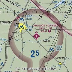
|
| Airport distance calculator |
|---|
|
|
| Sunrise and sunset |
|---|
|
Times for 28-Dec-2025
| | Local
(UTC-6) | | Zulu
(UTC) |
|---|
| Morning civil twilight | | 07:14 | | 13:14 |
| Sunrise | | 07:42 | | 13:42 |
| Sunset | | 17:39 | | 23:39 |
| Evening civil twilight | | 18:07 | | 00:07 |
|
| Current date and time |
|---|
| Zulu (UTC) | 29-Dec-2025 02:43:18 |
|---|
| Local (UTC-6) | 28-Dec-2025 20:43:18 |
|---|
|
| METAR |
|---|
KABI
30nm S | 290152Z 02018G33KT 10SM CLR 09/M04 A3029 RMK AO2 PK WND 02033/0147 SLP248 T00891044
|
KDYS
30nm S | 290155Z AUTO 03014G22KT 10SM OVC170 09/M05 A3027 RMK AO2 PK WND 04029/0056 SLP245 T00891047
|
KBKD
44nm E | 290215Z AUTO 02010G18KT CLR 09/M04 A3030 RMK AO2 T00931042
|
KSWW
46nm SW | 290215Z AUTO 04015G22KT 10SM 08/M05 A3031 RMK AO2 T00761048
|
KGZN
49nm SE | 290215Z AUTO 36016KT 10SM FEW042 OVC050 08/M04 A3026 RMK AO2
|
|
| TAF |
|---|
KABI
30nm S | 281735Z 2818/2918 32014G22KT P6SM SCT250 FM282200 36025G33KT P6SM BKN250 FM290300 01017G24KT P6SM BKN250 FM290700 01013KT P6SM SCT100 OVC250 FM291400 35015G23KT P6SM OVC100
|
KDYS
30nm S | 290100Z 2901/3007 03015G25KT 9999 BKN150 QNH3026INS BECMG 2910/2911 36012G18KT 9999 BKN120 QNH3045INS BECMG 2914/2915 36015G25KT 9999 BKN120 QNH3051INS BECMG 2919/2920 35012G18KT 9999 BKN120 QNH3049INS BECMG 2922/2923 35009KT 9999 BKN120 QNH3051INS TX10/2901Z TN01/2914Z
|
|
| NOTAMs |
|---|
NOTAMs are issued by the DoD/FAA and will open in a separate window not controlled by AirNav.
|
|

