FAA INFORMATION EFFECTIVE 17 APRIL 2025
Location
| FAA Identifier: | K34 |
| Lat/Long: | 38-48-24.6540N 094-57-24.2980W
38-48.410900N 094-57.404967W
38.8068483,-94.9567494
(estimated) |
| Elevation: | 1040 ft. / 317 m (estimated) |
| Variation: | 05E (1990) |
| From city: | 1 mile W of GARDNER, KS |
| Time zone: | UTC -5 (UTC -6 during Standard Time) |
| Zip code: | 66030 |
Airport Operations
| Airport use: | Open to the public |
| Activation date: | 05/1941 |
| Control tower: | no |
| ARTCC: | KANSAS CITY CENTER |
| FSS: | COLUMBIA FLIGHT SERVICE STATION |
| NOTAMs facility: | COU (NOTAM-D service available) |
| Attendance: | MON-FRI 0800-1600 |
| Wind indicator: | lighted |
| Segmented circle: | no |
| Lights: | SS-SR |
| Beacon: | white-green (lighted land airport)
Operates sunset to sunrise. |
Airport Communications
| CTAF/UNICOM: | 122.8 |
| KANSAS CITY APPROACH: | 118.9 |
| KANSAS CITY DEPARTURE: | 118.9 |
| WX ASOS at IXD (3 nm NE): | 135.325 (913-780-6987) |
| WX ASOS at OJC (11 nm E): | PHONE 913-780-6969 |
| WX ASOS at LWC (17 nm NW): | 121.225 (785-749-1309) |
Nearby radio navigation aids
| VOR radial/distance | | VOR name | | Freq | | Var |
|---|
| MCIr195/30.5 | | KANSAS CITY VORTAC | | 113.25 | | 05E |
| TOPr121/34.0 | | TOPEKA VORTAC | | 117.80 | | 05E |
| BUMr319/38.9 | | BUTLER VORTAC | | 115.90 | | 07E |
| NDB name | | Hdg/Dist | | Freq | | Var | | ID |
|---|
| HERBB | | 283/10.8 | | 420 | | 04E | | PK | .--. -.- |
| NEWBN | | 121/11.2 | | 338 | | 04E | | JZ | .--- --.. |
Airport Services
| Fuel available: | 100LL |
| Parking: | tiedowns |
| Airframe service: | MAJOR |
| Powerplant service: | MAJOR |
Runway Information
Runway 8/26
| Dimensions: | 2399 x 36 ft. / 731 x 11 m |
| Surface: | asphalt, in fair condition |
| Weight bearing capacity: | | PCN 3 /F/C/Y/U | | Single wheel: | 6.0 |
|
| Runway edge lights: | low intensity
NSTD LIRL 35 FT OUTBOARD OF RWY 240 FT SPACINGS. RWY 8 END, ONE LIGHT EACH SIDE OF RWY, RWY 26 END, THREE LIGHTS OUTBOARD EACH SIDE. |
| RUNWAY 8 | | RUNWAY 26 |
| Latitude: | 38-48.597000N | | 38-48.596333N |
| Longitude: | 094-57.518333W | | 094-57.013167W |
| Elevation: | 1029.7 ft. | | 1033.4 ft. |
| Traffic pattern: | left | | left |
| Runway heading: | 085 magnetic, 090 true | | 265 magnetic, 270 true |
| Markings: | basic, in good condition | | basic, in good condition |
| Touchdown point: | yes, no lights | | yes, no lights |
| Obstructions: | 3 ft. fence, 311 ft. from runway, 37:1 slope to clear | | none |
Runway 17/35
| Dimensions: | 3224 x 60 ft. / 983 x 18 m |
| Surface: | turf, in good condition |
| Runway edge lights: | low intensity
RWY END LGTS NA. |
| Runway edge markings: | ORANGE BARRELS. |
| RUNWAY 17 | | RUNWAY 35 |
| Latitude: | 38-48.586000N | | 38-48.054833N |
| Longitude: | 094-57.527333W | | 094-57.522500W |
| Elevation: | 1029.0 ft. | | 1040.0 ft. |
| Traffic pattern: | left | | left |
| Runway heading: | 175 magnetic, 180 true | | 355 magnetic, 000 true |
| Markings: | NSTD, in good condition | | NSTD, in good condition |
| Obstructions: | 26 ft. tree, 512 ft. from runway, 15 ft. left of centerline, 19:1 slope to clear | | 67 ft. trees, 775 ft. from runway, 102 ft. left of centerline, 11:1 slope to clear |
Runway 3/21
| Dimensions: | 1871 x 60 ft. / 570 x 18 m |
| Surface: | turf, in good condition |
| RUNWAY 3 | | RUNWAY 21 |
| Latitude: | 38-48.200833N | | 38-48.456333N |
| Longitude: | 094-57.486833W | | 094-57.266667W |
| Elevation: | 1032.0 ft. | | 1031.0 ft. |
| Traffic pattern: | left | | left |
| Runway heading: | 029 magnetic, 034 true | | 209 magnetic, 214 true |
| Markings: | numbers only, in poor condition | | numbers only, in poor condition |
| Touchdown point: | yes, no lights | | yes, no lights |
| Obstructions: | 40 ft. tree, 420 ft. from runway, 115 ft. left of centerline, 10:1 slope to clear
+31 FT TREES R EDGE OF RWY 400 FT FM RWY END. | | none |
Airport Ownership and Management from official FAA records
| Ownership: | Publicly-owned |
| Owner: | CITY OF GARDNER
CITY HALL, 120 E MAIN ST.
GARDNER, KS 66030
Phone 913-856-0914 |
| Manager: | KELLEN HEADLEE
120 E. MAIN ST., 31905 W 175 ST
GARDNER, KS 66030
Phone 913-856-0914 |
Additional Remarks
| - | GLIDER & ULTRALIGHT ACT ON & INVOF ARPT. |
| - | FUEL 24 HRS SELF-SERVE. |
| - | FOR CD CTC KANSAS CITY APCH AT 816-329-2710. |
| - | ACES RWY 17 THR VIA RWY 8 OVRN. |
Instrument Procedures
There are no published instrument procedures at K34.
Some nearby airports with instrument procedures:
KIXD - New Century AirCenter Airport (3 nm NE)
KOJC - Johnson County Executive Airport (11 nm E)
K81 - Miami County Airport (16 nm S)
KLWC - Lawrence Regional Airport (17 nm NW)
KOWI - Ottawa Municipal Airport (21 nm SW)
|
|

Road maps at:
MapQuest
Bing
Google
| Aerial photo |
|---|
WARNING: Photo may not be current or correct
 © Jon Blumb Aerial Photography
Photo taken 27-Jun-2009
© Jon Blumb Aerial Photography
Photo taken 27-Jun-2009
Do you have a better or more recent aerial photo of Gardner Municipal Airport that you would like to share? If so, please send us your photo.
|
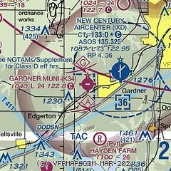
| Sectional chart |
|---|
|
| Airport distance calculator |
|---|
|
|
| Sunrise and sunset |
|---|
|
Times for 25-Apr-2025
| | Local
(UTC-5) | | Zulu
(UTC) |
|---|
| Morning civil twilight | | 06:02 | | 11:02 |
| Sunrise | | 06:31 | | 11:31 |
| Sunset | | 20:05 | | 01:05 |
| Evening civil twilight | | 20:33 | | 01:33 |
|
| Current date and time |
|---|
| Zulu (UTC) | 26-Apr-2025 04:33:03 |
|---|
| Local (UTC-5) | 25-Apr-2025 23:33:03 |
|---|
|
| METAR |
|---|
KIXD
3nm E | 260353Z AUTO 35010KT 10SM OVC020 14/10 A3021 RMK AO2 SLP227 T01390100
|
KOJC
11nm E | 260353Z AUTO 35008KT 10SM OVC019 14/10 A3020 RMK AO2 SLP223 T01390100
|
KLWC
17nm NW | 260352Z AUTO 34005KT 10SM OVC023 13/11 A3022 RMK AO1 SLP233 T01330106
|
KGVW
18nm E | 260415Z AUTO 11012KT 6SM BR FEW011 SCT017 BKN029 24/23 A3007 RMK A01
|
|
| TAF |
|---|
KIXD
3nm E | 251730Z 2518/2618 36011KT P6SM BKN018 FM260700 05008KT P6SM BKN018
|
|
| NOTAMs |
|---|
NOTAMs are issued by the DoD/FAA and will open in a separate window not controlled by AirNav.
|
|


