FAA INFORMATION EFFECTIVE 17 APRIL 2025
Location
| FAA Identifier: | CAE |
| Lat/Long: | 33-56-19.8160N 081-07-10.3300W
33-56.330267N 081-07.172167W
33.9388378,-81.1195361
(estimated) |
| Elevation: | 236 ft. / 71.9 m (surveyed) |
| Variation: | 07W (2020) |
| From city: | 5 miles SW of COLUMBIA, SC |
| Time zone: | UTC -4 (UTC -5 during Standard Time) |
| Zip code: | 29170 |
Airport Operations
| Airport use: | Open to the public |
| Activation date: | 06/1942 |
| Control tower: | yes |
| ARTCC: | JACKSONVILLE CENTER |
| FSS: | ANDERSON FLIGHT SERVICE STATION |
| NOTAMs facility: | CAE (NOTAM-D service available) |
| Attendance: | CONTINUOUS |
| Wind indicator: | lighted |
| Segmented circle: | no |
| Lights: | SS-SR |
| Beacon: | white-green (lighted land airport)
Operates sunset to sunrise. |
| Fire and rescue: | ARFF index B |
| International operations: | customs landing rights airport |
Airport Communications
| UNICOM: | 122.95 |
| ATIS: | 120.15 |
| WX ASOS: | 120.15 (803-369-6879) |
| COLUMBIA GROUND: | 121.9 348.6 |
| COLUMBIA TOWER: | 119.5 257.8 |
| COLUMBIA APPROACH: | 124.15 ;110-289 133.4 ;290-109 285.6 ;290-109 338.2 ;110-289 |
| COLUMBIA DEPARTURE: | 124.15 ;110-289 133.4 ;290-109 285.6 ;290-109 338.2 ;110-289 |
| CLEARANCE DELIVERY: | 119.75 |
| CLASS C: | 124.15 ;110-289 133.4 ;290-109 285.6 ;290-109 338.2 ;110-289 |
| EMERG: | 121.5 243.0 |
| IC: | 124.15 ;110-289 133.4 ;290-109 285.6 ;290-109 338.2 ;110-289 |
| WX ASOS at CUB (6 nm E): | 118.675 (803-929-0665) |
Nearby radio navigation aids
| VOR radial/distance | | VOR name | | Freq | | Var |
|---|
| CAEr328/5.9 | | COLUMBIA VORTAC | | 114.70 | | 02W |
| MMTr281/15.8 | | MC ENTIRE VORTAC | | 113.20 | | 08W |
| NDB name | | Hdg/Dist | | Freq | | Var | | ID |
|---|
| AIKEN | | 064/32.7 | | 347 | | 06W | | AIK | .- .. -.- |
| ENOREE | | 138/34.0 | | 278 | | 07W | | EOE | . --- . |
| SUMTER | | 272/37.9 | | 252 | | 07W | | SMS | ... -- ... |
Airport Services
| Fuel available: | 100LL JET-A |
| Parking: | hangars and tiedowns |
| Airframe service: | MAJOR |
| Powerplant service: | MAJOR |
| Bottled oxygen: | HIGH |
| Bulk oxygen: | HIGH |
Runway Information
Runway 11/29
| Dimensions: | 8601 x 150 ft. / 2622 x 46 m
RWY 11 220 FT BY 400 FT BLAST PAD; RWY 29 220 FT BY 400 FT BLAST PAD. |
| Surface: | concrete/grooved, in excellent condition |
| Weight bearing capacity: | | Single wheel: | 120.0 | | Double wheel: | 239.0 | | Double tandem: | 478.0 | | Dual double tandem: | 700.0 |
|
| Runway edge lights: | high intensity |
| RUNWAY 11 | | RUNWAY 29 |
| Latitude: | 33-56.648860N | | 33-56.289908N |
| Longitude: | 081-08.265218W | | 081-06.619265W |
| Elevation: | 228.7 ft. | | 210.0 ft. |
| Traffic pattern: | left | | left |
| Runway heading: | 112 magnetic, 105 true | | 292 magnetic, 285 true |
| Declared distances: | TORA:8601 TODA:8601 ASDA:8601 LDA:8601 | | TORA:8601 TODA:8601 ASDA:8506 LDA:8506 |
| Markings: | precision, in good condition | | precision, in good condition |
| Visual slope indicator: | 4-light PAPI on left (3.00 degrees glide path) | | 4-light PAPI on left (3.00 degrees glide path) |
| RVR equipment: | touchdown, midfield, rollout | | touchdown, midfield, rollout |
| Approach lights: | ALSF2: standard 2,400 foot high intensity approach lighting system with centerline sequenced flashers (category II or III)
ALSF2 ALSO OPERS AS SSALR. | | MALSR: 1,400 foot medium intensity approach lighting system with runway alignment indicator lights |
| Centerline lights: | yes | | yes |
| Touchdown point: | yes, lighted | | yes, no lights |
| Instrument approach: | ILS/DME | | ILS |
Runway 5/23
| Dimensions: | 8001 x 150 ft. / 2439 x 46 m
RWY 05 200 FT BY 200 FT BLAST PAD. |
| Surface: | asphalt/concrete/grooved, in excellent condition
RWY 05/23 CNTR 75 FT IS CONC, ENTIRE LEN OF RWY. |
| Weight bearing capacity: | | Single wheel: | 120.0 | | Double wheel: | 242.0 | | Double tandem: | 487.0 | | Dual double tandem: | 675.0 |
|
| Runway edge lights: | high intensity |
| RUNWAY 5 | | RUNWAY 23 |
| Latitude: | 33-55.711493N | | 33-56.649785N |
| Longitude: | 081-07.437993W | | 081-06.325642W |
| Elevation: | 227.5 ft. | | 206.8 ft. |
| Traffic pattern: | left | | left |
| Runway heading: | 052 magnetic, 045 true | | 232 magnetic, 225 true |
| Displaced threshold: | no | | 1000 ft. |
| Declared distances: | TORA:8001 TODA:8001 ASDA:7001 LDA:7001 | | TORA:8001 TODA:8001 ASDA:8001 LDA:7001 |
| Markings: | precision, in good condition | | precision, in good condition |
| Visual slope indicator: | 4-light PAPI on right (3.00 degrees glide path) | | 4-light PAPI on left (3.00 degrees glide path) |
| RVR equipment: | touchdown | | touchdown |
| Approach lights: | MALSR: 1,400 foot medium intensity approach lighting system with runway alignment indicator lights | | |
| Runway end identifier lights: | | | yes |
| Touchdown point: | yes, no lights | | yes, no lights |
| Instrument approach: | ILS | | |
| Obstructions: | none | | 45 ft. tree, 1575 ft. from runway, 100 ft. left of centerline, 33:1 slope to clear |
Helipad H1
| Dimensions: | 50 x 50 ft. / 15 x 15 m |
| Surface: | concrete, in fair condition |
| Runway edge lights: | PERI |
| Latitude: | 33-56.525000N | | |
| Longitude: | 081-06.707167W | | |
| Elevation: | 236.0 ft. | | |
| Traffic pattern: | left | | left |
| Markings: | none, in fair condition | | |
Airport Ownership and Management from official FAA records
| Ownership: | Publicly-owned |
| Owner: | RICHLAND LEXINGTON
3250 AIRPORT BLVD, SUITE 10
WEST COLUMBIA, SC 29170
Phone 803-822-5050
ARPT DIST. |
| Manager: | RYAN KREULEN
3250 AIRPORT BLVD, SUITE 10
WEST COLUMBIA, SC 29170
Phone (803) 822-5017 |
Additional Remarks
| A39-05/23 | PCR VALUE: 750/R/A/W/T |
| A39-11/29 | PCR VALUE: 740/R/A/W/T |
| - | FEE FOR COML ACFT OVER 15000 LBS. |
| - | HELIPAD H1 LOCATED NORTH OF TAXILANE E, EAST OF TWY E3. |
| - | DUE TO PROXIMITY AND RWY ALNMT AIRCREWS HAVE MISTAKEN CUB (RWY 13/31) FOR CAE (RWY 11/29) WHICH IS 6 MILES NE. |
| - | OPRN OF ULTRALIGHT VEHICLES PROHIBITED. |
| - | SPORTS COMPLEX WITH NMRS FLOOD LGTS APRXLY 6500 FT FROM APCH END RWY 11. |
| - | NOISE ABATEMENT PROC: NO TURNS BLW 1000 FT FOR TURBINE ENG ACFT UNLESS DCTD BY ATC. |
| - | ACFT LNDG WITH EXPLOSIVES OBTAIN PPR FM ARPT OPS 803-822-5050. |
Instrument Procedures
NOTE: All procedures below are presented as PDF files. If you need a reader for these files, you should download the free Adobe Reader.NOT FOR NAVIGATION. Please procure official charts for flight.
FAA instrument procedures published for use from 17 April 2025 at 0901Z to 15 May 2025 at 0900z.
IAPs - Instrument Approach Procedures |
|---|
| ILS OR LOC RWY 05 **CHANGED** | |
download (336KB) |
| ILS OR LOC RWY 11 | |
download (322KB) |
| ILS OR LOC RWY 29 **CHANGED** | |
download (275KB) |
| ILS RWY 11 (CAT II - III) | |
download (246KB) |
| RNAV (GPS) RWY 05 **CHANGED** | |
download (295KB) |
| RNAV (GPS) RWY 11 | |
download (254KB) |
| RNAV (GPS) RWY 23 | |
download (277KB) |
| RNAV (GPS) RWY 29 **CHANGED** | |
download (259KB) |
| VOR-A | |
download (198KB) |
| NOTE: Special Alternate Minimums apply **CHANGED** | |
download (169KB) |
| NOTE: Special Take-Off Minimums/Departure Procedures apply | |
download (355KB) |
Other nearby airports with instrument procedures:
KCUB - Jim Hamilton L B Owens Airport (6 nm E)
6J0 - Lexington County Airport (11 nm SW)
KMMT - Mc Entire Joint National Guard Base (16 nm E)
KXNO - North Air Force Auxiliary Field (20 nm S)
KFDW - Fairfield County Airport (23 nm N)
|
|

Road maps at:
MapQuest
Bing
Google
| Aerial photo |
|---|
WARNING: Photo may not be current or correct
 Photo by Grant Gordon
Photo taken 05-Apr-2012
looking north.
Photo by Grant Gordon
Photo taken 05-Apr-2012
looking north.
Do you have a better or more recent aerial photo of Columbia Metro Airport that you would like to share? If so, please send us your photo.
|
| Sectional chart |
|---|
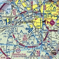
|
CAUTION: Diagram may not be current
 Download PDF
of official airport diagram from the FAA
| Airport distance calculator |
|---|
|
|
| Sunrise and sunset |
|---|
|
Times for 01-May-2025
| | Local
(UTC-4) | | Zulu
(UTC) |
|---|
| Morning civil twilight | | 06:10 | | 10:10 |
| Sunrise | | 06:36 | | 10:36 |
| Sunset | | 20:07 | | 00:07 |
| Evening civil twilight | | 20:33 | | 00:33 |
|
| Current date and time |
|---|
| Zulu (UTC) | 01-May-2025 17:59:58 |
|---|
| Local (UTC-4) | 01-May-2025 13:59:58 |
|---|
|
| METAR |
|---|
| KCAE | 011656Z VRB06KT 10SM FEW050 SCT220 28/15 A3009 RMK AO2 SLP185 T02780150
|
KCUB
6nm E | 011753Z AUTO 17008KT 10SM CLR 29/13 A3008 RMK AO2 SLP183 T02890133 10294 20183 58020
|
KMMT
17nm E | 011755Z 19009KT 10SM FEW040 SCT200 29/12 A3006 RMK AO2A SLP180 T02920117 10292 20180 57019 $
|
KXNO
20nm S | 011755Z AUTO 18006KT 10SM CLR 29/13 A3007 RMK AO2 SLP183 T02910125 10294 20176 57019 $
|
|
| TAF |
|---|
| KCAE | 011737Z 0118/0218 19011KT P6SM SCT050 SCT200 FM020000 18004KT P6SM BKN120 FM021100 20006KT P6SM FEW050 BKN200
|
KCUB
6nm E | 011737Z 0118/0218 18008KT P6SM SCT050 SCT200 FM020000 VRB03KT P6SM BKN120 FM021100 20005KT P6SM FEW050 BKN200
|
KMMT
17nm E | 011500Z 0115/0219 22009KT 9999 SKC QNH3016INS BECMG 0122/0200 20006KT 9999 RA SCT040 QNH3004INS BECMG 0203/0204 VRB06KT 9999 NSW SCT035 QNH3008INS TX27/0120Z TN18/0211Z
|
|
| NOTAMs |
|---|
NOTAMs are issued by the DoD/FAA and will open in a separate window not controlled by AirNav.
|
|


