FAA INFORMATION EFFECTIVE 19 FEBRUARY 2026
Location
| FAA Identifier: | CCR |
| Lat/Long: | 37-59-22.7640N 122-03-24.8480W
37-59.379400N 122-03.414133W
37.9896567,-122.0569022
(estimated) |
| Elevation: | 25.6 ft. / 7.8 m (surveyed) |
| Variation: | 13E (2020) |
| From city: | 1 mile W of CONCORD, CA |
| Time zone: | UTC -8 (UTC -7 during Daylight Saving Time) |
| Zip code: | 94520 |
Airport Operations
| Airport use: | Open to the public |
| Activation date: | 07/1944 |
| Control tower: | yes |
| ARTCC: | OAKLAND CENTER |
| FSS: | OAKLAND FLIGHT SERVICE STATION |
| NOTAMs facility: | CCR (NOTAM-D service available) |
| Attendance: | 0700-1700 |
| Wind indicator: | lighted |
| Segmented circle: | yes |
| Lights: | ACTVT MALS RWY 19R 2200-0600; PAPI RWY 01L, 19R, & 32R - 119.7. REIL RWY 01L OFF WHEN ATCT CLSD. |
| Beacon: | white-green (lighted land airport)
Operates sunset to sunrise. |
| Fire and rescue: | ARFF index A |
| Airline operations: | CLSD TO ACR OPNS WITH MORE THAN 30 PSGR SEATS EXC PPR; CALL AMGR (925) 681-4200. ARFF SVCS AVBL 24 HRS WITH PRIOR APVL FROM ARPT ADMIN. |
Airport Communications
| CTAF: | 119.7 |
| UNICOM: | 122.95 |
| ATIS: | 124.7 |
| WX ASOS: | PHONE 925-689-2077 |
| CONCORD GROUND: | 121.9 [0700-2200] |
| CONCORD TOWER: | 119.7 123.9 257.8 [0700-2200] |
| TRAVIS APPROACH: | 119.9 |
| TRAVIS DEPARTURE: | 119.9 |
| CLEARANCE DELIVERY: | 118.025 |
| BMBER STAR: | 119.9 ;SOUTH 124.8 |
| EMERG: | 121.5 |
| IC: | 119.7 |
| WX ASOS at APC (17 nm NW): | PHONE 707-252-7916 |
| WX ASOS at OAK (18 nm SW): | PHONE 510-214-1776 |
Nearby radio navigation aids
| VOR radial/distance | | VOR name | | Freq | | Var |
|---|
| CCRr172/3.4 | | CONCORD VOR/DME | | 117.00 | | 17E |
| OAKr010/17.7 | | OAKLAND VOR/DME | | 116.80 | | 17E |
| SGDr110/18.8 | | SCAGGS ISLAND VORTAC | | 112.10 | | 17E |
| SAUr053/23.5 | | SAUSALITO VOR/DME | | 116.20 | | 17E |
| SFOr017/26.8 | | SAN FRANCISCO VOR/DME | | 115.80 | | 17E |
| SACr204/36.2 | | SACRAMENTO VORTAC | | 115.20 | | 17E |
| SJCr336/37.3 | | SAN JOSE VOR/DME | | 114.10 | | 16E |
| OSIr360/37.4 | | WOODSIDE VOR/DME | | 113.90 | | 17E |
| PYEr081/38.7 | | POINT REYES VOR/DME | | 113.70 | | 17E |
Airport Services
| Fuel available: | 100LL JET-A1+ |
| Parking: | tiedowns |
| Airframe service: | MAJOR |
| Powerplant service: | MAJOR |
| Bottled oxygen: | NONE |
| Bulk oxygen: | HIGH/LOW |
Runway Information
Runway 1L/19R
| Dimensions: | 5001 x 150 ft. / 1524 x 46 m |
| Surface: | asphalt/concrete/grooved, in good condition |
| Weight bearing capacity: | | Single wheel: | 83.0 | | Double wheel: | 121.0 | | Double tandem: | 189.0 |
|
| Runway edge lights: | high intensity |
| RUNWAY 1L | | RUNWAY 19R |
| Latitude: | 37-58.917230N | | 37-59.672700N |
| Longitude: | 122-03.679825W | | 122-03.264297W |
| Elevation: | 23.6 ft. | | 21.0 ft. |
| Traffic pattern: | left | | right
STD LEFT TFC WHEN ATCT CLSD. |
| Runway heading: | 011 magnetic, 024 true | | 191 magnetic, 204 true |
| Displaced threshold: | no | | 601 ft. |
| Declared distances: | TORA:4701 TODA:5001 ASDA:4401 LDA:4401 | | TORA:5001 TODA:5001 ASDA:5001 LDA:4401 |
| Markings: | precision, in good condition | | precision, in good condition |
| Visual slope indicator: | 4-light PAPI on left (4.00 degrees glide path)
PAPI DOES NOT PROVIDE OBSTRUCTION CLEARANCE BYD 4.0 NM FROM THR. | | 4-light PAPI on left (3.00 degrees glide path) |
| Approach lights: | | | MALS: 1,400 foot medium intensity approach lighting system |
| Runway end identifier lights: | yes | | no |
| Touchdown point: | yes, no lights | | yes, no lights |
| Instrument approach: | | | LDA/DME |
| Obstructions: | 58 ft. tree, 1480 ft. from runway, 550 ft. right of centerline, 22:1 slope to clear
RWY 01L CLOSE IN OBSTN +8 FT FENCE 110 FT FROM RWY END, 100 FT RT | | 44 ft. pole, 900 ft. from runway, 590 ft. left of centerline, 15:1 slope to clear |
Runway 14L/32R
| Dimensions: | 4602 x 150 ft. / 1403 x 46 m |
| Surface: | asphalt/concrete/grooved, in excellent condition |
| Weight bearing capacity: | | Single wheel: | 83.0 | | Double wheel: | 189.0 | | Double tandem: | 120.0 |
|
| Runway edge lights: | medium intensity |
| RUNWAY 14L | | RUNWAY 32R |
| Latitude: | 37-59.790885N | | 37-59.112172N |
| Longitude: | 122-03.531467W | | 122-03.104528W |
| Elevation: | 18.2 ft. | | 25.6 ft. |
| Traffic pattern: | left | | right |
| Runway heading: | 141 magnetic, 154 true | | 321 magnetic, 334 true |
| Displaced threshold: | 301 ft. | | 350 ft. |
| Declared distances: | TORA:4601 TODA:4601 ASDA:4001 LDA:3701 | | TORA:4601 TODA:5081 ASDA:4481 LDA:4131 |
| Markings: | nonprecision, in good condition | | nonprecision, in good condition |
| Visual slope indicator: | | | 4-light PAPI on right (4.00 degrees glide path)
PAPI DOES NOT PROVIDE OBSTRUCTION CLEARANCE BYD 4.0 NM FROM THR. |
| Runway end identifier lights: | no | | yes |
| Touchdown point: | yes, no lights | | yes, no lights |
| Obstructions: | 15 ft. road, 850 ft. from runway, 43:1 slope to clear
APCH RATIO 50:1 TO DSPLCD THR. | | 32 ft. tree, 1335 ft. from runway, 225 ft. right of centerline, 35:1 slope to clear
APCH RATIO 50:1 TO DSPLCD THR. |
Runway 14R/32L
| Dimensions: | 2798 x 75 ft. / 853 x 23 m |
| Surface: | asphalt, in fair condition |
| Weight bearing capacity: | | PCN 14 /F/B/W/T | | Single wheel: | 12.5 |
|
| Operational restrictions: | RWY 14R/32L NOT AVBL FOR PART 121/PART 380 OPS WITH SKED PAX CARRYING OPS MORE THAN 9 PAX SEATS AND NON-SKED PAX CARRYING OPS MORE THAN 30 PAX SEATS. |
| RUNWAY 14R | | RUNWAY 32L |
| Latitude: | 37-59.754013N | | 37-59.341450N |
| Longitude: | 122-03.624712W | | 122-03.364970W |
| Elevation: | 17.1 ft. | | 22.2 ft. |
| Traffic pattern: | right | | left |
| Runway heading: | 141 magnetic, 154 true | | 321 magnetic, 334 true |
| Declared distances: | TORA:2799 TODA:2799 ASDA:2799 LDA:2799 | | TORA:2799 TODA:2799 ASDA:2799 LDA:2799 |
| Markings: | basic, in good condition | | basic, in good condition |
| Runway end identifier lights: | no | | no |
| Touchdown point: | yes, no lights | | yes, no lights |
| Obstructions: | 15 ft. road, 580 ft. from runway, 25:1 slope to clear
LIGHT | | 46 ft. other, 1260 ft. from runway, 175 ft. left of centerline, 23:1 slope to clear |
Runway 1R/19L
| Dimensions: | 2770 x 75 ft. / 844 x 23 m |
| Surface: | asphalt, in poor condition
RWY 01R/19L PAVEMENT HAS HIGH SEVERITY BLOCK CRACKING, LONGL AND TRANSVERSE CRACKING, PATCHING, AND WEATHERING. |
| Weight bearing capacity: | | PCN 12 /F/B/W/U | | Single wheel: | 17.0 |
|
| Operational restrictions: | RWY 01R/19L NOT AVBL FOR PART 121/PART 380 OPS WITH SKED PAX CARRYING OPS MORE THAN 9 PAX SEATS AND NON-SKED PAX CARRYING OPS MORE THAN 30 PAX SEATS. |
| RUNWAY 1R | | RUNWAY 19L |
| Latitude: | 37-59.032802N | | 37-59.451240N |
| Longitude: | 122-03.502907W | | 122-03.272613W |
| Elevation: | 23.5 ft. | | 21.7 ft. |
| Traffic pattern: | right | | left |
| Runway heading: | 011 magnetic, 024 true | | 191 magnetic, 204 true |
| Declared distances: | TORA:2770 TODA:2770 ASDA:2770 LDA:2770 | | TORA:2770 TODA:2770 ASDA:2770 LDA:2770 |
| Markings: | basic, in good condition | | basic, in good condition |
| Runway end identifier lights: | no | | no |
| Touchdown point: | yes, no lights | | yes, no lights |
| Obstructions: | 50 ft. tree, 1675 ft. from runway, 150 ft. right of centerline, 30:1 slope to clear | | 69 ft. tree, 2000 ft. from runway, 257 ft. left of centerline, 26:1 slope to clear |
Airport Ownership and Management from official FAA records
| Ownership: | Publicly-owned |
| Owner: | CONTRA COSTA COUNTY
181 JOHN GLENN DR, SUITE 100
CONCORD, CA 94520
Phone 925-608-8000 |
| Manager: | GREG BAER
181 JOHN GLENN DR, SUITE 100
CONCORD, CA 94520
Phone 925-608-8000 |
Additional Remarks
| A39-01L/19R | PCR VALUE: 330/F/C/X/T |
| A39-14L/32R | PCR VALUE: 330/F/C/X/T |
| - | ARPT HAS NOISE ABATEMENT PROCS; CTC AMGR PRIOR TO ARR 925-608-8000. |
| - | BIRDS ON & INVOF ARPT HEAVIEST CONCENTRATION NOV-MAR AND AFTER RAINSTORMS. |
| - | WHEN ATCT CLSD RYS 14L/32R; 14R/32L & 01R/19L CLSD. |
| - | NO TRAINING OPERATIONS MON-FRI 2200-0700; SAT SUN & HOL 2200-0800. |
| - | ARFF SVC AVBL UPON REQ WITH 24 HR NTC. |
| - | WHEN ATCT CLSD CALL TRAVIS APCH CTL (SUU) CLNC DEL 707-424-5111. |
| - | NOISE SENSITIVE AREA PRACTICE NOISE ABATEMENT (FLY QUIET) PROCS. |
| - | ARPT SFC CONDS NOT MNT 2200-0700. |
| - | CONTRA COSTA CO SUPVRS OF ARPT OPS, BUCHANAN FLD AND BYRON ARPTS, OFC CTC NR 925-608-8000. |
| - | LNDG FEE FOR COML OPNS & TIE DOWN FEE FOR OVERNIGHT PARKING. |
| - | +8 FT FENCE 110 FT BYD RY 01L TODA DSTC OF 5010 AND +7 FT FENCE 210 FT BYD RY 14L TODA DSTC OF 4601 FT ALONG THE EXTDD RY CNTRL. |
Instrument Procedures
NOTE: All procedures below are presented as PDF files. If you need a reader for these files, you should download the free Adobe Reader.NOT FOR NAVIGATION. Please procure official charts for flight.
FAA instrument procedures published for use from 19 February 2026 at 0901Z to 19 March 2026 at 0900Z.
STARs - Standard Terminal Arrivals |
|---|
| BMBER ONE (RNAV) | |
2 pages:
[1] [2] (335KB) |
IAPs - Instrument Approach Procedures |
|---|
| RNAV (GPS) RWY 19R **CHANGED** | |
download (272KB) |
| RNAV (GPS) RWY 19R **CHANGED** | |
download (272KB) |
| LDA RWY 19R **CHANGED** | |
download (330KB) |
| VOR RWY 19R **CHANGED** | |
download (305KB) |
| NOTE: Special Alternate Minimums apply | |
download (142KB) |
Departure Procedures |
|---|
| BUCHANAN TWO | |
download (258KB) |
| BUCHANAN TWO | |
download (258KB) |
| NOTE: Special Take-Off Minimums/Departure Procedures apply | |
download (355KB) |
Other nearby airports with instrument procedures:
KAPC - Napa County Airport (17 nm NW)
KSUU - Travis Air Force Base (18 nm N)
KOAK - Oakland San Francisco Bay Airport (18 nm SW)
KHWD - Hayward Executive Airport (20 nm S)
O88 - Rio Vista Municipal Airport (21 nm NE)
|
|

Road maps at:
MapQuest
Bing
Google
| Aerial photo |
|---|
WARNING: Photo may not be current or correct
 Photo by Srinath Nandakumar
Photo taken 08-Jul-2020
looking east.
Photo by Srinath Nandakumar
Photo taken 08-Jul-2020
looking east.
Do you have a better or more recent aerial photo of Buchanan Field Airport that you would like to share? If so, please send us your photo.
|
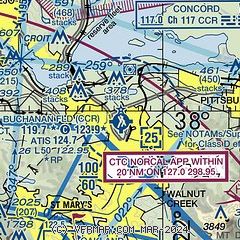
| Sectional chart |
|---|
|
CAUTION: Diagram may not be current
 Download PDF
of official airport diagram from the FAA
| Airport distance calculator |
|---|
|
|
| Sunrise and sunset |
|---|
|
Times for 03-Mar-2026
| | Local
(UTC-8) | | Zulu
(UTC) |
|---|
| Morning civil twilight | | 06:12 | | 14:12 |
| Sunrise | | 06:38 | | 14:38 |
| Sunset | | 18:02 | | 02:02 |
| Evening civil twilight | | 18:29 | | 02:29 |
|
| Current date and time |
|---|
| Zulu (UTC) | 03-Mar-2026 23:28:12 |
|---|
| Local (UTC-8) | 03-Mar-2026 15:28:12 |
|---|
|
| METAR |
|---|
| KCCR | 032253Z 31006KT 10SM FEW024 21/09 A3006 RMK AO2 SLP167 T02060094
|
KAPC
17nm NW | 032254Z 21006KT 10SM CLR 18/12 A3007 RMK AO2 SLP174 T01830122
|
KSUU
18nm N | 032255Z AUTO 22010KT 10SM CLR 21/13 A3004 RMK AO2 SLP179 T02090128 $
|
KOAK
19nm SW | 032253Z 27010KT 10SM FEW005 FEW030 SCT250 17/11 A3009 RMK AO2 SLP191 T01720111
|
KHWD
20nm S | 032254Z 28011KT 10SM CLR 17/11 A3008 RMK AO2 SLP196 T01720111
|
|
| TAF |
|---|
KAPC
17nm NW | 031734Z 0318/0418 25003KT 2SM BR BKN003 FM032000 25006KT P6SM BKN250 FM040900 27006KT P6SM BKN010
|
KSUU
18nm N | 031100Z 0311/0417 23009KT 9999 FEW010 QNH3007INS TEMPO 0314/0316 3200 BR BKN010 BECMG 0316/0317 23010G15KT 9999 FEW250 QNH3002INS BECMG 0406/0407 23010G15KT 8000 BR SCT010 BKN100 QNH3007INS TX23/0323Z TN06/0313Z
|
KOAK
19nm SW | 031734Z 0318/0424 36003KT P6SM FEW005 OVC010 FM032000 26008KT P6SM BKN250 FM040900 27008KT P6SM BKN015 FM042000 29012KT P6SM SKC
|
|
| NOTAMs |
|---|
NOTAMs are issued by the DoD/FAA and will open in a separate window not controlled by AirNav.
|
|


