FAA INFORMATION EFFECTIVE 15 MAY 2025
Location
| FAA Identifier: | GEG |
| Lat/Long: | 47-37-08.5000N 117-32-06.8000W
47-37.141667N 117-32.113333W
47.6190278,-117.5352222
(estimated) |
| Elevation: | 2385 ft. / 726.9 m (surveyed) |
| Variation: | 14E (2020) |
| From city: | 5 miles SW of SPOKANE, WA |
| Time zone: | UTC -7 (UTC -8 during Standard Time) |
| Zip code: | 99224 |
Airport Operations
| Airport use: | Open to the public |
| Activation date: | 08/1943 |
| Control tower: | yes |
| ARTCC: | SEATTLE CENTER |
| FSS: | SEATTLE FLIGHT SERVICE STATION |
| NOTAMs facility: | GEG (NOTAM-D service available) |
| Attendance: | CONTINUOUS |
| Wind indicator: | lighted |
| Segmented circle: | no |
| Beacon: | white-green (lighted land airport)
Operates sunset to sunrise. |
| Fire and rescue: | ARFF index C |
| International operations: | customs landing rights airport |
Airport Communications
| UNICOM: | 122.95 |
| ATIS: | 124.325 254.375 |
| WX ASOS: | PHONE 509-742-2544 |
| SPOKANE GROUND: | 121.9 348.6 |
| SPOKANE TOWER: | 118.3 278.3 |
| SPOKANE APPROACH: | 123.75 ;205-025 133.35 ;026-204 263.0 ;026-204 282.25 ;205-025 372.9 |
| SPOKANE DEPARTURE: | 123.75 ;205-025 133.35 ;026-204 263.0 ;026-204 282.25 ;205-025 372.9 |
| CLEARANCE DELIVERY: | 127.55 |
| CLASS C: | 123.75 ;205-025 133.35 ;026-204 263.0 ;026-204 282.25 ;205-025 |
| EMERG: | 121.5 243.0 |
| HILIE STAR: | 133.35 263.0 |
| IC: | 123.75 ;205-025 133.35 ;026-204 263.0 ;026-204 282.25 ;205-025 |
| ZOOMR STAR: | 123.75 282.25 |
| WX ASOS at SFF (9 nm NE): | 120.55 (509-535-3290) |
Nearby radio navigation aids
| VOR radial/distance | | VOR name | | Freq | | Var |
|---|
| GEGr035/4.9 | | SPOKANE VORTAC | | 115.50 | | 14E |
| COEr233/30.3 | | COEUR D'ALENE VOR/DME | | 108.80 | | 19E |
| NDB name | | Hdg/Dist | | Freq | | Var | | ID |
|---|
| DEER PARK | | 176/21.4 | | 365 | | 16E | | DPY | -.. .--. -.-- |
Airport Services
| Fuel available: | 100 100LL JET-A |
| Parking: | hangars and tiedowns |
| Airframe service: | MAJOR |
| Powerplant service: | MAJOR |
| Bottled oxygen: | HIGH/LOW |
| Bulk oxygen: | HIGH/LOW |
Runway Information
Runway 3/21
| Dimensions: | 11002 x 150 ft. / 3353 x 46 m |
| Surface: | asphalt/concrete/grooved, in excellent condition |
| Weight bearing capacity: | | Single wheel: | 200.0 | | Double wheel: | 200.0 | | Double tandem: | 400.0 |
|
| Runway edge lights: | high intensity |
| RUNWAY 3 | | RUNWAY 21 |
| Latitude: | 47-36.604848N | | 47-37.873018N |
| Longitude: | 117-33.004793W | | 117-31.095955W |
| Elevation: | 2385.0 ft. | | 2322.4 ft. |
| Traffic pattern: | right | | left |
| Runway heading: | 031 magnetic, 045 true | | 211 magnetic, 225 true |
| Declared distances: | TORA:11002 TODA:11002 ASDA:11002 LDA:11002 | | TORA:11002 TODA:11002 ASDA:11002 LDA:11002 |
| Markings: | precision, in good condition | | precision, in good condition |
| Visual slope indicator: | 4-light PAPI on left (3.00 degrees glide path) | | 4-light PAPI on left (3.00 degrees glide path) |
| RVR equipment: | touchdown, midfield, rollout | | touchdown, midfield, rollout |
| Approach lights: | ALSF2: standard 2,400 foot high intensity approach lighting system with centerline sequenced flashers (category II or III) | | ALSF2: standard 2,400 foot high intensity approach lighting system with centerline sequenced flashers (category II or III)
ALSF 2 MAY BE OPERATED AS SSALR DURING FAVORABLE WX CONDITIONS. |
| Centerline lights: | yes | | yes |
| Touchdown point: | yes, lighted | | yes, lighted |
| Instrument approach: | ILS/DME | | ILS/DME |
| Obstructions: | none | | 9 ft. gnd, 325 ft. from runway, 500 ft. left of centerline, 13:1 slope to clear |
Runway 8/26
| Dimensions: | 8199 x 150 ft. / 2499 x 46 m |
| Surface: | asphalt/grooved, in good condition |
| Weight bearing capacity: | | Single wheel: | 150.0 | | Double wheel: | 180.0 | | Double tandem: | 280.0 |
|
| Runway edge lights: | medium intensity |
| RUNWAY 8 | | RUNWAY 26 |
| Latitude: | 47-37.017812N | | 47-37.006070N |
| Longitude: | 117-33.196065W | | 117-31.201742W |
| Elevation: | 2376.2 ft. | | 2371.5 ft. |
| Traffic pattern: | right | | left |
| Runway heading: | 076 magnetic, 090 true | | 256 magnetic, 270 true |
| Declared distances: | TORA:8199 TODA:8199 ASDA:8199 LDA:8199 | | TORA:8199 TODA:8199 ASDA:8199 LDA:8199 |
| Markings: | nonprecision, in good condition | | nonprecision, in good condition |
| Visual slope indicator: | 4-light PAPI on right (3.00 degrees glide path) | | 4-light PAPI on left (3.00 degrees glide path) |
| Runway end identifier lights: | yes | | yes |
| Touchdown point: | yes, no lights | | yes, no lights |
Airport Ownership and Management from official FAA records
| Ownership: | Publicly-owned |
| Owner: | SPOKANE COUNTY-CITY
ARPT BOARD, 9000 W AIRPORT DRIVE
SPOKANE, WA 99224
Phone 509-455-6455 |
| Manager: | LAWRENCE J KRAUTER
9000 W AIRPORT DR., SUITE 204
SPOKANE, WA 99224
Phone (509) 455-6418 |
Additional Remarks
| A39-03/21 | PCR VALUE: 660/R/A/W/T |
| A39-08/26 | PCR VALUE: 730/R/A/W/T |
| - | BE ALERT TO TURBULENCE OVER SMOKE STACKS 1 MILE EAST OF ARPT. |
| - | WATERFOWL & BIRDS ON & INVOF ARPT. |
| - | TWY K UNLGTD ON RAMP SIDE ALONG MAINTENANCE RAMP AND IS UNAVBL BELOW 1200 RVR UNLESS UNDER ESCORT BY "FOLLOW ME". |
| - | PORTIONS OF TWY K NOT VISIBLE FM ATCT. |
Instrument Procedures
NOTE: All procedures below are presented as PDF files. If you need a reader for these files, you should download the free Adobe Reader.NOT FOR NAVIGATION. Please procure official charts for flight.
FAA instrument procedures published for use from 15 May 2025 at 0901Z to 13 June 2025 at 0900z.
STARs - Standard Terminal Arrivals |
|---|
| HILIE THREE | |
download (157KB) |
| ZOOMR TWO | |
download (178KB) |
IAPs - Instrument Approach Procedures |
|---|
| ILS OR LOC RWY 03 | |
download (281KB) |
| ILS OR LOC RWY 21 | |
download (256KB) |
| ILS RWY 03 (SA CAT I) | |
download (252KB) |
| ILS RWY 21 (SA CAT I) | |
download (250KB) |
| ILS RWY 03 (CAT II - III) | |
download (263KB) |
| ILS RWY 21 (CAT II - III) | |
download (259KB) |
| RNAV (RNP) Z RWY 03 | |
download (309KB) |
| RNAV (RNP) Z RWY 08 | |
download (305KB) |
| RNAV (RNP) Z RWY 21 | |
download (325KB) |
| RNAV (RNP) Z RWY 26 | |
download (291KB) |
| RNAV (GPS) Y RWY 03 | |
download (281KB) |
| RNAV (GPS) Y RWY 08 | |
download (240KB) |
| RNAV (GPS) Y RWY 21 | |
download (269KB) |
| RNAV (GPS) Y RWY 26 | |
download (269KB) |
| VOR RWY 03 | |
download (252KB) |
| VOR RWY 21 | |
download (242KB) |
| RIDDLE HILL VISUAL RWY 08 | |
download (135KB) |
| NOTE: Special Alternate Minimums apply | |
download (210KB) |
Departure Procedures |
|---|
| SPOKANE SEVEN | |
2 pages:
[1] [2] (351KB) |
| NOTE: Special Take-Off Minimums/Departure Procedures apply | |
download (566KB) |
Other nearby airports with instrument procedures:
KSKA - Fairchild Air Force Base (5 nm W)
KSFF - Felts Field Airport (9 nm NE)
KDEW - Deer Park Airport (21 nm N)
KCOE - Coeur d'Alene Airport - Pappy Boyington Field (30 nm E)
2S8 - Wilbur Airport (49 nm W)
|
|

Road maps at:
MapQuest
Bing
Google
| Aerial photo |
|---|
WARNING: Photo may not be current or correct
 Taken in June 2009
Do you have a better or more recent aerial photo of Spokane International Airport that you would like to share? If so, please send us your photo.
|
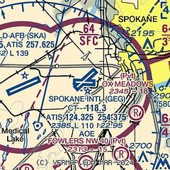
| Sectional chart |
|---|
|
CAUTION: Diagram may not be current
 Download PDF
of official airport diagram from the FAA
| Airport distance calculator |
|---|
|
|
| Sunrise and sunset |
|---|
|
Times for 31-May-2025
| | Local
(UTC-7) | | Zulu
(UTC) |
|---|
| Morning civil twilight | | 04:19 | | 11:19 |
| Sunrise | | 04:58 | | 11:58 |
| Sunset | | 20:38 | | 03:38 |
| Evening civil twilight | | 21:17 | | 04:17 |
|
| Current date and time |
|---|
| Zulu (UTC) | 31-May-2025 19:58:29 |
|---|
| Local (UTC-7) | 31-May-2025 12:58:29 |
|---|
|
| METAR |
|---|
| KGEG | 311953Z 21013G21KT 10SM FEW170 SCT210 28/06 A2988 RMK AO2 SLP102 T02780061
|
KSKA
5nm W | 311955Z 22013G17KT 10SM CLR 28/07 A2988 RMK AO2A SLP099 T02840070 $
|
KSFF
10nm NE | 311953Z 19011G19KT 10SM CLR 32/06 A2986 RMK AO2 SLP094 T03170061 $
|
|
| TAF |
|---|
| KGEG | 311720Z 3118/0118 20009G21KT P6SM SCT250 FM312200 24017G25KT P6SM SCT250 FM010000 25020G31KT P6SM BKN250 FM010700 24012KT P6SM BKN250 FM011200 25006KT P6SM BKN250 FM011500 32010KT P6SM BKN250
|
KSKA
5nm W | 311100Z 3111/0117 VRB06KT 9999 FEW200 QNH2990INS BECMG 3117/3118 19011KT 9999 SCT150 QNH2984INS BECMG 3119/3120 24015G25KT 9999 BKN120 QNH2981INS TEMPO 3123/0103 23020G30KT 510003 BECMG 0105/0106 28010G15KT 9999 SCT120 QNH2995INS BECMG 0107/0108 28009KT 9999 FEW150 QNH2995INS TX29/3122Z TN12/3112Z
|
KSFF
10nm NE | 311720Z 3118/0118 21006G18KT P6SM SCT250 FM312200 24014G22KT P6SM SCT250 FM010000 25013G27KT P6SM BKN250 FM010700 25005KT P6SM BKN250 FM011200 26005KT P6SM BKN250
|
|
| NOTAMs |
|---|
NOTAMs are issued by the DoD/FAA and will open in a separate window not controlled by AirNav.
|
|


