FAA INFORMATION EFFECTIVE 15 MAY 2025
Location
| FAA Identifier: | OGM |
| Lat/Long: | 46-50-43.6930N 089-22-01.5300W
46-50.728217N 089-22.025500W
46.8454703,-89.3670917
(estimated) |
| Elevation: | 665.2 ft. / 202.8 m (surveyed) |
| Variation: | 03W (2010) |
| From city: | 3 miles W of ONTONAGON, MI |
| Time zone: | UTC -4 (UTC -5 during Standard Time) |
| Zip code: | 49953 |
Airport Operations
| Airport use: | Open to the public |
| Activation date: | 08/1962 |
| Control tower: | no |
| ARTCC: | MINNEAPOLIS CENTER |
| FSS: | GREEN BAY FLIGHT SERVICE STATION |
| NOTAMs facility: | GRB (NOTAM-D service available) |
| Attendance: | UNATNDD |
| Wind indicator: | lighted |
| Segmented circle: | yes |
| Lights: | ACTVT REIL RWY 17 & 35; PAPI RWY 17 & 35; MIRL RWY 17/35 - CTAF. |
| Beacon: | white-green (lighted land airport)
Operates sunset to sunrise. |
Airport Communications
- APCH/DEP SVC PRVDD BY MINNEAPOLIS ARTCC (ZMP) ON FREQS 133.55/379.1 (HANCOCK RCAG).
Nearby radio navigation aids
| VOR radial/distance | | VOR name | | Freq | | Var |
|---|
| IWDr058/36.4 | | IRONWOOD VOR/DME | | 108.80 | | 01E |
Airport Services
| Fuel available: | 100LL
100LL:AVBL H24 SELF SVC WITH VISA OR MASTERCARD. |
| Parking: | tiedowns |
| Airframe service: | NONE |
| Powerplant service: | NONE |
| Bottled oxygen: | NONE |
| Bulk oxygen: | NONE |
Runway Information
Runway 17/35
| Dimensions: | 3503 x 75 ft. / 1068 x 23 m |
| Surface: | asphalt, in good condition |
| Weight bearing capacity: | |
| Runway edge lights: | medium intensity |
| RUNWAY 17 | | RUNWAY 35 |
| Latitude: | 46-51.004132N | | 46-50.452290N |
| Longitude: | 089-22.146425W | | 089-21.904605W |
| Elevation: | 639.5 ft. | | 665.2 ft. |
| Traffic pattern: | left | | left |
| Runway heading: | 166 magnetic, 163 true | | 346 magnetic, 343 true |
| Markings: | nonprecision, in good condition | | nonprecision, in good condition |
| Visual slope indicator: | 2-light PAPI on left (3.50 degrees glide path) | | 2-light PAPI on left (3.50 degrees glide path) |
| Runway end identifier lights: | yes | | yes |
| Touchdown point: | yes, no lights | | yes, no lights |
| Obstructions: | 52 ft. trees, 1162 ft. from runway, 317 ft. right of centerline, 18:1 slope to clear | | 20 ft. trees, 260 ft. from runway, 257 ft. left of centerline, 3:1 slope to clear
16 FT TREE, 150 FT DIST, 240 FT L. |
Airport Ownership and Management from official FAA records
| Ownership: | Publicly-owned |
| Owner: | ONTONAGON COUNTY
COURTHOUSE, 725 GREENLAND RD
ONTONAGON, MI 49953-1400
Phone 906-884-4255 |
| Manager: | LISA LINNA
35932 AIRPORT RD
ONTONAGON, MI 49953-9036
Phone 906-884-6214
CELL 906-390-0027. |
Additional Remarks
| - | DEER & BIRDS ON & INVOF ARPT. |
| - | FOR CD CTC MINNEAPOLIS ARTCC AT 651-463-5588. |
| - | ADZY ONLY WX AVBL - 4 CLICKS CTAF. |
Instrument Procedures
NOTE: All procedures below are presented as PDF files. If you need a reader for these files, you should download the free Adobe Reader.NOT FOR NAVIGATION. Please procure official charts for flight.
FAA instrument procedures published for use from 15 May 2025 at 0901Z to 13 June 2025 at 0900z.
IAPs - Instrument Approach Procedures |
|---|
| RNAV (GPS) RWY 35 | |
download (228KB) |
| NOTE: Special Take-Off Minimums/Departure Procedures apply | |
download (360KB) |
Other nearby airports with instrument procedures:
KIWD - Gogebic/Iron County Airport (37 nm SW)
KCMX - Houghton County Memorial Airport (41 nm NE)
KLNL - Kings Land O' Lakes Airport (42 nm S)
D25 - Manitowish Waters Airport (48 nm SW)
KEGV - Eagle River Union Airport (55 nm S)
|
|

Road maps at:
MapQuest
Bing
Google
| Aerial photo |
|---|
WARNING: Photo may not be current or correct
 Photo courtesy of Skypixs Aerials
Photo taken 17-Jul-2007
Photo courtesy of Skypixs Aerials
Photo taken 17-Jul-2007
Do you have a better or more recent aerial photo of Ontonagon County Airport/Schuster Field that you would like to share? If so, please send us your photo.
|
| Sectional chart |
|---|
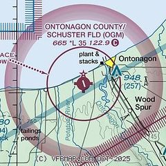
|
| Airport distance calculator |
|---|
|
|
| Sunrise and sunset |
|---|
|
Times for 24-May-2025
| | Local
(UTC-4) | | Zulu
(UTC) |
|---|
| Morning civil twilight | | 05:37 | | 09:37 |
| Sunrise | | 06:14 | | 10:14 |
| Sunset | | 21:35 | | 01:35 |
| Evening civil twilight | | 22:12 | | 02:12 |
|
| Current date and time |
|---|
| Zulu (UTC) | 25-May-2025 01:01:54 |
|---|
| Local (UTC-4) | 24-May-2025 21:01:54 |
|---|
|
| METAR |
|---|
KIWD
37nm SW | 250056Z AUTO 36003KT 10SM CLR 11/03 A3027 RMK AO2 SLP255 T01110028
|
KCMX
41nm NE | 250053Z AUTO 01005KT 10SM CLR 11/03 A3024 RMK AO2 SLP248 T01110033
|
KLNL
42nm S | 250055Z AUTO 01004KT 10SM CLR 13/02 A3024 RMK AO2 T01320022
|
KD25
48nm SW | 250055Z AUTO 33005KT 10SM CLR 12/01 A3024 RMK AO2 T01230010
|
|
| TAF |
|---|
KIWD
37nm SW | 241935Z 2420/2518 34007KT P6SM SCT040= TAF AMD KCMX 241937Z 2420/2518 29007KT P6SM SCT035 BKN050 FM250300 VRB04KT P6SM SCT070 FM251200 30007KT P6SM BKN045
|
KCMX
41nm NE | 241937Z 2420/2518 29007KT P6SM SCT035 BKN050 FM250300 VRB04KT P6SM SCT070 FM251200 30007KT P6SM BKN045
|
|
| NOTAMs |
|---|
NOTAMs are issued by the DoD/FAA and will open in a separate window not controlled by AirNav.
|
|


