FAA INFORMATION EFFECTIVE 17 APRIL 2025
Location
| FAA Identifier: | OJC |
| Lat/Long: | 38-50-51.3520N 094-44-15.3020W
38-50.855867N 094-44.255033W
38.8475978,-94.7375839
(estimated) |
| Elevation: | 1096.3 ft. / 334.2 m (surveyed) |
| Variation: | 04E (2000) |
| From city: | 4 miles SE of OLATHE, KS |
| Time zone: | UTC -5 (UTC -6 during Standard Time) |
| Zip code: | 66221 |
Airport Operations
| Airport use: | Open to the public |
| Activation date: | 10/1944 |
| Control tower: | yes |
| ARTCC: | KANSAS CITY CENTER |
| FSS: | COLUMBIA FLIGHT SERVICE STATION |
| NOTAMs facility: | OJC (NOTAM-D service available) |
| Attendance: | CONTINUOUS |
| Pattern altitude: | 2096.3 ft. MSL
TPA LOW PER ACFT 1000 FT AGL, HIGH PER ACFT 1500 FT AGL |
| Wind indicator: | lighted |
| Segmented circle: | no |
| Lights: | WHEN ATCT CLSD, ACTVT MALSR RWY 36; PAPI RWY 18; MIRL RWY 18-36; TWY LGTS; AND WIND CONE - CTAF. VASI RWY 36 OPR CONSLY. |
| Beacon: | white-green (lighted land airport)
Operates sunset to sunrise. |
Airport Communications
| CTAF: | 126.0 |
| UNICOM: | 122.95 |
| ATIS: | 119.35 |
| WX ASOS: | PHONE 913-780-6969 |
| EXECUTIVE GROUND: | 121.6 [0700-2100] |
| EXECUTIVE TOWER: | 126.0 225.4 [0700-2100] |
| KANSAS CITY APPROACH: | 118.9 |
| KANSAS CITY DEPARTURE: | 118.9 |
| BRAYMER STAR: | 120.95 |
| JHAWK STAR: | 120.95 |
| TYGER STAR: | 120.95 |
| WX ASOS at IXD (7 nm W): | 135.325 (913-780-6987) |
| WX ASOS at MKC (18 nm N): | 120.75 (816-329-2843) |
| WX ASOS at LXT (18 nm E): | 124.175 (816-347-9807) |
Nearby radio navigation aids
| VOR radial/distance | | VOR name | | Freq | | Var |
|---|
| MCIr175/26.3 | | KANSAS CITY VORTAC | | 113.25 | | 05E |
| ANXr235/32.1 | | NAPOLEON VORTAC | | 115.15 | | 07E |
| BUMr334/36.5 | | BUTLER VORTAC | | 115.90 | | 07E |
| NDB name | | Hdg/Dist | | Freq | | Var | | ID |
|---|
| HERBB | | 356/5.7 | | 420 | | 04E | | PK | .--. -.- |
Airport Services
| Fuel available: | 100LL JET-A |
| Parking: | hangars and tiedowns |
| Airframe service: | MAJOR |
| Powerplant service: | MAJOR |
| Bottled oxygen: | LOW |
| Bulk oxygen: | LOW |
Runway Information
Runway 18/36
| Dimensions: | 4097 x 75 ft. / 1249 x 23 m |
| Surface: | concrete, in excellent condition |
| Weight bearing capacity: | |
| Runway edge lights: | medium intensity |
| RUNWAY 18 | | RUNWAY 36 |
| Latitude: | 38-51.193312N | | 38-50.518428N |
| Longitude: | 094-44.254055W | | 094-44.256000W |
| Elevation: | 1096.3 ft. | | 1050.2 ft. |
| Traffic pattern: | left | | left |
| Runway heading: | 176 magnetic, 180 true | | 356 magnetic, 000 true |
| Declared distances: | TORA:4097 TODA:4097 ASDA:4097 LDA:4097 | | TORA:4097 TODA:4097 ASDA:4097 LDA:4097 |
| Markings: | nonprecision, in good condition | | nonprecision, in good condition |
| Visual slope indicator: | 4-light PAPI on right (3.00 degrees glide path) | | 2-box VASI on left (3.00 degrees glide path) |
| Approach lights: | | | MALSR: 1,400 foot medium intensity approach lighting system with runway alignment indicator lights |
| Runway end identifier lights: | no | | |
| Touchdown point: | yes, no lights | | yes, no lights |
| Instrument approach: | LOC/DME | | LOCALIZER |
| Obstructions: | none | | 34 ft. trees, 901 ft. from runway, 155 ft. left of centerline, 20:1 slope to clear |
Airport Ownership and Management from official FAA records
| Ownership: | Publicly-owned |
| Owner: | JOHNSON COUNTY
1 NEW CENTURY PARKWAY
OLATHE, KS 66031
Phone 913-715-6000 |
| Manager: | BRYAN JOHNSON
ONE NEW CENTURY PARKWAY
NEW CENTURY, KS 66031
Phone 913-715-6002 |
Additional Remarks
| A39-18/36 | PCR VALUE: 90/R/D/W/T |
| - | UPON TAKEOFF FOR RYS 18 & 36 MAINTAIN RY HEADING UNTIL PASSING 1,600 FT MSL. |
| - | BIRDS, WATERFOWL, WILDLIFE ON & INVOF ARPT. |
| - | TO CONFIRM SNOW REMOVAL AND WINTER CONDITIONS NOV-APR CALL 913-715-6005. |
| - | FOR CD WHEN ATCT IS CLSD CTC MCI APCH AT 816-329-2710. |
| - | IT IS ADVISED THAT ROTOCRAFT AVOID THE OVERFLIGHTS OF SURROUNDING NEIGHBORHOODS. |
Instrument Procedures
NOTE: All procedures below are presented as PDF files. If you need a reader for these files, you should download the free Adobe Reader.NOT FOR NAVIGATION. Please procure official charts for flight.
FAA instrument procedures published for use from 17 April 2025 at 0901Z to 15 May 2025 at 0900z.
STARs - Standard Terminal Arrivals |
|---|
| BRAYMER EIGHT **CHANGED** | |
2 pages:
[1] [2] (345KB) |
| JHAWK EIGHT **CHANGED** | |
download (221KB) |
| TYGER SEVEN **CHANGED** | |
2 pages:
[1] [2] (291KB) |
IAPs - Instrument Approach Procedures |
|---|
| RNAV (GPS) RWY 18 | |
download (213KB) |
| RNAV (GPS) RWY 36 | |
download (222KB) |
| LOC RWY 18 | |
download (236KB) |
| LOC RWY 36 | |
download (222KB) |
| NOTE: Special Alternate Minimums apply | |
download (147KB) |
| NOTE: Special Alternate Minimums apply | |
download (147KB) |
Departure Procedures |
|---|
| CHIEF NINE | |
download (155KB) |
| LAKES FIVE | |
download (209KB) |
| RACER EIGHT | |
download (197KB) |
| ROYAL TWO | |
download (180KB) |
| TIFTO EIGHT | |
download (134KB) |
| WILDCAT SIX | |
download (179KB) |
| NOTE: Special Take-Off Minimums/Departure Procedures apply | |
download (360KB) |
Other nearby airports with instrument procedures:
KIXD - New Century AirCenter Airport (7 nm W)
KMKC - Kansas City Downtown Airport-Wheeler Field (18 nm N)
KLXT - Kansas City/Lee's Summit Regional Airport (18 nm E)
K81 - Miami County Airport (20 nm SW)
KLRY - Lawrence Smith Memorial Airport (23 nm SE)
|
|

Road maps at:
MapQuest
Bing
Google
| Aerial photo |
|---|
WARNING: Photo may not be current or correct
 Photo by Matt Fuoco
Taken in the Spring of 2009
Photo by Matt Fuoco
Taken in the Spring of 2009
Do you have a better or more recent aerial photo of Johnson County Executive Airport that you would like to share? If so, please send us your photo.
|
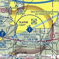
| Sectional chart |
|---|
|
 Download PDF
of official airport diagram from the FAA
| Airport distance calculator |
|---|
|
|
| Sunrise and sunset |
|---|
|
Times for 03-May-2025
| | Local
(UTC-5) | | Zulu
(UTC) |
|---|
| Morning civil twilight | | 05:51 | | 10:51 |
| Sunrise | | 06:20 | | 11:20 |
| Sunset | | 20:12 | | 01:12 |
| Evening civil twilight | | 20:41 | | 01:41 |
|
| Current date and time |
|---|
| Zulu (UTC) | 03-May-2025 23:28:24 |
|---|
| Local (UTC-5) | 03-May-2025 18:28:24 |
|---|
|
| METAR |
|---|
| KOJC | 032253Z 03013KT 10SM BKN065 18/03 A3001 RMK AO2 SLP160 T01780033
|
KIXD
7nm W | 032253Z 35013G16KT 10SM BKN060 19/05 A3001 RMK AO2 SLP161 T01890050
|
KGVW
8nm E | 032315Z AUTO 10SM CLR 25/10 A2992 RMK A01
|
KMKC
17nm N | 032254Z 03010G19KT 10SM FEW060 18/03 A3001 RMK AO2 SLP159 T01780033
|
KLXT
19nm NE | 032253Z AUTO 36010KT 10SM FEW050 SCT060 17/06 A3002 RMK AO2 SLP165 T01720056 $
|
|
| TAF |
|---|
KIXD
7nm W | 031720Z 0318/0418 35013G21KT P6SM FEW050 FM032300 02008KT P6SM FEW240 FM040800 05005KT P6SM FEW250
|
KMKC
17nm N | 031720Z 0318/0418 35011G20KT P6SM FEW040 FM032300 02008KT P6SM FEW200 FM040800 03004KT P6SM FEW240
|
|
| NOTAMs |
|---|
NOTAMs are issued by the DoD/FAA and will open in a separate window not controlled by AirNav.
|
|


