FAA INFORMATION EFFECTIVE 19 MARCH 2026
Location
| FAA Identifier: | SMF |
| Lat/Long: | 38-41-43.6000N 121-35-26.8000W
38-41.726667N 121-35.446667W
38.6954444,-121.5907778
(estimated) |
| Elevation: | 26.9 ft. / 8.2 m (surveyed) |
| Variation: | 13E (2020) |
| From city: | 10 miles NW of SACRAMENTO, CA |
| Time zone: | UTC -7 (UTC -8 during Standard Time) |
| Zip code: | 95837 |
Airport Operations
| Airport use: | Open to the public |
| Activation date: | 06/1962 |
| Control tower: | yes |
| ARTCC: | OAKLAND CENTER |
| FSS: | RANCHO MURIETA FLIGHT SERVICE STATION |
| NOTAMs facility: | SMF (NOTAM-D service available) |
| Attendance: | CONTINUOUS |
| Wind indicator: | lighted |
| Segmented circle: | no |
| Beacon: | white-green (lighted land airport)
Operates sunset to sunrise. |
| Fire and rescue: | ARFF index C |
| International operations: | customs landing rights airport |
Airport Communications
| UNICOM: | 122.95 |
| WX ASOS: | PHONE 916-649-3996 |
| CAPITOL GROUND: | 121.7 256.7 |
| CAPITOL TOWER: | 125.7 256.7 |
| NORCAL APPROACH: | 125.25 ;SW 125.4 ;W-NE 127.4 ;E-SE |
| NORCAL DEPARTURE: | 125.25 ;SW 125.4 ;W-NE 127.4 ;E-SE |
| CLEARANCE DELIVERY: | 121.1 256.7 |
| CLASS C: | 125.25 ;SW 125.4 ;W-NE 127.4 ;E-SE |
| CONCORD STAR: | 125.25 |
| D-ATIS: | 126.75 |
| FROGO DP: | 127.4 |
| FTHIL DP: | 127.4 |
| RVRCT DP: | 127.4 |
| SCTWN DP: | 127.4 |
| SLMMR STAR: | 120.45 |
| SUUTR STAR: | 124.8 |
| TUDOR STAR: | 120.45 |
| WX AWOS-3 at MCC (9 nm E): | 125.975 (916-641-1272) |
| WX ASOS at SAC (12 nm SE): | PHONE 916-421-0923 |
| WX AWOS-3 at EDU (13 nm SW): | 119.025 (530-754-6839) |
| WX AWOS-3P at DWA (14 nm SW): | 125.775 (530-750-2759) |
| WX AWOS-3PT at MHR (16 nm SE): | 118.325 (916-366-3371) |
| WX AWOS-3 at LHM (17 nm NE): | 124.25 (916-645-0698) |
- SAID IN USE. OPERATE TRANSPONDERS WITH ALTITUDE REPORTING MODE AND ADS-B (IF EQUIPPED) ENABLED ON ALL AIRPORT SURFACES.
Nearby radio navigation aids
| VOR radial/distance | | VOR name | | Freq | | Var |
|---|
| MCCr264/8.9 | | MC CLELLAN VOR/DME | | 109.20 | | 17E |
| SACr336/15.2 | | SACRAMENTO VORTAC | | 115.20 | | 17E |
| MYVr166/24.2 | | MARYSVILLE VOR/DME | | 110.80 | | 16E |
| ILAr120/30.4 | | WILLIAMS VORTAC | | 114.40 | | 18E |
| HNWr250/39.4 | | HANGTOWN VOR/DME | | 115.50 | | 17E |
Airport Services
| Fuel available: | 100LL JET-A |
| Parking: | tiedowns |
| Airframe service: | MINOR |
| Powerplant service: | MAJOR |
| Bottled oxygen: | NONE |
| Bulk oxygen: | NONE |
Runway Information
Runway 17L/35R
| Dimensions: | 8605 x 150 ft. / 2623 x 46 m |
| Surface: | concrete/grooved, in good condition |
| Weight bearing capacity: | | Single wheel: | 120.0 | | Double wheel: | 250.0 | | Double tandem: | 513.0 | | Dual double tandem: | 1033.0 |
|
| Runway edge lights: | high intensity |
| RUNWAY 17L | | RUNWAY 35R |
| Latitude: | 38-42.428288N | | 38-41.010843N |
| Longitude: | 121-34.803542W | | 121-34.827367W |
| Elevation: | 26.9 ft. | | 22.1 ft. |
| Traffic pattern: | left | | right |
| Runway heading: | 168 magnetic, 181 true | | 348 magnetic, 001 true |
| Declared distances: | TORA:8605 TODA:8605 ASDA:8605 LDA:8605 | | TORA:8605 TODA:8605 ASDA:8605 LDA:8605 |
| Markings: | precision, in good condition | | nonprecision, in good condition |
| Visual slope indicator: | 4-light PAPI on left (3.00 degrees glide path) | | 4-light PAPI on left (3.00 degrees glide path) |
| RVR equipment: | touchdown, rollout | | touchdown, rollout |
| Approach lights: | MALSR: 1,400 foot medium intensity approach lighting system with runway alignment indicator lights | | |
| Centerline lights: | yes | | yes |
| Touchdown point: | yes, lighted | | yes, no lights |
| Instrument approach: | ILS/DME | | |
Runway 17R/35L
| Dimensions: | 8598 x 150 ft. / 2621 x 46 m |
| Surface: | concrete/grooved, in good condition |
| Weight bearing capacity: | | Single wheel: | 120.0 | | Double wheel: | 250.0 | | Double tandem: | 550.0 | | Dual double tandem: | 1082.0 |
|
| Runway edge lights: | high intensity |
| RUNWAY 17R | | RUNWAY 35L |
| Latitude: | 38-42.440393N | | 38-41.023983N |
| Longitude: | 121-36.064935W | | 121-36.088458W |
| Elevation: | 24.8 ft. | | 22.5 ft. |
| Traffic pattern: | right | | left |
| Runway heading: | 168 magnetic, 181 true | | 348 magnetic, 001 true |
| Declared distances: | TORA:8598 TODA:8598 ASDA:8598 LDA:8598 | | TORA:8598 TODA:8598 ASDA:8598 LDA:8598 |
| Markings: | precision, in good condition | | precision, in good condition |
| Visual slope indicator: | 4-light PAPI on right (3.00 degrees glide path) | | 4-light PAPI on right (3.00 degrees glide path) |
| RVR equipment: | touchdown, midfield, rollout | | touchdown, midfield, rollout |
| Approach lights: | ALSF2: standard 2,400 foot high intensity approach lighting system with centerline sequenced flashers (category II or III)
ALSF2 OPRS AS SSALR TILL WX GOES BLW VFR. | | MALSR: 1,400 foot medium intensity approach lighting system with runway alignment indicator lights |
| Runway end identifier lights: | no | | no |
| Centerline lights: | yes | | yes |
| Touchdown point: | yes, lighted | | yes, no lights |
| Instrument approach: | ILS/DME | | ILS/DME |
Airport Ownership and Management from official FAA records
| Ownership: | Publicly-owned |
| Owner: | COUNTY OF SACRAMENTO
6900 AIRPORT BLVD
SACRAMENTO, CA 95837
Phone 916-929-5411 |
| Manager: | SHERI THOMPSON-DUARTE
6900 AIRPORT BLVD
SACRAMENTO, CA 95837
Phone 916-874-0519
AIRSIDE OPS MGR 916-874-0713; 24HR OPS 916-806-5309. |
Additional Remarks
| A39-17L/35R | PCR VALUE: 900/R/B/W/T |
| A39-17R/35L | PCR VALUE: 840/R/A/W/T |
| - | BIRDS ON AND IN VICINITY OF ARPT. |
| - | TWY RMK #2: THE MAXIMUM ALLOWABLE GROSS AIRCRAFT LOAD FOR TWYS G1, G2, AND THE GENERAL AVIATION PARKING APRON IS: 70,000 LBS FOR SINGLE GEAR AIRCRAFT; 170,000 LBS FOR DUAL GEAR AIRCRAFT; AND 250,000 LBS FOR DUAL TANDEM GEAR AIRCRAFT. |
| - | TWY RMK #2 CONT: AN ACFT CANNOT EXCEED THE AIRPLANE DESIGN GROUP III CRITERIA OR MUST HAVE A WHEEL BASE OF LESS THAN 60 FT. |
| - | MILITARY AIRCRAFT PARKING LIMITED. CONTACT ARPT OPNS IF PARKING IS REQUIRED (916) 806-5309. |
| - | PORTION OF TWY W 500 FT EAST OF TWY A TO 2100 FT EAST OF TWY A IS NOT VISIBLE FROM ATCT. |
| - | TWY Y4 RESTRICTED TO AIRCRAFT WITH A WINGSPAN OF LESS THAN 118 FT (GROUP III). |
| - | UNPAVED SFC NORTH OF TWY P AND EAST OF TWY A AND SOUTH OF CARGO 1 RAMP CLSD TO HEL. |
| - | ACFT MUST PUSH BACK TAIL TO THE NORTH FROM TRML GATES A1, A3 AND A5. |
| - | WEST RAMP SPOTS 63W, 65W, 66 & F1 RSTRD TO TOW IN AND TOW OUT ONLY FROM TXL B2. WHEN PUSHING BACK FOR DEP FROM WEST RAMP SPOTS 63W, 65W, 66 & F1 EACH ACFT IS TO PUSH BACK ONTO TXL B2 AND PULL FWD TO THE ENG START LINE PRIOR TO STARTING ENGS. ADG V ACFT PRKD ON SPOT 66 IS TO PUSH ONTO TWY A AFTER RCVG APVL FROM ATC. |
| - | TWY B1 RSTRD TO ACFT WITH A WINGSPAN OF LESS THAN 118 FT (GROUP III). |
| - | NOISE SENSITIVE AREAS W OF ARPT ON SAC RIVER. LCL TURN DISCOURAGED FOR JET ACFT. WHEN CONDUCTING IFR APCH IN VFR CONDITIONS EXECUTE MISSED APCH AT DEP END OF RYS. PLAN VFR PATTERNS TO E. USE MIN POWER SETTINGS. |
| - | ALL ACFT CTC ATC GND CTL PRIOR TO MOVEMENT ON RAMP. |
| - | CROP DUSTERS OPER INVOF ARPT AT OR BELOW 200 FT AGL. |
Instrument Procedures
NOTE: All procedures below are presented as PDF files. If you need a reader for these files, you should download the free Adobe Reader.NOT FOR NAVIGATION. Please procure official charts for flight.
FAA instrument procedures published for use from 19 March 2026 at 0901Z to 16 April 2026 at 0900Z.
STARs - Standard Terminal Arrivals |
|---|
| CONCORD TWO | |
download (108KB) |
| SLMMR FIVE (RNAV) | |
download (233KB) |
| SUUTR FOUR (RNAV) | |
download (258KB) |
| TUDOR TWO | |
2 pages:
[1] [2] (256KB) |
IAPs - Instrument Approach Procedures |
|---|
| ILS OR LOC RWY 17L | |
download (290KB) |
| ILS OR LOC RWY 17R | |
download (297KB) |
| ILS OR LOC RWY 35L | |
download (278KB) |
| ILS RWY 17R (SA CAT I) | |
download (253KB) |
| ILS RWY 17R (CAT II - III) | |
download (249KB) |
| ILS RWY 17L (SA CAT II) | |
download (235KB) |
| RNAV (RNP) Z RWY 17L | |
download (232KB) |
| RNAV (RNP) Z RWY 17R | |
download (220KB) |
| RNAV (RNP) Z RWY 35L | |
download (224KB) |
| RNAV (RNP) Z RWY 35R | |
download (206KB) |
| RNAV (GPS) Y RWY 17L | |
download (241KB) |
| RNAV (GPS) Y RWY 17R | |
download (235KB) |
| RNAV (GPS) Y RWY 35L | |
download (232KB) |
| RNAV (GPS) Y RWY 35R | |
download (205KB) |
| NOTE: Special Alternate Minimums apply | |
download (148KB) |
Departure Procedures |
|---|
| FROGO ONE | |
download (171KB) |
| FTHIL THREE (RNAV) | |
download (140KB) |
| RVRCT FOUR (RNAV) | |
download (170KB) |
| SCTWN FOUR (RNAV) | |
download (173KB) |
| NOTE: Special Take-Off Minimums/Departure Procedures apply | |
download (356KB) |
Other nearby airports with instrument procedures:
KMCC - Mc Clellan Airfield (9 nm E)
KSAC - Sacramento Executive Airport (12 nm SE)
O41 - Watts-Woodland Airport (13 nm W)
KEDU - University Airport (13 nm SW)
KDWA - Yolo County Airport (14 nm SW)
KMHR - Sacramento Mather Airport (16 nm SE)
KLHM - Lincoln Regional Airport/Karl Harder Field (17 nm NE)
|
|

Road maps at:
MapQuest
Bing
Google
| Aerial photo |
|---|
WARNING: Photo may not be current or correct
 Photo by Trace Lewis
Photo taken 29-Jun-2012
looking north from about 4,500'.
Photo by Trace Lewis
Photo taken 29-Jun-2012
looking north from about 4,500'.
Do you have a better or more recent aerial photo of Sacramento International Airport that you would like to share? If so, please send us your photo.
|
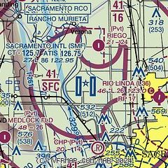
| Sectional chart |
|---|
|
 Download PDF
of official airport diagram from the FAA
| Airport distance calculator |
|---|
|
|
| Sunrise and sunset |
|---|
|
Times for 05-Apr-2026
| | Local
(UTC-7) | | Zulu
(UTC) |
|---|
| Morning civil twilight | | 06:19 | | 13:19 |
| Sunrise | | 06:46 | | 13:46 |
| Sunset | | 19:32 | | 02:32 |
| Evening civil twilight | | 19:59 | | 02:59 |
|
| Current date and time |
|---|
| Zulu (UTC) | 06-Apr-2026 03:05:13 |
|---|
| Local (UTC-7) | 05-Apr-2026 20:05:13 |
|---|
|
| METAR |
|---|
| KSMF | 060253Z 00000KT 10SM FEW150 BKN210 22/06 A2994 RMK AO2 SLP137 T02220061 56006
|
KMCC
9nm E | 060250Z AUTO 33004KT 10SM CLR 24/06 A2994 RMK AO2
|
KSAC
12nm S | 060253Z 00000KT 10SM CLR 22/06 A2994 RMK AO2 SLP137 T02220061 56005
|
KEDU
13nm SW | 060255Z AUTO 00000KT 10SM 21/08 A2995 RMK AO1
|
KDWA
14nm SW | 060255Z AUTO 00000KT 10SM CLR 22/08 A2996 RMK AO2
|
KLHM
17nm NE | 060255Z AUTO 00000KT 10SM CLR 21/08 A2994 RMK AO1
|
KMHR
17nm SE | 060255Z AUTO 34004KT 10SM CLR 25/05 A2993 RMK AO2
|
|
| TAF |
|---|
| KSMF | 051720Z 0518/0618 34005KT P6SM SCT250 FM060400 VRB03KT P6SM FEW250
|
KMCC
9nm E | 051720Z 0518/0618 35004KT P6SM FEW250 FM060000 VRB03KT P6SM FEW250
|
KSAC
12nm S | 051720Z 0518/0618 35005KT P6SM SCT250 FM060400 VRB04KT P6SM FEW250
|
KMHR
17nm SE | 051720Z 0518/0618 34004KT P6SM FEW250 FM060400 VRB03KT P6SM FEW250
|
|
| NOTAMs |
|---|
NOTAMs are issued by the DoD/FAA and will open in a separate window not controlled by AirNav.
|
|


