FAA INFORMATION EFFECTIVE 15 MAY 2025
Location
| FAA Identifier: | WLD |
| Lat/Long: | 37-10-07.0000N 097-02-15.1000W
37-10.116667N 097-02.251667W
37.1686111,-97.0375278
(estimated) |
| Elevation: | 1160.3 ft. / 353.7 m (surveyed) |
| Variation: | 06E (2000) |
| From city: | 5 miles SW of central business district of the associated city |
| Time zone: | UTC -5 (UTC -6 during Standard Time) |
| Zip code: | 67156 |
Airport Operations
| Airport use: | Open to the public |
| Activation date: | 01/1943 |
| Control tower: | no |
| ARTCC: | KANSAS CITY CENTER |
| FSS: | WICHITA FLIGHT SERVICE STATION |
| NOTAMs facility: | WLD (NOTAM-D service available) |
| Attendance: | MON-FRI 0800-1630 |
| Wind indicator: | lighted |
| Segmented circle: | no |
| Lights: | ACTVT MIRL RY 13/31 & HIRL RY 17/35; PAPI AND REIL RYS 17 & 35 - CTAF. |
| Beacon: | white-green (lighted land airport)
Operates sunset to sunrise. |
Airport Communications
| CTAF/UNICOM: | 122.8 |
| WX ASOS: | 118.025 (620-221-9121) |
| WX AWOS-3P at EGT (19 nm NW): | 118.875 (620-359-2156) |
- APCH/DEP CTL SVC PRVDD BY KANSAS CITY ARTCC (ZKC) ON FREQS 127.8/319.1 (PONCA CITY RCAG).
Nearby radio navigation aids
| VOR radial/distance | | VOR name | | Freq | | Var |
|---|
| PERr007/26.0 | | PIONEER VORTAC | | 113.20 | | 06E |
Airport Services
| Fuel available: | 100LL JET-A
100LL:FUEL 24 HR SELF SERV.. |
| Parking: | hangars and tiedowns |
| Bottled oxygen: | NONE |
Runway Information
Runway 17/35
| Dimensions: | 5506 x 100 ft. / 1678 x 30 m |
| Surface: | asphalt, in good condition |
| Weight bearing capacity: | | PCN 16 /F/D/X/T | | Single wheel: | 45.0 | | Double wheel: | 60.0 |
|
| Runway edge lights: | high intensity |
| RUNWAY 17 | | RUNWAY 35 |
| Latitude: | 37-10.636402N | | 37-09.729180N |
| Longitude: | 097-02.166543W | | 097-02.166388W |
| Elevation: | 1158.1 ft. | | 1149.5 ft. |
| Traffic pattern: | left | | left |
| Runway heading: | 174 magnetic, 180 true | | 354 magnetic, 360 true |
| Markings: | nonprecision, in good condition | | nonprecision, in good condition |
| Visual slope indicator: | 4-light PAPI on left (3.00 degrees glide path) | | 4-light PAPI on left (3.00 degrees glide path) |
| Runway end identifier lights: | yes | | yes |
| Touchdown point: | yes, no lights | | yes, no lights |
| Instrument approach: | | | ILS |
| Obstructions: | none | | 56 ft. trees, 1678 ft. from runway, 370 ft. left of centerline, 26:1 slope to clear |
Runway 13/31
| Dimensions: | 3137 x 75 ft. / 956 x 23 m |
| Surface: | asphalt, in good condition |
| Weight bearing capacity: | | Single wheel: | 28.0 | | Double wheel: | 48.0 |
|
| Runway edge lights: | medium intensity |
| RUNWAY 13 | | RUNWAY 31 |
| Latitude: | 37-10.199835N | | 37-09.803828N |
| Longitude: | 097-02.608208W | | 097-02.193100W |
| Elevation: | 1160.3 ft. | | 1151.6 ft. |
| Traffic pattern: | left | | left |
| Runway heading: | 134 magnetic, 140 true | | 314 magnetic, 320 true |
| Markings: | basic, in good condition | | basic, in good condition |
| Touchdown point: | yes, no lights | | yes, no lights |
Airport Ownership and Management from official FAA records
| Ownership: | Publicly-owned |
| Owner: | CITIES OF WINFIELD & ARKANSAS
PO BOX 747
WINFIELD, KS 67156
Phone 620-221-9280 |
| Manager: | SHAWN MCGREW
22193 TUPPER ST
WINFIELD, KS 67156
Phone 620-221-9280
AFTER HOURS PHONE 620-221-9280 . |
Additional Remarks
| - | PILOT LOUNGE KEY CODE 1228 |
Instrument Procedures
NOTE: All procedures below are presented as PDF files. If you need a reader for these files, you should download the free Adobe Reader.NOT FOR NAVIGATION. Please procure official charts for flight.
FAA instrument procedures published for use from 15 May 2025 at 0901Z to 13 June 2025 at 0900z.
IAPs - Instrument Approach Procedures |
|---|
| RNAV (GPS) RWY 17 | |
download (249KB) |
| RNAV (GPS) RWY 35 | |
download (257KB) |
| NOTE: Special Alternate Minimums apply | |
download (149KB) |
| NOTE: Special Take-Off Minimums/Departure Procedures apply | |
download (360KB) |
Other nearby airports with instrument procedures:
KEGT - Wellington Municipal Airport (19 nm NW)
K50 - Cook Airfield (25 nm N)
KPNC - Ponca City Regional Airport (26 nm S)
KIAB - Mc Connell Air Force Base (29 nm N)
KBKN - Blackwell-Tonkawa Municipal Airport (29 nm SW)
|
|

Road maps at:
MapQuest
Bing
Google
| Aerial photo |
|---|
WARNING: Photo may not be current or correct

Do you have a better or more recent aerial photo of Strother Field Airport that you would like to share? If so, please send us your photo.
|
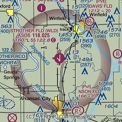
| Sectional chart |
|---|
|
| Airport distance calculator |
|---|
|
|
| Sunrise and sunset |
|---|
|
Times for 28-May-2025
| | Local
(UTC-5) | | Zulu
(UTC) |
|---|
| Morning civil twilight | | 05:42 | | 10:42 |
| Sunrise | | 06:12 | | 11:12 |
| Sunset | | 20:39 | | 01:39 |
| Evening civil twilight | | 21:09 | | 02:09 |
|
| Current date and time |
|---|
| Zulu (UTC) | 29-May-2025 00:37:09 |
|---|
| Local (UTC-5) | 28-May-2025 19:37:09 |
|---|
|
| METAR |
|---|
| KWLD | 282354Z AUTO 11005KT 10SM OVC110 19/14 A3000 RMK AO2 RAE2257B18E40 SLP153 P0000 60000 T01890144 10228 20189 58027 $
|
KEGT
19nm NW | 290015Z AUTO 10005KT 10SM -RA BKN042 BKN065 OVC110 18/15 A3002 RMK AO2 T01770152
|
|
| TAF |
|---|
KPNC
26nm S | 281726Z 2818/2918 06008KT P6SM BKN025 FM282100 13009KT P6SM BKN040 BKN100 TEMPO 2907/2911 4SM TSRA BKN025CB FM291100 34012G20KT P6SM BKN015
|
KIAB
29nm N | 281800Z 2818/2924 14006KT 9999 SCT025 BKN090 QNH3004INS BECMG 2820/2821 15010G17KT 9000 -SHRA VCTS BKN030CB OVC090 QNH3002INS BECMG 2823/2824 12009KT 9999 VCSH SCT030 BKN100 QNH3002INS BECMG 2902/2903 10012G18KT 8000 -SHRA VCTS BKN012 OVC020CB QNH3004INS TEMPO 2905/2911 VRB25G40KT 4800 TSRA BKN007 OVC012CB BECMG 2911/2912 35009KT 9999 VCSH BKN007 OVC015 QNH3011INS BECMG 2914/2915 35015G25KT 9999 BKN015 OVC120 540154 QNH3014INS BECMG 2917/2918 36012G22KT 9999 BKN025 BKN120 540254 QNH3015INS BECMG
|
|
| NOTAMs |
|---|
NOTAMs are issued by the DoD/FAA and will open in a separate window not controlled by AirNav.
|
|


