FAA INFORMATION EFFECTIVE 14 MAY 2026
Location
| FAA Identifier: | RYY |
| Lat/Long: | 34-00-47.4000N 084-35-49.3000W
34-00.790000N 084-35.821667W
34.0131667,-84.5970278
(estimated) |
| Elevation: | 1040.4 ft. / 317.1 m (surveyed) |
| Variation: | 04W (2005) |
| From city: | 21 miles NW of ATLANTA, GA |
| Time zone: | UTC -4 (UTC -5 during Standard Time) |
| Zip code: | 30144 |
Airport Operations
| Airport use: | Open to the public |
| Activation date: | 12/1942 |
| Control tower: | yes |
| ARTCC: | ATLANTA CENTER |
| FSS: | MACON FLIGHT SERVICE STATION |
| NOTAMs facility: | RYY (NOTAM-D service available) |
| Attendance: | 0600-0000 |
| Wind indicator: | lighted |
| Segmented circle: | yes |
| Lights: | WHEN ATCT CLSD, ACTVT MALSF RWY 27; HIRL RWY 09/27 - CTAF. |
| Beacon: | white-green (lighted land airport)
Operates sunset to sunrise. |
| Landing fee: | yes, LDG FEE FOR TSNT ACFT OVER 6000 LBS AND ALL TSNT ACFT BTWN 2100L-0600L. |
| Airline operations: | INDEX B AIRCRAFT RESCUE AND FIRE FIGHTING EQUIPMENT AVAILABLE UPON REQUEST. 24 HOUR PRIOR PERMISSION REQUIRED. CONTACT AIRPORT MANAGER 770-528-1615. |
| International operations: | customs landing rights airport |
Airport Communications
| CTAF: | 125.9 |
| UNICOM: | 122.7 |
| ATIS: | 128.125 |
| WX AWOS-3PT: | PHONE 770-425-3406 |
| MC COLLUM GROUND: | 119.0 [0700-2300] |
| MC COLLUM TOWER: | 125.9 [0700-2300] |
| ATLANTA APPROACH: | 121.0 |
| ATLANTA DEPARTURE: | 121.0 |
| CLEARANCE DELIVERY: | 119.0 121.0 ;WHEN TWR CLSD |
| BOKRT STAR: | 119.8 |
| WRGNZ STAR: | 128.575 |
| WX AWOS-3PT at VPC (14 nm NW): | 120.525 (770-607-7782) |
| WX ASOS at FTY (14 nm S): | PHONE 404-696-5660 |
| WX ASOS at PDK (17 nm SE): | 128.4 (770-457-1691) |
| WX AWOS-3 at PUJ (18 nm W): | 126.225 (770-445-3870) |
| WX AWOS-3PT at CNI (20 nm NE): | 119.825 (678-454-2065) |
Nearby radio navigation aids
| VOR radial/distance | | VOR name | | Freq | | Var |
|---|
| RMGr108/27.5 | | ROME VORTAC | | 115.40 | | 01E |
| NDB name | | Hdg/Dist | | Freq | | Var | | ID |
|---|
| CARROLLTON | | 049/37.8 | | 278 | | 04W | | GPQ | --. .--. --.- |
Airport Services
| Fuel available: | 100LL JET-A+ |
| Parking: | hangars and tiedowns |
| Airframe service: | MAJOR |
| Powerplant service: | MAJOR |
| Bottled oxygen: | NONE |
| Bulk oxygen: | HIGH/LOW |
Runway Information
Runway 9/27
| Dimensions: | 6295 x 100 ft. / 1919 x 30 m |
| Surface: | concrete/grooved, in good condition |
| Weight bearing capacity: | |
| Runway edge lights: | high intensity |
| RUNWAY 9 | | RUNWAY 27 |
| Latitude: | 34-00.778198N | | 34-00.800712N |
| Longitude: | 084-36.444735W | | 084-35.198760W |
| Elevation: | 1040.4 ft. | | 998.2 ft. |
| Traffic pattern: | right | | left |
| Runway heading: | 093 magnetic, 089 true | | 273 magnetic, 269 true |
| Displaced threshold: | 1062 ft. | | no |
| Declared distances: | TORA:6311 TODA:6311 ASDA:6311 LDA:5233 | | TORA:6311 TODA:6311 ASDA:5374 LDA:5374 |
| Markings: | nonprecision, in good condition | | precision, in good condition |
| Visual slope indicator: | 4-light PAPI on left (4.00 degrees glide path) | | 4-light PAPI on left (3.00 degrees glide path) |
| Approach lights: | | | MALSF: 1,400 foot medium intensity approach lighting system with sequenced flashers |
| Runway end identifier lights: | | | no |
| Touchdown point: | yes, no lights | | yes, no lights |
| Instrument approach: | | | ILS/DME |
| Obstructions: | 26 ft. road, 1 ft. from runway, 381 ft. right of centerline
ROAD 0-200 FROM RUNWAY END, 380' RIGHT AND 180' LEFT. | | 37 ft. trees, 722 ft. from runway, 314 ft. right of centerline, 14:1 slope to clear |
Airport Ownership and Management from official FAA records
| Ownership: | Publicly-owned |
| Owner: | COBB COUNTY
100 CHEROKEE STREET
MARIETTA, GA 30060
Phone 770-528-1615 |
| Manager: | STEVEN SPENCER
1723 MCCOLLUM PKWY BLDG 100
KENNESAW, GA 30144
Phone 770-528-8220 |
Additional Remarks
| - | BLASTING SR-SS MON-FRI 2000 FT AER 27. |
| - | TWY B CLSD FM TWY B5 TO B6 TO ACFT WITH WINGSPANS OF 79 FT OR GTR. |
| - | TURBINE/JET AIRCRAFT OPERATORS ARE REQUESTED TO USE NBAA NOISE ABATEMENT PROGRAM PROCEDURES OR COMPARABLE PROCEDURES OF AIRCRAFT MANUFACTURER. |
| - | INT'L OPS ARPT OF ENTRY - USER FEE AIRPORT |
| - | ARPT MOWING IN PROGRESS SPRING THRU AUTUMN. |
| - | COYOTES ON & INVOF ARPT. |
| - | RY 9 IS CALM WIND RY IN VFR CONDS. |
| - | NORTH APRON AT TWY A-1 CONNECTOR IS RESTRICTED TO GROUP 1 AFCT ONLY. |
Instrument Procedures
NOTE: All procedures below are presented as PDF files. If you need a reader for these files, you should download the free Adobe Reader.NOT FOR NAVIGATION. Please procure official charts for flight.
FAA instrument procedures published for use from 14 May 2026 at 0901Z to 11 June 2026 at 0900Z.
STARs - Standard Terminal Arrivals |
|---|
| BOKRT THREE (RNAV) | |
download (186KB) |
| BUKHD THREE (RNAV) | |
download (190KB) |
| DEHAN THREE (RNAV) | |
2 pages:
[1] [2] (326KB) |
| SWTEE TWO (RNAV) | |
download (142KB) |
| WRGNZ THREE (RNAV) | |
download (245KB) |
IAPs - Instrument Approach Procedures |
|---|
| ILS OR LOC RWY 27 **CHANGED** | |
download (247KB) |
| RNAV (GPS) RWY 09 **CHANGED** | |
download (220KB) |
| RNAV (GPS) RWY 27 **CHANGED** | |
download (220KB) |
| VOR/DME RWY 09 **CHANGED** | |
download (220KB) |
| NOTE: Special Alternate Minimums apply | |
download (157KB) |
| NOTE: Special Take-Off Minimums/Departure Procedures apply | |
download (479KB) |
Other nearby airports with instrument procedures:
KMGE - Dobbins ARB Airport (7 nm SE)
KVPC - Cartersville Airport (14 nm NW)
KFTY - Fulton County Executive Airport/Charlie Brown Field (14 nm S)
KPDK - Dekalb-Peachtree Airport (17 nm SE)
KPUJ - Paulding Northwest Atlanta Airport (18 nm W)
KCNI - Cherokee County Regional Airport (20 nm NE)
|
|

Road maps at:
MapQuest
Bing
Google
| Aerial photo |
|---|
WARNING: Photo may not be current or correct
 Photo taken 01-Apr-2012
looking northwest.
Photo taken 01-Apr-2012
looking northwest.
Do you have a better or more recent aerial photo of Cobb County International Airport-McCollum Field that you would like to share? If so, please send us your photo.
|
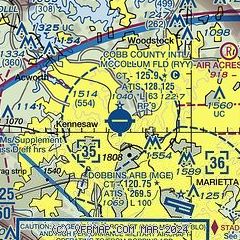
| Sectional chart |
|---|
|
 Download PDF
of official airport diagram from the FAA
| Airport distance calculator |
|---|
|
|
| Sunrise and sunset |
|---|
|
Times for 09-Jun-2026
| | Local
(UTC-4) | | Zulu
(UTC) |
|---|
| Morning civil twilight | | 05:59 | | 09:59 |
| Sunrise | | 06:28 | | 10:28 |
| Sunset | | 20:48 | | 00:48 |
| Evening civil twilight | | 21:17 | | 01:17 |
|
| Current date and time |
|---|
| Zulu (UTC) | 09-Jun-2026 23:01:34 |
|---|
| Local (UTC-4) | 09-Jun-2026 19:01:34 |
|---|
|
| METAR |
|---|
| KRYY | 092250Z 09004KT 10SM FEW023 28/23 A3015 RMK AO2 SLP196 T02780228 $
|
KMGE
7nm SE | 092155Z 09004KT 10SM FEW050 FEW120 SCT200 28/23 A3012 RMK AO2A SLP189 T02820226 $
|
KFTY
14nm S | 092253Z 17008KT 10SM CLR 28/22 A3012 RMK AO2 SLP190 T02830217
|
KVPC
14nm NW | 092255Z AUTO 13007KT 10SM CLR 31/23 A3013 RMK AO2
|
KPDK
17nm SE | 092253Z 17004KT 9SM CLR 27/22 A3013 RMK AO2 SLP186 T02720222
|
KPUJ
18nm W | 092255Z AUTO VRB05KT 10SM FEW065 27/23 A3015 RMK AO2
|
KCNI
20nm NE | 092255Z AUTO 13004KT 10SM SCT027 SCT036 BKN047 26/22 A3016 RMK AO2 T02640217
|
|
| TAF |
|---|
| KRYY | 091723Z 0918/1018 16004KT P6SM VCSH BKN035 BKN100 TEMPO 0918/0922 -TSRA BKN025CB FM100000 VRB03KT P6SM SCT035 BKN120 FM100600 00000KT 6SM BR SCT010 SCT100 FM101400 24004KT P6SM SCT035
|
KMGE
7nm SE | 092115Z 0921/1103 12007KT 9999 VCTS FEW016 SCT050CB BKN120 BKN200 QNH3010INS TEMPO 0921/0924 VRB12G20KT 8000 -TSRA BR OVC025CB BECMG 0923/0924 17005KT 9999 NSW SCT050 SCT150 BKN250 QNH3009INS BECMG 1008/1009 VRB05KT 8000 BR OVC010 QNH3007INS BECMG 1013/1014 18005KT 9999 NSW SCT010 BKN025 OVC050 QNH3008INS BECMG 1023/1024 VRB05KT 9999 FEW050 SCT250 QNH3000INS TX31/1019Z TN21/1012Z LAST NO AMDS AFT 1003 NEXT 1011
|
KFTY
14nm S | 091723Z 0918/1018 14005KT P6SM VCSH BKN035 BKN100 PROB30 0918/0924 -TSRA BKN025CB FM100000 00000KT P6SM SCT040 BKN100 FM100900 00000KT 6SM BR SCT009 BKN040 FM101500 VRB03KT P6SM SCT035 BKN100
|
KPDK
17nm SE | 091723Z 0918/1018 17003KT P6SM VCSH SCT035 BKN100 PROB30 0918/0924 -TSRA BKN025CB FM100000 00000KT P6SM SCT030 BKN100 FM100900 00000KT 6SM BR SCT006 BKN035 FM101500 25004KT P6SM SCT035 SCT060
|
|
| NOTAMs |
|---|
NOTAMs are issued by the DoD/FAA and will open in a separate window not controlled by AirNav.
|
|


