FAA INFORMATION EFFECTIVE 09 JULY 2026
Location
| FAA Identifier: | SVH |
| Lat/Long: | 35-45-53.9880N 080-57-14.0400W
35-45.899800N 080-57.234000W
35.7649967,-80.9539000
(estimated) |
| Elevation: | 967.8 ft. / 295.0 m (surveyed) |
| Variation: | 08W (2015) |
| From city: | 3 miles SW of STATESVILLE, NC |
| Time zone: | UTC -4 (UTC -5 during Standard Time) |
| Zip code: | 28677 |
Airport Operations
| Airport use: | Open to the public |
| Activation date: | 03/1940 |
| Control tower: | no |
| ARTCC: | ATLANTA CENTER |
| FSS: | RALEIGH FLIGHT SERVICE STATION |
| NOTAMs facility: | SVH (NOTAM-D service available) |
| Attendance: | MON-FRI 0700-2000, ALL SAT-SUN 0800-2000
FOR AFT HRS SVC CALL (704) 437-6617 OR (704) 880-6897. |
| Wind indicator: | lighted |
| Segmented circle: | yes |
| Lights: | ACTVT MALSR RWY 28; REIL RWY 10; PAPI RWY 10 & 28; HIRL RWY 10/28 - CTAF. |
| Beacon: | white-green (lighted land airport)
Operates sunset to sunrise. |
Airport Communications
| CTAF/UNICOM: | 123.075 |
| WX AWOS-3: | 119.225 (704-873-1978) |
| KABEE STAR: | 126.15 |
| WX AWOS-3 at IPJ (20 nm SW): | 119.675 (704-735-6954) |
- APCH/DEP SVC PRVDD BY ATLANTA ARTCC (HICKORY RCAG) ON FREQS 125.15/263.0.
Nearby radio navigation aids
| VOR radial/distance | | VOR name | | Freq | | Var |
|---|
| BZMr120/15.3 | | BARRETTS MOUNTAIN VOR/DME | | 113.75 | | 06W |
| CLTr005/34.5 | | CHARLOTTE VOR/DME | | 115.00 | | 05W |
| NDB name | | Hdg/Dist | | Freq | | Var | | ID |
|---|
| FIDDLERS | | 092/35.1 | | 391 | | 07W | | FIQ | ..-. .. --.- |
| STONIA | | 022/35.8 | | 260 | | 06W | | GHJ | --. .... .--- |
Airport Services
| Fuel available: | 100LL JET-A JET-A1+ |
| Parking: | hangars and tiedowns |
| Airframe service: | MAJOR |
| Powerplant service: | MAJOR |
| Bottled oxygen: | HIGH |
| Bulk oxygen: | HIGH |
Runway Information
Runway 10/28
| Dimensions: | 7003 x 100 ft. / 2135 x 30 m |
| Surface: | asphalt/grooved, in excellent condition |
| Weight bearing capacity: | | Single wheel: | 30.0 | | Double wheel: | 100.0 |
|
| Runway edge lights: | high intensity |
| RUNWAY 10 | | RUNWAY 28 |
| Latitude: | 35-45.968470N | | 35-45.831052N |
| Longitude: | 080-57.937008W | | 080-56.531015W |
| Elevation: | 958.6 ft. | | 956.9 ft. |
| Traffic pattern: | left | | left |
| Runway heading: | 105 magnetic, 097 true | | 285 magnetic, 277 true |
| Displaced threshold: | no | | 550 ft. |
| Declared distances: | TORA:7003 TODA:7003 ASDA:6453 LDA:6453 | | TORA:7003 TODA:8003 ASDA:7003 LDA:6453 |
| Markings: | nonprecision, in good condition | | precision, in good condition |
| Visual slope indicator: | 4-light PAPI on left (3.00 degrees glide path) | | 4-light PAPI on left (3.00 degrees glide path) |
| Approach lights: | | | MALSR: 1,400 foot medium intensity approach lighting system with runway alignment indicator lights |
| Runway end identifier lights: | yes | | |
| Touchdown point: | yes, no lights | | yes, no lights |
| Instrument approach: | | | ILS/DME |
| Obstructions: | 49 ft. trees, 671 ft. from runway, 468 ft. left of centerline, 9:1 slope to clear | | 46 ft. trees, 1170 ft. from runway, 560 ft. left of centerline, 21:1 slope to clear
APCH SLP 34:1 AT DSPLCD THR DUE TO +43 FT TREES 1696 FT FM DSPLCD THR AND 617 FT LEFT OF CNTRLN. |
Airport Ownership and Management from official FAA records
| Ownership: | Publicly-owned |
| Owner: | CITY OF STATESVILLE
PO BOX 1111
STATESVILLE, NC 28687
Phone 704-873-1111 |
| Manager: | JOHN M. FERGUSON
238 AIRPORT ROAD
STATESVILLE, NC 28677
Phone 704-873-1111 |
Additional Remarks
| - | RWY 28 HAS 100 FT DROP-OFF 250 FT RIGHT OF CNTRLN. |
| - | NO LINE OF SIGHT BTN RWYS. |
| - | FOR AFTER HRS NAVL/LGT FAILURE CALL 704-880-6897. |
| - | FOR CD CTC ATLANTA ARTCC AT 770-210-7692. |
| - | TWY A AT BOTH RWY ENDS HAS 80 FT TO 100 FT DROP-OFF 50 FT FM TWY CNTRLN. |
Instrument Procedures
NOTE: All procedures below are presented as PDF files. If you need a reader for these files, you should download the free Adobe Reader.NOT FOR NAVIGATION. Please procure official charts for flight.
FAA instrument procedures published for use from 09 July 2026 at 0901Z to 06 August 2026 at 0900Z.
STARs - Standard Terminal Arrivals |
|---|
| KABEE THREE (RNAV) **NEW** | |
download (151KB) |
IAPs - Instrument Approach Procedures |
|---|
| ILS OR LOC RWY 28 | |
download (222KB) |
| RNAV (GPS) RWY 10 | |
download (199KB) |
| RNAV (GPS) RWY 28 | |
download (275KB) |
| NOTE: Special Alternate Minimums apply | |
download (168KB) |
| NOTE: Special Take-Off Minimums/Departure Procedures apply | |
download (382KB) |
Other nearby airports with instrument procedures:
14A - Lake Norman Airpark (9 nm S)
KIPJ - Lincoln County Regional Airport (20 nm SW)
KHKY - Hickory Regional Airport (21 nm W)
KRUQ - Mid-Carolina Regional Airport (22 nm E)
KJQF - Concord-Padgett Regional Airport (26 nm SE)
|
|

Road maps at:
MapQuest
Bing
Google
| Aerial photo |
|---|
WARNING: Photo may not be current or correct
 Photo by Brian Tesar
Photo taken 04-Jul-2019
looking southwest.
Photo by Brian Tesar
Photo taken 04-Jul-2019
looking southwest.
Do you have a better or more recent aerial photo of Statesville Regional Airport that you would like to share? If so, please send us your photo.
|
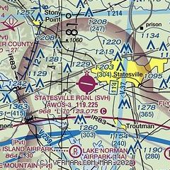
| Sectional chart |
|---|
|
| Airport distance calculator |
|---|
|
|
| Sunrise and sunset |
|---|
|
Times for 29-Jul-2026
| | Local
(UTC-4) | | Zulu
(UTC) |
|---|
| Morning civil twilight | | 06:02 | | 10:02 |
| Sunrise | | 06:30 | | 10:30 |
| Sunset | | 20:30 | | 00:30 |
| Evening civil twilight | | 20:59 | | 00:59 |
|
| Current date and time |
|---|
| Zulu (UTC) | 29-Jul-2026 05:28:49 |
|---|
| Local (UTC-4) | 29-Jul-2026 01:28:49 |
|---|
|
| METAR |
|---|
| KSVH | 290515Z AUTO 26004KT 10SM CLR 22/22 A2976 RMK AO2 T02150215
|
KIPJ
20nm SW | 290515Z AUTO 00000KT 10SM CLR 21/20 A2975 RMK AO2 T02070202
|
|
| TAF |
|---|
KHKY
21nm W | 281720Z 2818/2918 24010G18KT P6SM SCT050 SCT100 TEMPO 2820/2824 VRB15G30KT 2SM +TSRA OVC025CB FM290000 27007KT P6SM SCT130 FM290400 32005KT P6SM FEW250
|
|
| NOTAMs |
|---|
NOTAMs are issued by the DoD/FAA and will open in a separate window not controlled by AirNav.
|
|


