FAA INFORMATION EFFECTIVE 27 NOVEMBER 2025
Location
| FAA Identifier: | 1WF |
| Lat/Long: | 40-00-53.2600N 084-11-53.0850W
40-00.887667N 084-11.884750W
40.0147944,-84.1980792
(estimated) |
| Elevation: | 817 ft. / 249 m (estimated) |
| Variation: | 05W (1995) |
| From city: | 2 miles S of TROY, OH |
| Time zone: | UTC -5 (UTC -4 during Daylight Saving Time) |
| Zip code: | 45373 |
Airport Operations
| Airport use: | Open to the public |
| Activation date: | 09/2000 |
| Control tower: | no |
| ARTCC: | INDIANAPOLIS CENTER |
| FSS: | DAYTON FLIGHT SERVICE STATION |
| NOTAMs facility: | DAY (NOTAM-D service available) |
| Attendance: | MON-TUE 0900-1330, ALL THU-FRI 0900-1330, ALL SAT-SUN 1200-1700 |
| Wind indicator: | yes |
| Segmented circle: | no |
Airport Communications
| CTAF: | 122.9 |
| WX ASOS at DAY (7 nm S): | PHONE 937-419-1421 |
| WX AWOS-3 at SCA (14 nm N): | 120.425 (937-492-3683) |
| WX AWOS-3PT at VES (19 nm NW): | 125.9 (937-526-3154) |
| WX AWOS-3PT at SGH (20 nm SE): | 134.975 (937-324-4532) |
Nearby radio navigation aids
| VOR radial/distance | | VOR name | | Freq | | Var |
|---|
| DQNr092/9.1 | | DAYTON VOR/DME | | 114.50 | | 01W |
| RODr208/17.9 | | ROSEWOOD VORTAC | | 117.50 | | 05W |
| MXQr336/39.6 | | MIDWEST VOR/DME | | 112.90 | | 04W |
| NDB name | | Hdg/Dist | | Freq | | Var | | ID |
|---|
| BRUNY | | 038/11.9 | | 315 | | 06W | | AT | .- - |
Airport Services
| Parking: | tiedowns |
| Airframe service: | NONE |
| Powerplant service: | NONE |
| Bottled oxygen: | NONE |
| Bulk oxygen: | NONE |
Runway Information
Runway 18/36
| Dimensions: | 2385 x 100 ft. / 727 x 30 m |
| Surface: | turf, in good condition |
| Runway edge markings: | THR MKD WITH WHITE BARRELS. |
| RUNWAY 18 | | RUNWAY 36 |
| Latitude: | 40-01.081167N | | 40-00.694167N |
| Longitude: | 084-11.928333W | | 084-11.841167W |
| Elevation: | 817.0 ft. | | 816.0 ft. |
| Traffic pattern: | left | | left |
| Runway heading: | 175 magnetic, 170 true | | 355 magnetic, 350 true |
| Displaced threshold: | 525 ft. | | no |
| Touchdown point: | yes, no lights | | yes, no lights |
| Obstructions: | 45 ft. bldg, 400 ft. from runway, 85 ft. left of centerline, 8:1 slope to clear
OBST CLNC SLP 20:1 TO DTHR DUE TO +45 FT UNMKD/UNLGTD BLDG, 400 FT DIST, 85 FT L OF CL; +40 FT MKD PLINE/POLE, 334 FT DIST, ON CL. | | 75 ft. tree, 1020 ft. from runway, 178 ft. left of centerline, 13:1 slope to clear |
Airport Ownership and Management from official FAA records
| Ownership: | Privately-owned |
| Owner: | WACO HISTORICAL SOCIETY
1865 S COUNTY ROAD 25A
TROY, OH 45373-4251
Phone 937-335-9226
ADMIN@WACOAIRMUSEUM.ORG. |
| Manager: | RUSSELL BERRY
1865 S COUNTY ROAD 25A
TROY, OH 45373-4251
Phone 937-405-7183 |
Additional Remarks
| - | UAS OPS ON THE FLD ANNC INTNS ON CTAF & OVERFLY THE FLD; UAS SHOULD LND CNSTNT WITH LOA ON FILE WITH ARPT. |
| - | OCNL DEER, BIRDS, & OTR WILDLIFE ON & INVOF ARPT. |
| - | FOR CD CTC COLUMBUS APCH AT 614-338-8537. |
Instrument Procedures
There are no published instrument procedures at 1WF.
Some nearby airports with instrument procedures:
KDAY - James M Cox Dayton International Airport (7 nm S)
I17 - Piqua Airport/Hartzell Field (10 nm NW)
3I7 - Dayton/Phillipsburg Airport (11 nm SW)
KFFO - Wright-Patterson Air Force Base (13 nm SE)
KSCA - Sidney Municipal Airport (14 nm N)
KVES - Darke County Airport (19 nm NW)
KSGH - Springfield/Beckley Municipal Airport (20 nm SE)
|
|

Road maps at:
MapQuest
Bing
Google
| Aerial photo |
|---|
WARNING: Photo may not be current or correct
 Photo taken 12-Oct-2014
looking east.
Photo taken 12-Oct-2014
looking east.
Do you have a better or more recent aerial photo of Waco Field Airport that you would like to share? If so, please send us your photo.
|
| Sectional chart |
|---|
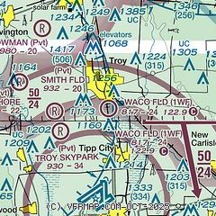
|
| Airport distance calculator |
|---|
|
|
| Sunrise and sunset |
|---|
|
Times for 10-Dec-2025
| | Local
(UTC-5) | | Zulu
(UTC) |
|---|
| Morning civil twilight | | 07:18 | | 12:18 |
| Sunrise | | 07:49 | | 12:49 |
| Sunset | | 17:10 | | 22:10 |
| Evening civil twilight | | 17:41 | | 22:41 |
|
| Current date and time |
|---|
| Zulu (UTC) | 11-Dec-2025 02:32:45 |
|---|
| Local (UTC-5) | 10-Dec-2025 21:32:45 |
|---|
|
| METAR |
|---|
KDAY
7nm S | 110156Z 30010KT 10SM FEW016 BKN039 M01/M04 A2978 RMK AO2 SLP093 T10061044 $
|
KFFO
14nm SE | 110155Z 31007KT 10SM SCT023 BKN043 02/M02 A2977 RMK AO2A SLP089 T00221016
|
KVES
19nm NW | 110215Z AUTO 30010KT 10SM BKN030 BKN035 OVC043 M01/M02 A2978 RMK AO2
|
|
| TAF |
|---|
KDAY
7nm S | 101742Z 1018/1118 26018G30KT P6SM BKN022 TEMPO 1020/1023 4SM -SHSNRA BKN008 FM102300 32015G27KT P6SM OVC011 PROB30 1023/1103 4SM -SHSN BKN008 FM110300 30015G23KT P6SM OVC020 FM111000 29008KT P6SM BKN018
|
KFFO
14nm SE | 101910Z 1019/1201 26012G18KT 9999 VCSH SCT015 BKN020 OVC040 610206 510002 QNH2945INS WND 220V350 TEMPO 1019/1023 28025G35KT SCT009 BKN015 OVC040 520002 BECMG 1022/1023 32012G18KT 6000 -SN BKN015 OVC030 620158 510003 QNH2963INS TEMPO 1023/1103 28015G25KT BECMG 1102/1103 30012G18KT 9000 -SN SCT015 OVC020 620208 510152 QNH2979INS BECMG 1112/1113 27012KT 9999 NSW SCT009 BKN020 620202 QNH2994INS BECMG 1200/1201 26009KT 9000 -SN BKN015 OVC020 620206 QNH2996INS TX05/1019Z TNM01/1117Z
|
|
| NOTAMs |
|---|
NOTAMs are issued by the DoD/FAA and will open in a separate window not controlled by AirNav.
|
|


