FAA INFORMATION EFFECTIVE 09 JULY 2026
Location
| FAA Identifier: | D15 |
| Lat/Long: | 43-38-40.1020N 084-58-55.0860W
43-38.668367N 084-58.918100W
43.6444728,-84.9819683
(estimated) |
| Elevation: | 886 ft. / 270.1 m (surveyed) |
| Variation: | 05W (1985) |
| From city: | 1 mile E of LAKE ISABELLA, MI |
| Time zone: | UTC -4 (UTC -5 during Standard Time) |
| Zip code: | 48893 |
Airport Operations
| Airport use: | Open to the public |
| Activation date: | 12/1970 |
| Control tower: | no |
| ARTCC: | MINNEAPOLIS CENTER |
| FSS: | LANSING FLIGHT SERVICE STATION |
| NOTAMs facility: | LAN (NOTAM-D service available) |
| Attendance: | UNATNDD |
| Wind indicator: | yes |
| Segmented circle: | no |
| Lights: | SS-SR |
Airport Communications
| CTAF/UNICOM: | 122.8 |
| WX AWOS-3P at MOP (11 nm E): | 133.025 (989-773-2885) |
Nearby radio navigation aids
| VOR radial/distance | | VOR name | | Freq | | Var |
|---|
| MBSr283/39.9 | | SAGINAW VOR/DME | | 114.35 | | 03W |
Airport Services
Runway Information
Runway 11/29
| Dimensions: | 2582 x 50 ft. / 787 x 15 m |
| Surface: | asphalt, in good condition |
| Runway edge lights: | low intensity
NSTD LIRL DUE TO NON FAA APVD FIXTURES; LCTD 53 FT NORTH & 34 FT SOUTH OF RWY EDGE. |
| RUNWAY 11 | | RUNWAY 29 |
| Latitude: | 43-38.702167N | | 43-38.634167N |
| Longitude: | 084-59.205333W | | 084-58.630500W |
| Elevation: | 886.0 ft. | | 886.0 ft. |
| Traffic pattern: | left | | left |
| Displaced threshold: | 1089 ft. | | 717 ft. |
| Markings: | basic, in good condition | | basic, in good condition |
| Obstructions: | 74 ft. tree, 267 ft. from runway, 85 ft. left of centerline
17 FT ROAD, 41-90 FT DIST; 20 FT BLDG, 144 FT DIST, 105 FT R; 20 FT BLDG, 177 FT DIST, 120 FT L; 50 FT TREE, 199 FT DIST, 100 FT R. | | 32 ft. trees, 201 ft. from runway
15 FT ROAD, 36-83 FT DIST; 15 FT BRUSH, 40 FT DIST. |
Airport Ownership and Management from official FAA records
| Ownership: | Publicly-owned |
| Owner: | VILLAGE OF LAKE ISABELLA
1010 CLUBHOUSE DR
LAKE ISABELLA, MI 48893-9339
Phone 989-644-8654 |
| Manager: | TOM COURSER
1010 CLUBHOUSE DR
LAKE ISABELLA, MI 48893-9339
Phone 989-644-2504
CELL 989-621-3628. |
Additional Remarks
| - | SNOW REMOVAL IREG - FOR ARPT CONDS CALL OWNER OR AMGR. |
| - | FOR CD CTC MINNEAPOLIS ARTCC AT 651-463-5588. |
Instrument Procedures
There are no published instrument procedures at D15.
Some nearby airports with instrument procedures:
KMOP - Mount Pleasant Municipal Airport (11 nm E)
48D - Clare Municipal Airport (15 nm NE)
13C - Lakeview Airport/Griffith Field (17 nm SW)
KRQB - Roben-Hood Airport (23 nm W)
KAMN - Gratiot Community Airport (23 nm SE)
|
|

Road maps at:
MapQuest
Bing
Google
| Aerial photo |
|---|
WARNING: Photo may not be current or correct
 Photo by Roy Carlson, Plainwell MI
Photo taken 09-Oct-2005
Photo by Roy Carlson, Plainwell MI
Photo taken 09-Oct-2005
Do you have a better or more recent aerial photo of Lake Isabella/Cal Brewer Memorial Airport that you would like to share? If so, please send us your photo.
|
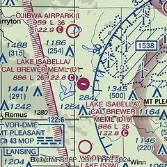
| Sectional chart |
|---|
|
| Airport distance calculator |
|---|
|
|
| Sunrise and sunset |
|---|
|
Times for 13-Jul-2026
| | Local
(UTC-4) | | Zulu
(UTC) |
|---|
| Morning civil twilight | | 05:37 | | 09:37 |
| Sunrise | | 06:11 | | 10:11 |
| Sunset | | 21:20 | | 01:20 |
| Evening civil twilight | | 21:55 | | 01:55 |
|
| Current date and time |
|---|
| Zulu (UTC) | 13-Jul-2026 11:12:31 |
|---|
| Local (UTC-4) | 13-Jul-2026 07:12:31 |
|---|
|
| METAR |
|---|
KMOP
11nm E | 131055Z AUTO 16006KT 10SM -RA SCT075 SCT100 SCT120 21/16 A3010 RMK AO2 T02080164
|
|
| TAF |
|---|
KMBS
40nm E | 130806Z 1308/1406 VRB03KT P6SM SCT120 BKN250 FM130900 21003KT P6SM BKN090 FM131400 24009KT P6SM SCT250 FM131900 26011KT P6SM FEW045 SCT250 FM140100 25006KT P6SM SCT250
|
|
| NOTAMs |
|---|
NOTAMs are issued by the DoD/FAA and will open in a separate window not controlled by AirNav.
|
|

