FAA INFORMATION EFFECTIVE 27 NOVEMBER 2025
Location
| FAA Identifier: | CPK |
| Lat/Long: | 36-39-56.2230N 076-19-14.3610W
36-39.937050N 076-19.239350W
36.6656175,-76.3206558
(estimated) |
| Elevation: | 18.7 ft. / 5.7 m (surveyed) |
| Variation: | 11W (2010) |
| From city: | 12 miles S of NORFOLK, VA |
| Time zone: | UTC -5 (UTC -4 during Daylight Saving Time) |
| Zip code: | 23323 |
Airport Operations
| Airport use: | Open to the public |
| Control tower: | no |
| ARTCC: | WASHINGTON CENTER |
| FSS: | LEESBURG FLIGHT SERVICE STATION |
| NOTAMs facility: | CPK (NOTAM-D service available) |
| Attendance: | 0800-2000 |
| Pattern altitude: | TPA 1000FT AGL (1020 FT MSL) TURBINE/LARGE ACFT 1500 FT AGL (1520 FT MSL). |
| Wind indicator: | lighted |
| Segmented circle: | yes |
| Lights: | ACTVT HIRL RY 05/23, MALSR RY 05 AND REIL RY 23 - CTAF. |
| Beacon: | white-green (lighted land airport)
Operates sunset to sunrise. |
Airport Communications
| CTAF/UNICOM: | 123.075 |
| WX AWOS-3: | 123.675 (757-204-4290) |
| NORFOLK APPROACH: | 118.9 125.2 |
| NORFOLK DEPARTURE: | 118.9 125.2 |
| DRONE STAR: | 118.9 |
| TERKS STAR: | 118.9 |
| WX AWOS-3PT at PVG (9 nm NW): | 118.375 (757-465-2175) |
| WX AWOS-3 at SFQ (13 nm W): | 119.375 (757-934-3942) |
| WX ASOS at ORF (15 nm NE): | PHONE 276-200-0952 |
| WX ASOS at NTU (17 nm NE): | PHONE DSN 433-3619 or 757-433-3619 |
Nearby radio navigation aids
| VOR radial/distance | | VOR name | | Freq | | Var |
|---|
| ORFr210/14.8 | | NORFOLK VORTAC | | 116.90 | | 07W |
| ECGr351/25.5 | | ELIZABETH CITY VOR/DME | | 115.75 | | 07W |
| CVIr066/31.8 | | COFIELD VORTAC | | 114.60 | | 09W |
| NDB name | | Hdg/Dist | | Freq | | Var | | ID |
|---|
| WOODVILLE | | 007/24.2 | | 254 | | 10W | | LLW | .-.. .-.. .-- |
| WAKEFIELD | | 131/37.8 | | 274 | | 11W | | AKQ | .- -.- --.- |
Airport Services
| Fuel available: | 100LL JET-A
A:FOR FUEL AFT HRS CALL IN ADVANCE 757-421-9000. SELF-SVC AVBL.
100LL:FOR FUEL AFTER HRS CALL 757-421-9000. |
| Parking: | hangars and tiedowns |
| Airframe service: | MAJOR |
| Powerplant service: | MAJOR |
Runway Information
Runway 5/23
| Dimensions: | 5500 x 100 ft. / 1676 x 30 m |
| Surface: | asphalt/grooved, in good condition |
| Weight bearing capacity: | |
| Runway edge lights: | high intensity |
| RUNWAY 5 | | RUNWAY 23 |
| Latitude: | 36-39.574645N | | 36-40.299432N |
| Longitude: | 076-19.577148W | | 076-18.901512W |
| Elevation: | 16.5 ft. | | 18.4 ft. |
| Traffic pattern: | left | | right |
| Runway heading: | 047 magnetic, 036 true | | 227 magnetic, 216 true |
| Markings: | precision, in good condition | | nonprecision, in good condition |
| Visual slope indicator: | 4-light PAPI on left (3.00 degrees glide path) | | 4-light PAPI on left (3.00 degrees glide path) |
| Approach lights: | MALSR: 1,400 foot medium intensity approach lighting system with runway alignment indicator lights | | |
| Runway end identifier lights: | no | | yes |
| Touchdown point: | yes, no lights | | yes, no lights |
| Instrument approach: | ILS/DME | | |
| Obstructions: | 27 ft. tree, 490 ft. from runway, 285 ft. right of centerline, 10:1 slope to clear
18 FT TREE 276 FT R OF CNTRLN. | | 28 ft. tree, 443 ft. from runway, 247 ft. left of centerline, 8:1 slope to clear |
Airport Ownership and Management from official FAA records
| Ownership: | Publicly-owned |
| Owner: | CHESAPEAKE AIRPORT AUTHORITY
2800 AIRPORT DRIVE
CHESAPEAKE, VA 23323-6402
Phone 757-432-8110 |
| Manager: | CHRIS SCHRANTZ
2800 AIRPORT DRIVE
CHESAPEAKE, VA 23323-6402
Phone 757-432-8110 |
Additional Remarks
| - | DEER AND GEESE ON & INVOF RY. |
| - | GCO AVBL ON FREQ 135.075 THRU NORFOLK CD. IF UN, FOR CD CTC NORFOLK APCH AT 757-464-0757. |
| - | NOISE ABATEMENT PROCEDURES IN EFFECT; CTC AMGR 757-432-8110. |
Instrument Procedures
NOTE: All procedures below are presented as PDF files. If you need a reader for these files, you should download the free Adobe Reader.NOT FOR NAVIGATION. Please procure official charts for flight.
FAA instrument procedures published for use from 27 November 2025 at 0901Z to 25 December 2025 at 0900Z.
STARs - Standard Terminal Arrivals |
|---|
| DRONE TWO | |
2 pages:
[1] [2] (264KB) |
| TERKS TWO | |
download (167KB) |
IAPs - Instrument Approach Procedures |
|---|
| ILS OR LOC RWY 05 **CHANGED** | |
download (273KB) |
| RNAV (GPS) RWY 05 **CHANGED** | |
download (255KB) |
| RNAV (GPS) RWY 23 **CHANGED** | |
download (224KB) |
| NOTE: Special Alternate Minimums apply **CHANGED** | |
download (166KB) |
| NOTE: Special Take-Off Minimums/Departure Procedures apply | |
download (140KB) |
Other nearby airports with instrument procedures:
KPVG - Hampton Roads Executive Airport (9 nm NW)
KSFQ - Suffolk Executive Airport (13 nm W)
KORF - Norfolk International Airport (15 nm NE)
KNGU - Norfolk Naval Station (Chambers Field) (16 nm N)
KNTU - Oceana Naval Air Station (Apollo Soucek Field) (17 nm NE)
KNHU - Norfolk Naval Station Airport (17 nm N)
|
|

Road maps at:
MapQuest
Bing
Google
| Aerial photo |
|---|
WARNING: Photo may not be current or correct
 Photo by Sheila Beaton
Photo taken 23-Mar-2013
looking north.
Photo by Sheila Beaton
Photo taken 23-Mar-2013
looking north.
Do you have a better or more recent aerial photo of Chesapeake Regional Airport that you would like to share? If so, please send us your photo.
|
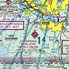
| Sectional chart |
|---|
|
CAUTION: Diagram may not be current

| Airport distance calculator |
|---|
|
|
| Sunrise and sunset |
|---|
|
Times for 12-Dec-2025
| | Local
(UTC-5) | | Zulu
(UTC) |
|---|
| Morning civil twilight | | 06:40 | | 11:40 |
| Sunrise | | 07:09 | | 12:09 |
| Sunset | | 16:49 | | 21:49 |
| Evening civil twilight | | 17:18 | | 22:18 |
|
| Current date and time |
|---|
| Zulu (UTC) | 12-Dec-2025 17:46:10 |
|---|
| Local (UTC-5) | 12-Dec-2025 12:46:10 |
|---|
|
| METAR |
|---|
| KCPK | 121735Z AUTO 03004KT 10SM SCT060 BKN090 OVC110 04/M07 A3013 RMK AO2 T00441068
|
KNFE
9nm E | 121658Z AUTO 00000KT 10SM OVC070 04/M06 A3015 RMK AO2 SLP211 T00391061
|
KPVG
9nm NW | 121656Z AUTO 00000KT 10SM BKN070 OVC110 04/M07 A3016 RMK AO2 SLP213 T00391067 $
|
KSFQ
13nm W | 121735Z AUTO 00000KT 10SM SCT060 BKN090 OVC110 05/M05 A3015 RMK AO2 T00481053
|
KORF
15nm N | 121651Z 36006KT 10SM BKN080 04/M07 A3015 RMK AO2 SLP208 T00391067
|
KNGU
15nm N | 121659Z VRB05KT 10SM BKN080 BKN200 03/M08 A3018 RMK AO2 SLP218 T00331078
|
KNTU
17nm NE | 121656Z 33006KT 10SM OVC075 04/M06 A3014 RMK AO2 SLP209 T00441061
|
|
| TAF |
|---|
KORF
15nm N | 121120Z 1212/1312 VRB03KT P6SM BKN250 FM121400 04005KT P6SM BKN050
|
KNGU
15nm N | 1215/1315 35004KT 9999 SCT050 BKN090 OVC220 640109 641006 541809 522709 523603 QNH3011INS FM122300 VRB03KT 9999 SCT090 BKN250 640109 641006 541809 522709 523603 QNH3016INS FM131300 21006KT 9999 SCT070 SCT250 QNH3003INS TX05/1219Z TNM01/1311Z FN20004
|
KNTU
17nm NE | 1123/1223 30006KT 9999 FEW050 QNH2986INS FM121000 VRB04KT 9999 SCT040 BKN120 BKN250 QNH2997INS FM121300 VRB06KT 9999 BKN080 OVC120 QNH3006INS FM121900 35006KT 9999 BKN050 OVC100 QNH3007INS TX06/1218Z TNM02/1210Z COR 0556 FS30237
|
|
| NOTAMs |
|---|
NOTAMs are issued by the DoD/FAA and will open in a separate window not controlled by AirNav.
|
|


