FAA INFORMATION EFFECTIVE 10 JULY 2025
Location
| FAA Identifier: | RIC |
| Lat/Long: | 37-30-18.6520N 077-19-11.0590W
37-30.310867N 077-19.184317W
37.5051811,-77.3197386
(estimated) |
| Elevation: | 167.5 ft. / 51.1 m (surveyed) |
| Variation: | 10W (2020) |
| From city: | 6 miles E of RICHMOND, VA |
| Time zone: | UTC -4 (UTC -5 during Standard Time) |
| Zip code: | 23250 |
Airport Operations
| Airport use: | Open to the public |
| Activation date: | 12/1931 |
| Control tower: | yes |
| ARTCC: | WASHINGTON CENTER |
| FSS: | LEESBURG FLIGHT SERVICE STATION |
| NOTAMs facility: | RIC (NOTAM-D service available) |
| Attendance: | CONTINUOUS |
| Pattern altitude: | TPA - 1033 AGL SINGLE ENGINE, LGT ACFT, 1533 AGL ALL OTHERS. |
| Wind indicator: | lighted |
| Segmented circle: | no |
| Lights: | SS-SR |
| Beacon: | white-green (lighted land airport)
Operates sunset to sunrise. |
| Landing fee: | yes |
| Fire and rescue: | ARFF index C |
| Airline operations: | ARFF INDEX D/E AVBL UPON REQUEST. |
| International operations: | customs landing rights airport |
Airport Communications
| UNICOM: | 122.95 |
| ATIS: | 119.15 263.025 |
| WX ASOS: | PHONE 804-223-6573 |
| RICHMOND GROUND: | 121.9 348.6 |
| RICHMOND TOWER: | 121.1 257.8 |
| POTOMAC APPROACH: | 126.4 ;001-185 126.75 ;186-360 118.2 |
| POTOMAC DEPARTURE: | 126.4 ;001-185 126.75 ;186-360 |
| CLEARANCE DELIVERY: | 127.55 348.6 |
| PRE-TAXI CLEARANCE: | 127.55 348.6 |
| ARNG OPS: | 142.125 365.95 41.525 |
| CLASS C: | 126.4 ;001-185 126.75 ;186-360 |
| CLASS C/S: | 118.2 |
| COLIN DP: | 126.4 |
| DUCXS STAR: | 126.75 |
| EMERG: | 121.5 243.0 |
| KALLI DP: | 126.75 |
| LUCYL DP: | 126.4 |
| POWTN STAR: | 126.75 |
| SPIDR STAR: | 126.75 |
| WX AWOS-3 at W96 (9 nm E): | 119.875 (804-932-8863) |
| WX AWOS-3PT at FCI (11 nm SW): | 128.625 (804-271-8426) |
| WX ASOS at OFP (13 nm NW): | 119.025 (804-752-2902) |
Nearby radio navigation aids
| VOR radial/distance | | VOR name | | Freq | | Var |
|---|
| RIC at field | | RICHMOND VORTAC | | 114.10 | | 09W |
| HPWr323/14.4 | | HOPEWELL VORTAC | | 114.35 | | 06W |
| FAKr099/24.2 | | FLAT ROCK VORTAC | | 113.30 | | 06W |
| HCMr284/29.2 | | HARCUM VORTAC | | 108.80 | | 07W |
| NDB name | | Hdg/Dist | | Freq | | Var | | ID |
|---|
| WAKEFIELD | | 345/34.8 | | 274 | | 11W | | AKQ | .- -.- --.- |
Airport Services
| Fuel available: | 100LL JET-A |
| Parking: | hangars and tiedowns |
| Airframe service: | MAJOR |
| Powerplant service: | MAJOR |
| Bottled oxygen: | HIGH/LOW |
| Bulk oxygen: | NONE |
Runway Information
Runway 16/34
| Dimensions: | 9003 x 150 ft. / 2744 x 46 m |
| Surface: | asphalt/grooved, in good condition |
| Weight bearing capacity: | | Single wheel: | 125.0 | | Double wheel: | 238.0 | | Double tandem: | 409.0 | | Dual double tandem: | 944.0 |
|
| Runway edge lights: | high intensity |
| RUNWAY 16 | | RUNWAY 34 |
| Latitude: | 37-30.998187N | | 37-29.747552N |
| Longitude: | 077-19.414595W | | 077-18.413082W |
| Elevation: | 166.9 ft. | | 160.5 ft. |
| Traffic pattern: | left | | left |
| Runway heading: | 157 magnetic, 147 true | | 337 magnetic, 327 true |
| Declared distances: | TORA:9003 TODA:9003 ASDA:9003 LDA:9003 | | TORA:9003 TODA:9003 ASDA:9003 LDA:9003 |
| Markings: | precision, in good condition | | precision, in good condition |
| Visual slope indicator: | 4-light PAPI on left (3.00 degrees glide path) | | 4-light PAPI on left (3.00 degrees glide path) |
| RVR equipment: | touchdown, midfield, rollout | | touchdown, midfield, rollout |
| Approach lights: | MALSR: 1,400 foot medium intensity approach lighting system with runway alignment indicator lights | | ALSF2: standard 2,400 foot high intensity approach lighting system with centerline sequenced flashers (category II or III) |
| Centerline lights: | yes | | yes |
| Touchdown point: | yes, no lights | | yes, lighted |
| Instrument approach: | ILS | | ILS |
Runway 2/20
| Dimensions: | 6607 x 150 ft. / 2014 x 46 m |
| Surface: | asphalt/grooved, in excellent condition |
| Weight bearing capacity: | | Single wheel: | 120.0 | | Double wheel: | 250.0 | | Double tandem: | 480.0 | | Dual double tandem: | 1034.0 |
|
| Runway edge lights: | high intensity |
| RUNWAY 2 | | RUNWAY 20 |
| Latitude: | 37-29.932348N | | 37-30.991123N |
| Longitude: | 077-19.779457W | | 077-19.461292W |
| Elevation: | 158.6 ft. | | 165.3 ft. |
| Traffic pattern: | left | | left |
| Runway heading: | 023 magnetic, 013 true | | 203 magnetic, 193 true |
| Declared distances: | TORA:6607 TODA:6607 ASDA:6607 LDA:6607 | | TORA:6607 TODA:6607 ASDA:6607 LDA:6607 |
| Markings: | precision, in good condition | | precision, in good condition |
| Visual slope indicator: | 4-light PAPI on left (3.00 degrees glide path) | | 4-light PAPI on left (3.00 degrees glide path) |
| Approach lights: | MALSR: 1,400 foot medium intensity approach lighting system with runway alignment indicator lights | | |
| Runway end identifier lights: | no | | yes |
| Touchdown point: | yes, no lights | | yes, no lights |
| Instrument approach: | LOC/GS | | |
| Obstructions: | 90 ft. pole, lighted, 3300 ft. from runway, 450 ft. left of centerline, 34:1 slope to clear | | 67 ft. tree, 2400 ft. from runway, 650 ft. left of centerline, 33:1 slope to clear |
Airport Ownership and Management from official FAA records
| Ownership: | Publicly-owned |
| Owner: | CAPITAL REGION ARPT COMM.
1 RICHARD E BYRD TERMINAL DR
RICHMOND, VA 23250
Phone 804-226-3000 |
| Manager: | PERRY J. MILLER
1 RICHARD E BYRD TERMINAL DR
RICHMOND, VA 23250
Phone (804) 226-3001 |
Additional Remarks
| A39-02/20 | PCR VALUE: 820/F/C/X/T |
| A39-16/34 | PCR VALUE: 600/F/B/X/T |
| - | NO TURBOJET ACFT PRACTICE LDGS 2200-0700. |
| - | TWY V BTN TWY A & TWY R RSTRD FM USE BY ACFT WITH WINGSPANS GREATER THAN 99 FT. |
| - | NO TAXIING BTN PUSHED BACK ACFT AND THE TRML ON THE ACR RAMP. |
| - | DUE TO OPR CONSTRAINTS ACFT PUSHED BACK FOR DEP PROHIBITED FM HLDG ON ACR RAMPS FOR MORE THAN 5 MINS. |
| - | CONS CONST ON ARPT; BE ALERT FOR FREQ RWY & TWY CLOSURES. |
| - | ATC CLNC RQRD FOR PUSHBACKS FROM GATES A6, A8, A10, A12, A14, B5, B7, B9, B11, B13 ONTO TWY A. |
| - | ATC CLNC RQRD FOR PUSHBACK FROM HARDSTANDS C9, C10 AND C12 ONTO TWY T. |
| - | ARPT SFC COND NOT MNTD 0000 TO 0600 LCL TIME. |
| - | FOR AIRFIELD INFO OR ARPT OPNS CALL 804-226-0001. |
| - | BIRD ACT INVOF ALL RWYS & TWYS & INVOF ARPT. |
| - | ACR APRON CLSD TO UNSKED ACFT WEIGHING UNDER 35000 LBS. |
| - | NO EDGE LGTS ON N/S SECTION OF TWY V - REFLECTORS ONLY. |
| - | HOLD LINE RWY 20 EAST SIDE LCTD ACROSS RWY 34 150 FT FM DEP END. HOLD LINE RWY 20 WEST SIDE ACROSS TWY A & ALSO SERVES AS HOLD LINE FOR RWY 16; SIGNAGE INDICATES BOTH RWYS. |
| - | NON-RDO EQUIPPED VEHICLES CROSSING MIDFIELD TWYS C, E AND H AND DRIVING ON TWY L. |
| - | THE FOLLOWING AREAS ARE NOT VISIBLE FROM THE TWR: PORTIONS OF THE ACR APRON; ANG ACFT PRKG RAMP. |
| - | DUE TO THE CLOSE PROXIMITY TO RWY 02/20, TWY UNIFORM SIGNAGE MAY BE BEHIND ACFT, ONCE CLEAR OF RWY 02/20. |
| - | RIC HAS FACILITY CONSTRAINTS THAT LIMIT ITS ABILITY TO ACCOMMODATE DIVERTED FLTS AND STRONGLY ENCOURAGES ACFT OPRS TO CTC ARPT OPNS AT 804-226-0001 FOR PRIOR CDN OF DIVERTED FLTS, EXCEPT IN THE CASE OF A DECLARED IN-FLIGHT EMERG. |
Instrument Procedures
NOTE: All procedures below are presented as PDF files. If you need a reader for these files, you should download the free Adobe Reader.NOT FOR NAVIGATION. Please procure official charts for flight.
FAA instrument procedures published for use from 10 July 2025 at 0901Z to 07 August 2025 at 0900z.
STARs - Standard Terminal Arrivals |
|---|
| DUCXS FIVE (RNAV) | |
download (159KB) |
| POWTN FIVE (RNAV) | |
download (192KB) |
| SPIDR FIVE (RNAV) | |
download (178KB) |
| SPIDR FIVE (RNAV) | |
download (178KB) |
IAPs - Instrument Approach Procedures |
|---|
| ILS OR LOC RWY 02 | |
download (303KB) |
| ILS OR LOC RWY 16 | |
download (321KB) |
| ILS OR LOC RWY 34 | |
download (299KB) |
| ILS RWY 34 (SA CAT I) | |
download (272KB) |
| ILS RWY 34 (CAT II - III) | |
download (276KB) |
| RNAV (RNP) Y RWY 02 | |
download (279KB) |
| RNAV (RNP) Y RWY 16 | |
download (266KB) |
| RNAV (RNP) Y RWY 20 | |
download (272KB) |
| RNAV (RNP) Y RWY 34 | |
download (248KB) |
| RNAV (GPS) Z RWY 02 | |
download (282KB) |
| RNAV (GPS) Z RWY 16 | |
download (269KB) |
| RNAV (GPS) Z RWY 20 | |
download (281KB) |
| RNAV (GPS) Z RWY 34 | |
download (264KB) |
| VOR RWY 02 | |
download (254KB) |
| VOR RWY 16 | |
download (256KB) |
| VOR RWY 20 | |
download (259KB) |
| VOR RWY 34 | |
download (253KB) |
| NOTE: Special Alternate Minimums apply | |
download (44KB) |
Departure Procedures |
|---|
| COLIN EIGHT | |
download (249KB) |
| KALLI SEVEN (RNAV) | |
2 pages:
[1] [2] (284KB) |
| LUCYL SIX (RNAV) | |
2 pages:
[1] [2] (329KB) |
| READE SEVEN | |
2 pages:
[1] [2] (331KB) |
| NOTE: Special Take-Off Minimums/Departure Procedures apply | |
download (382KB) |
Other nearby airports with instrument procedures:
W96 - New Kent County Airport (9 nm E)
KFCI - Richmond Executive-Chesterfield County Airport (11 nm SW)
KOFP - Hanover County Municipal Airport (13 nm NW)
KPTB - Tri Cities Executive/Dinwiddie County Airport (21 nm SW)
KFYJ - Middle Peninsula Regional Airport (27 nm E)
|
|

Road maps at:
MapQuest
Bing
Google
| Aerial photo |
|---|
WARNING: Photo may not be current or correct
 Photo by David Minor
Photo taken 08-May-2014
looking west.
Photo by David Minor
Photo taken 08-May-2014
looking west.
Do you have a better or more recent aerial photo of Richmond International Airport that you would like to share? If so, please send us your photo.
|
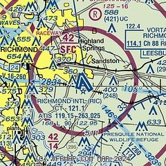
| Sectional chart |
|---|
|
CAUTION: Diagram may not be current
 Download PDF
of official airport diagram from the FAA
| Airport distance calculator |
|---|
|
|
| Sunrise and sunset |
|---|
|
Times for 19-Jul-2025
| | Local
(UTC-4) | | Zulu
(UTC) |
|---|
| Morning civil twilight | | 05:34 | | 09:34 |
| Sunrise | | 06:04 | | 10:04 |
| Sunset | | 20:27 | | 00:27 |
| Evening civil twilight | | 20:57 | | 00:57 |
|
| Current date and time |
|---|
| Zulu (UTC) | 20-Jul-2025 02:17:07 |
|---|
| Local (UTC-4) | 19-Jul-2025 22:17:07 |
|---|
|
| METAR |
|---|
| KRIC | 200154Z 00000KT 10SM FEW009 SCT030 BKN080 24/23 A2998 RMK AO2 RAE02 SLP155 P0000 T02440233
|
KW96
9nm E | 200155Z AUTO 00000KT 10SM CLR 23/23 A2998 RMK AO1 T02330230
|
KFCI
11nm SW | 200156Z AUTO 00000KT 10SM 24/23 A2999 RMK AO2 RAE24 SLP162 P0000 T02390228 $
|
KOFP
13nm NW | 200154Z AUTO 10003KT 9SM BKN120 23/22 A3000 RMK AO2 SLP157 T02280222 $
|
|
| TAF |
|---|
| KRIC | 192108Z 1921/2018 19006KT P6SM VCTS SCT030CB BKN070 TEMPO 1921/1923 VRB15G35KT 2SM TSRA BKN025CB FM200100 20005KT P6SM BKN080 FM200900 23004KT P6SM SCT005 BKN200 FM201500 28008KT P6SM SCT050
|
|
| NOTAMs |
|---|
NOTAMs are issued by the DoD/FAA and will open in a separate window not controlled by AirNav.
|
|


