FAA INFORMATION EFFECTIVE 09 JULY 2026
Location
| FAA Identifier: | Y47 |
| Lat/Long: | 42-30-11.2460N 083-37-25.3250W
42-30.187433N 083-37.422083W
42.5031239,-83.6237014
(estimated) |
| Elevation: | 926.1 ft. / 282 m (estimated) |
| Variation: | 07W (2020) |
| From city: | 1 mile SW of NEW HUDSON, MI |
| Time zone: | UTC -4 (UTC -5 during Standard Time) |
| Zip code: | 48165 |
Airport Operations
| Airport use: | Open to the public |
| Activation date: | 10/1946 |
| Control tower: | no |
| ARTCC: | CLEVELAND CENTER |
| FSS: | LANSING FLIGHT SERVICE STATION |
| NOTAMs facility: | LAN (NOTAM-D service available) |
| Attendance: | MON-FRI 0830-1700, ALL SAT-SUN ON CALL |
| Wind indicator: | lighted |
| Segmented circle: | yes |
| Lights: | ACTVT LIRL RWY 08/26 - CTAF. VASI RWY 08 & 26 OTS INDEFLY. |
| Beacon: | white-green (lighted land airport)
Operates sunset to sunrise. |
Airport Communications
| CTAF/UNICOM: | 122.7 |
| DETROIT APPROACH: | 132.35 |
| DETROIT DEPARTURE: | 132.35 |
| WX ASOS at PTK (13 nm NE): | 125.025 (248-886-8551) |
| WX ASOS at YIP (16 nm S): | PHONE 734-961-6843 |
| WX AWOS-3P at OZW (18 nm NW): | 118.875 (517-546-4450) |
| WX ASOS at ARB (18 nm S): | PHONE 734-668-7173 |
| WX AWOS-3P at VLL (20 nm E): | 119.475 (248-288-4649) |
Nearby radio navigation aids
| VOR radial/distance | | VOR name | | Freq | | Var |
|---|
| SVMr350/5.8 | | SALEM VORTAC | | 114.30 | | 03W |
| DXOr333/20.8 | | DETROIT VOR/DME | | 113.40 | | 06W |
| CRLr348/28.3 | | CARLETON VOR/DME | | 115.70 | | 03W |
| FNTr175/28.3 | | FLINT VORTAC | | 116.90 | | 06W |
Airport Services
| Fuel available: | 100LL |
| Parking: | hangars and tiedowns |
| Bottled oxygen: | NONE |
| Bulk oxygen: | NONE |
Runway Information
Runway 8/26
| Dimensions: | 3128 x 40 ft. / 953 x 12 m |
| Surface: | asphalt, in excellent condition |
| Runway edge lights: | low intensity |
| RUNWAY 8 | | RUNWAY 26 |
| Latitude: | 42-30.104963N | | 42-30.269903N |
| Longitude: | 083-37.751758W | | 083-37.092397W |
| Elevation: | 920.9 ft. | | 926.1 ft. |
| Traffic pattern: | left | | left |
| Runway heading: | 078 magnetic, 071 true | | 258 magnetic, 251 true |
| Displaced threshold: | 867 ft. | | 864 ft. |
| Markings: | basic, in good condition | | basic, in good condition |
| Visual slope indicator: | 2-box VASI on right (4.00 degrees glide path) | | 2-box VASI on left (4.00 degrees glide path) |
| Runway end identifier lights: | no | | no |
| Touchdown point: | yes, no lights | | yes, no lights |
| Obstructions: | 20 ft. brush, 200 ft. from runway, 98 ft. left of centerline
-4 FT DITCH, 40 FT DIST; SCATTERED 5-30 FT TREES & BRUSH, 0-199 FT DIST, 125 FT L & R. | | 79 ft. trees, 200 ft. from runway, 125 ft. right of centerline
15-40 FT TREES & BRUSH, 0-90 FT DIST, 110 FT L. |
Airport Ownership and Management from official FAA records
| Ownership: | Publicly-owned |
| Owner: | OAKLAND COUNTY
6500 PATTERSON PKWY
WATERFORD, MI 48327-1683
Phone 248-437-2333 |
| Manager: | CHERYL BUSH
6500 PATTERSON PKWY
WATERFORD, MI 48327-1683
Phone 248-666-3900 |
Additional Remarks
| - | TREES & BRUSH IN PRIMARY SFC 70-120 FT L & R. |
| - | FOR CD CTC DETROIT APCH AT 734-955-1404. |
| - | DEER & LRG BIRDS ON & INVOF ARPT. |
Instrument Procedures
NOTE: All procedures below are presented as PDF files. If you need a reader for these files, you should download the free Adobe Reader.NOT FOR NAVIGATION. Please procure official charts for flight.
FAA instrument procedures published for use from 09 July 2026 at 0901Z to 06 August 2026 at 0900Z.
IAPs - Instrument Approach Procedures |
|---|
| RNAV (GPS)-A | |
download (146KB) |
| NOTE: Special Take-Off Minimums/Departure Procedures apply | |
download (255KB) |
Other nearby airports with instrument procedures:
1D2 - Canton-Plymouth-Mettetal Airport (12 nm SE)
KPTK - Oakland County International Airport (13 nm NE)
KYIP - Willow Run Airport (16 nm S)
KOZW - Livingston County/Spencer J Hardy Airport (18 nm NW)
KARB - Ann Arbor Municipal Airport (18 nm S)
9G2 - Price's Airport (19 nm N)
KVLL - Oakland/Troy Airport (20 nm E)
|
|

Road maps at:
MapQuest
Bing
Google
| Aerial photo |
|---|
WARNING: Photo may not be current or correct
 Photo by Jeff Franks
Photo taken 13-Jun-2013
looking south.
Photo by Jeff Franks
Photo taken 13-Jun-2013
looking south.
Do you have a better or more recent aerial photo of Oakland Southwest Airport that you would like to share? If so, please send us your photo.
|
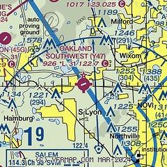
| Sectional chart |
|---|
|
| Airport distance calculator |
|---|
|
|
| Sunrise and sunset |
|---|
|
Times for 18-Jul-2026
| | Local
(UTC-4) | | Zulu
(UTC) |
|---|
| Morning civil twilight | | 05:41 | | 09:41 |
| Sunrise | | 06:14 | | 10:14 |
| Sunset | | 21:07 | | 01:07 |
| Evening civil twilight | | 21:41 | | 01:41 |
|
| Current date and time |
|---|
| Zulu (UTC) | 18-Jul-2026 11:36:32 |
|---|
| Local (UTC-4) | 18-Jul-2026 07:36:32 |
|---|
|
| METAR |
|---|
KPTK
13nm NE | 181101Z AUTO 25008KT 6SM BR SCT006 23/22 A2984 RMK AO2 T02280222
|
KOZW
17nm NW | 181115Z AUTO 23008KT 6SM BR CLR 23/22 A2983 RMK AO2
|
KYIP
17nm S | 181119Z AUTO 22011KT 4SM BR BKN005 23/22 A2985 RMK AO2 CIG 004V009 T02280217
|
KARB
18nm S | 734-668-7173
181053Z AUTO RMK AO2 SLPNO PWINO $
|
KVLL
20nm E | 181115Z AUTO 23007KT 5SM BR OVC006 23/22 A2982 RMK AO2
|
KDTW
21nm SE | 181053Z 22009KT 3SM FU BKN005 BKN200 23/22 A2986 RMK AO2 SLP106 FU BKN005 T02280217 $
|
|
| TAF |
|---|
KPTK
13nm NE | 180538Z 1806/1906 21008KT 3SM HZ SCT045 FM180700 22008KT 6SM HZ SCT045 BKN200 FM181400 24014G23KT P6SM SCT030 BKN050 OVC120 PROB30 1816/1819 3SM TSRA OVC030CB FM181900 33014G24KT P6SM SCT045 BKN060 FM190100 02010KT P6SM BKN200
|
KYIP
17nm S | 180538Z 1806/1906 21008KT 3SM HZ SCT045 FM180700 22008KT 6SM HZ SCT045 BKN200 FM181500 26016G23KT P6SM SCT030 BKN050 OVC120 TEMPO 1817/1820 2SM TSRA OVC030CB FM182100 32014G22KT P6SM SCT045 BKN060 FM190100 02010KT P6SM BKN200
|
|
| NOTAMs |
|---|
NOTAMs are issued by the DoD/FAA and will open in a separate window not controlled by AirNav.
|
|

