FAA INFORMATION EFFECTIVE 23 JANUARY 2025
Location
| FAA Identifier: | VLL |
| Lat/Long: | 42-32-34.6000N 083-10-40.4000W
42-32.576667N 083-10.673333W
42.5429444,-83.1778889
(estimated) |
| Elevation: | 727.2 ft. / 221.7 m (surveyed) |
| Variation: | 06W (1995) |
| From city: | 2 miles E of TROY, MI |
| Time zone: | UTC -5 (UTC -4 during Daylight Saving Time) |
| Zip code: | 48084 |
Airport Operations
| Airport use: | Open to the public |
| Control tower: | no |
| ARTCC: | CLEVELAND CENTER |
| FSS: | LANSING FLIGHT SERVICE STATION |
| NOTAMs facility: | VLL (NOTAM-D service available) |
| Attendance: | 0800-1800 |
| Pattern altitude: | 1727.2 ft. MSL |
| Wind indicator: | lighted |
| Segmented circle: | no |
| Lights: | ACTVT PAPI RWY 10 & 28; MIRL RWY 10/28 - CTAF. |
| Beacon: | white-green (lighted land airport)
Operates sunset to sunrise. |
| Landing fee: | yes |
Airport Communications
| CTAF/UNICOM: | 123.05 |
| WX AWOS-3: | 119.475 (248-288-4649) |
| DETROIT APPROACH: | 132.35 |
| DETROIT DEPARTURE: | 132.35 |
| WX ASOS at DET (11 nm SE): | PHONE 313-371-9696 |
| WX ASOS at PTK (13 nm NW): | 125.025 (248-886-8551) |
Nearby radio navigation aids
| VOR radial/distance | | VOR name | | Freq | | Var |
|---|
| SVMr069/20.1 | | SALEM VORTAC | | 114.30 | | 03W |
| DXOr029/21.5 | | DETROIT VOR/DME | | 113.40 | | 06W |
| CRLr026/32.2 | | CARLETON VOR/DME | | 115.70 | | 03W |
| FNTr141/35.7 | | FLINT VORTAC | | 116.90 | | 06W |
| NDB name | | Hdg/Dist | | Freq | | Var | | ID |
|---|
| GROSSE ILE | | 005/26.5 | | 419 | | 07W | | RYS | .-. -.-- ... |
Airport Services
| Fuel available: | 100LL JET-A+ |
| Parking: | hangars and tiedowns |
| Airframe service: | NONE |
| Powerplant service: | NONE |
Runway Information
Runway 10/28
| Dimensions: | 3549 x 60 ft. / 1082 x 18 m |
| Surface: | asphalt, in excellent condition |
| Runway edge lights: | medium intensity |
| RUNWAY 10 | | RUNWAY 28 |
| Latitude: | 42-32.575973N | | 42-32.578848N |
| Longitude: | 083-11.068925W | | 083-10.278788W |
| Elevation: | 727.0 ft. | | 701.0 ft. |
| Traffic pattern: | left | | left |
| Runway heading: | 096 magnetic, 090 true | | 276 magnetic, 270 true |
| Markings: | nonprecision, in good condition | | nonprecision, in good condition |
| Visual slope indicator: | 2-light PAPI on right (3.75 degrees glide path) | | 2-light PAPI on left (3.75 degrees glide path) |
| Runway end identifier lights: | no | | no |
| Touchdown point: | yes, no lights | | yes, no lights |
| Obstructions: | 21 ft. tree, 200 ft. from runway, 166 ft. left of centerline, 1:1 slope to clear | | 9 ft. tree, 200 ft. from runway, 167 ft. left of centerline, 1:1 slope to clear |
Airport Ownership and Management from official FAA records
| Ownership: | Publicly-owned |
| Owner: | OAKLAND COUNTY
6500 PATTERSON PKWY
WATERFORD, MI 48327-1683
Phone 248-666-3900 |
| Manager: | CHERYL BUSH
6500 PATTERSON PKWY
WATERFORD, MI 48327-1683
Phone 248-666-3900
ARPT PHYS ADS: 2672 INDUSTRIAL ROW DR, TROY, MI 48084. |
Additional Remarks
| - | DEER & LRG BIRDS ON & INVOF ARPT. |
| - | NO TGL OR PRACTICE TFC PATTERNS. |
| - | FOR CD CTC DETROIT APCH AT 734-955-1404. |
Instrument Procedures
NOTE: All procedures below are presented as PDF files. If you need a reader for these files, you should download the free Adobe Reader.NOT FOR NAVIGATION. Please procure official charts for flight.
FAA instrument procedures published for use from 23 January 2025 at 0901Z to 20 February 2025 at 0900z.
STARs - Standard Terminal Arrivals |
|---|
| FOREY TWO (RNAV) | |
download (160KB) |
| OKLND ONE (RNAV) | |
download (145KB) |
| PETTE TWO (RNAV) | |
download (210KB) |
| RRALF THREE (RNAV) | |
download (161KB) |
IAPs - Instrument Approach Procedures |
|---|
| RNAV (GPS) RWY 10 | |
download (186KB) |
| NOTE: Special Alternate Minimums apply | |
download (138KB) |
Departure Procedures |
|---|
| BARII THREE (RNAV) | |
download (155KB) |
| CCOBB THREE (RNAV) | |
download (192KB) |
| CLVIN THREE (RNAV) | |
download (175KB) |
| HHOWE FOUR (RNAV) | |
download (180KB) |
| KAYLN THREE (RNAV) | |
download (161KB) |
| KZLOV TWO (RNAV) | |
download (154KB) |
| LIDDS THREE (RNAV) | |
download (170KB) |
| MIGGY THREE (RNAV) | |
download (193KB) |
| PAVYL THREE (RNAV) | |
download (169KB) |
| SNDRS THREE (RNAV) | |
download (207KB) |
| TRMML FOUR (RNAV) | |
download (159KB) |
| ZETTR FOUR (RNAV) | |
download (201KB) |
| NOTE: Special Take-Off Minimums/Departure Procedures apply | |
download (346KB) |
Other nearby airports with instrument procedures:
KDET - Coleman A Young Municipal Airport (11 nm SE)
KPTK - Oakland County International Airport (13 nm NW)
KMTC - Selfridge Air National Guard Base (16 nm E)
1D2 - Canton-Plymouth-Mettetal Airport (17 nm SW)
57D - Ray Community Airport (17 nm NE)
D98 - Romeo State Airport (18 nm NE)
Y47 - Oakland Southwest Airport (20 nm W)
|
|

Road maps at:
MapQuest
Bing
Google
| Aerial photo |
|---|
WARNING: Photo may not be current or correct
 Photo by Jeff Schuster
Photo taken 29-Jun-2014
looking west.
Photo by Jeff Schuster
Photo taken 29-Jun-2014
looking west.
Do you have a better or more recent aerial photo of Oakland/Troy Airport that you would like to share? If so, please send us your photo.
|
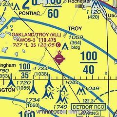
| Sectional chart |
|---|
|
| Airport distance calculator |
|---|
|
|
| Sunrise and sunset |
|---|
|
Times for 06-Feb-2025
| | Local
(UTC-5) | | Zulu
(UTC) |
|---|
| Morning civil twilight | | 07:13 | | 12:13 |
| Sunrise | | 07:42 | | 12:42 |
| Sunset | | 17:52 | | 22:52 |
| Evening civil twilight | | 18:21 | | 23:21 |
|
| Current date and time |
|---|
| Zulu (UTC) | 06-Feb-2025 07:30:29 |
|---|
| Local (UTC-5) | 06-Feb-2025 02:30:29 |
|---|
|
| METAR |
|---|
| KVLL | 060715Z AUTO 10008KT 9SM -SN FEW015 OVC034 M04/M05 A2984 RMK AO2 PRESFR
|
KDET
11nm SE | 060653Z 13008KT 10SM FEW015 BKN036 OVC075 M02/M06 A2989 RMK AO2 PK WND 08028/0631 UPE48SNB20E21 SLP130 P0000 I1000 T10221056
|
KPTK
13nm NW | 060653Z AUTO 11011KT 6SM UP BKN033 BKN045 OVC060 M04/M07 A2984 RMK AO2 UPB03E06B38 SLP118 P0002 T10441072
|
KMTC
17nm E | 060706Z AUTO 07004KT 10SM -UP SCT040 M03/M05 A2987 RMK AO2 FZRAE06UPB06 PRESRR SLP128 $
|
CYQG
19nm SE | 060714Z AUTO 08009KT 9SM -SN BKN015 BKN030 OVC035 M03/M04 A2985 RMK ICE SLP120
|
KDTW
20nm S | 060718Z 08005KT 7SM -FZRA SCT009 BKN022 OVC045 M03/M05 A2984 RMK AO2 P0001 I1000 T10281050 $
|
|
| TAF |
|---|
KDET
11nm SE | 060523Z 0606/0706 09010KT 6SM -FZRAPL OVC040 FM060700 11010KT 4SM -FZRA OVC015 TEMPO 0607/0610 2SM -FZRA BR OVC007 FM061000 14007KT 2SM -FZDZ BR OVC004 FM061300 22010KT 4SM BR OVC007 FM061600 24013G20KT P6SM OVC025 FM061900 26020G30KT P6SM BKN025 OVC040 FM070100 24013KT P6SM SCT040 BKN250
|
KPTK
13nm NW | 060523Z 0606/0706 12010KT 6SM -SNPL OVC040 FM060700 12010KT 4SM -SNPL OVC015 TEMPO 0607/0610 2SM -FZRA BR OVC007 FM061000 14007KT 2SM -FZDZ BR OVC004 FM061300 22010KT 4SM BR OVC007 FM061600 24013G20KT P6SM OVC025 FM061900 26020G30KT P6SM BKN025 OVC040 FM070100 24013KT P6SM SCT040 BKN250
|
KMTC
17nm E | 052000Z 0520/0702 VRB06KT 9999 OVC080 620802 QNH3030INS BECMG 0600/0601 12010KT 9999 OVC070 620703 QNH3020INS BECMG 0606/0607 12010KT 8000 -SN OVC004 620509 QNH2994INS BECMG 0608/0609 VRB06KT 9000 -SN OVC004 620509 QNH2974INS TEMPO 0609/0612 -FZRA 690002 BECMG 0614/0615 24010KT 9999 NSW OVC004 620102 530105 QNH2969INS BECMG 0618/0619 24010KT 9999 OVC020 620203 530105 QNH2968INS TX00/0619Z TNM05/0603Z LAST NO AMDS AFT 0604 NEXT 0612
|
CYQG
19nm SE | 060541Z 0606/0706 09008KT P6SM -SN SCT015 OVC050 TEMPO 0606/0609 3SM -FZRA -PL BR BKN008 OVC015 PROB30 0606/0609 2SM TS -FZRA BR BKN006 OVC030CB FM060900 08009KT 2SM -FZRA -PL BR OVC005 TEMPO 0609/0611 6SM -SN -FZDZ OVC010 PROB30 0609/0611 1SM -FZDZ BR FM061100 VRB03KT 1SM -SN -FZDZ BR OVC004 TEMPO 0611/0615 3SM -FZDZ BR OVC008 FM061500 27010KT 4SM BR OVC006 BECMG 0615/0617 P6SM NSW SCT006 OVC010 FM061800 26012G22KT P6SM OVC015 BECMG 0618/0620 25018G28KT FM062300 26018G28KT P6SM BKN130 FM070300
|
KDTW
20nm S | 060523Z 0606/0712 09010KT 6SM -FZRAPL OVC040 FM060700 11010KT 4SM -FZRA OVC015 TEMPO 0607/0610 2SM -FZRA BR OVC007 FM061000 14007KT 2SM -FZDZ BR OVC004 FM061300 22010KT 4SM BR OVC007 FM061600 24013G20KT P6SM OVC025 FM061900 26020G30KT P6SM BKN025 OVC040 FM070100 24013KT P6SM SCT040 BKN250
|
|
| NOTAMs |
|---|
NOTAMs are issued by the DoD/FAA and will open in a separate window not controlled by AirNav.
|
|


