FAA INFORMATION EFFECTIVE 16 APRIL 2026
Location
| FAA Identifier: | 1D2 |
| Lat/Long: | 42-20-52.1000N 083-27-22.8000W
42-20.868333N 083-27.380000W
42.3478056,-83.4563333
(estimated) |
| Elevation: | 696.1 ft. / 212.2 m (surveyed) |
| Variation: | 05W (1980) |
| From city: | 2 miles S of PLYMOUTH, MI |
| Time zone: | UTC -4 (UTC -5 during Standard Time) |
| Zip code: | 48187 |
Airport Operations
| Airport use: | Open to the public |
| Activation date: | 03/1942 |
| Control tower: | no |
| ARTCC: | CLEVELAND CENTER |
| FSS: | LANSING FLIGHT SERVICE STATION |
| NOTAMs facility: | LAN (NOTAM-D service available) |
| Attendance: | MON-FRI 0700-1600, ALL SAT-SUN ON CALL
FOR SVC WKENDS CALL AMGR AT 248-981-8127. |
| Wind indicator: | lighted |
| Segmented circle: | yes |
| Lights: | ACTVT PAPI RWY 18 & 36; MIRL RWY 18/36 - CTAF. |
| Beacon: | white-green (lighted land airport)
Operates sunset to sunrise. |
Airport Communications
| CTAF/UNICOM: | 122.7 |
| DETROIT APPROACH: | 118.95 |
| DETROIT DEPARTURE: | 118.95 |
| WX ASOS at YIP (7 nm SW): | PHONE 734-961-6843 |
| WX ASOS at DTW (9 nm SE): | PHONE 231-202-2054 |
| WX ASOS at ARB (15 nm SW): | PHONE 734-668-7173 |
| WX AWOS-3P at VLL (17 nm NE): | 119.475 (248-288-4649) |
| WX ASOS at PTK (19 nm N): | 125.025 (248-886-8551) |
| WX AWOS-3P at ONZ (20 nm SE): | 119.675 (734-692-9686) |
Nearby radio navigation aids
| VOR radial/distance | | VOR name | | Freq | | Var |
|---|
| SVMr124/7.1 | | SALEM VORTAC | | 114.30 | | 03W |
| DXOr340/9.0 | | DETROIT VOR/DME | | 113.40 | | 06W |
| CRLr003/18.0 | | CARLETON VOR/DME | | 115.70 | | 03W |
| FNTr167/39.3 | | FLINT VORTAC | | 116.90 | | 06W |
| NDB name | | Hdg/Dist | | Freq | | Var | | ID |
|---|
| ADRIAN | | 050/39.8 | | 278 | | 06W | | ADG | .- -.. --. |
Airport Services
| Fuel available: | 100LL
100LL:AVBL H24 SELF SVC. |
| Parking: | hangars and tiedowns |
| Airframe service: | NONE |
| Powerplant service: | NONE |
| Bottled oxygen: | NONE |
| Bulk oxygen: | NONE |
Runway Information
Runway 18/36
| Dimensions: | 2302 x 75 ft. / 702 x 23 m |
| Surface: | asphalt/grooved, in excellent condition |
| Weight bearing capacity: | |
| Runway edge lights: | medium intensity |
| RUNWAY 18 | | RUNWAY 36 |
| Latitude: | 42-21.057013N | | 42-20.678285N |
| Longitude: | 083-27.389617W | | 083-27.369427W |
| Elevation: | 696.0 ft. | | 685.4 ft. |
| Traffic pattern: | left | | left |
| Runway heading: | 183 magnetic, 178 true | | 003 magnetic, 358 true |
| Markings: | basic, in good condition | | basic, in good condition |
| Visual slope indicator: | 2-light PAPI on left (4.00 degrees glide path) | | 4-light PAPI on right (3.00 degrees glide path) |
| Runway end identifier lights: | no | | |
| Touchdown point: | yes, no lights | | yes, no lights |
| Obstructions: | 15 ft. road, 291 ft. from runway, 125 ft. left and right of centerline, 6:1 slope to clear | | 31 ft. tree, 769 ft. from runway, 136 ft. left of centerline, 18:1 slope to clear |
Airport Ownership and Management from official FAA records
| Ownership: | Publicly-owned |
| Owner: | STATE OF MICHIGAN - MDOT
2700 PORT LANSING RD
LANSING, MI 48906-2172
Phone 517-335-8521 |
| Manager: | JIM MORENCY
8550 N LILLEY RD
CANTON, MI 48187-2043
Phone 734-459-0012 |
Additional Remarks
| - | NOISE SENSITIVE AREAS NORTH & SOUTH OF ARPT - CALL AMGR FOR NOISE ABATEMENT PROCS. |
| - | DEER & LRG BIRDS ON & INVOF ARPT. |
| - | FOR CD CTC DETROIT APCH AT 734-955-1404. |
| - | TGL PROHIBITED DUE TO RWY LEN. |
Instrument Procedures
NOTE: All procedures below are presented as PDF files. If you need a reader for these files, you should download the free Adobe Reader.NOT FOR NAVIGATION. Please procure official charts for flight.
FAA instrument procedures published for use from 16 April 2026 at 0901Z to 14 May 2026 at 0900Z.
IAPs - Instrument Approach Procedures |
|---|
| RNAV (GPS)-B **CHANGED** | |
download (156KB) |
| NOTE: Special Take-Off Minimums/Departure Procedures apply | |
download (352KB) |
Other nearby airports with instrument procedures:
KYIP - Willow Run Airport (7 nm SW)
KDTW - Detroit Metro Wayne County Airport (9 nm SE)
Y47 - Oakland Southwest Airport (12 nm NW)
KARB - Ann Arbor Municipal Airport (15 nm SW)
KVLL - Oakland/Troy Airport (17 nm NE)
KPTK - Oakland County International Airport (19 nm N)
KONZ - Grosse Ile Municipal Airport (20 nm SE)
|
|

Road maps at:
MapQuest
Bing
Google
| Aerial photo |
|---|
WARNING: Photo may not be current or correct
 Photo by Mike Mee
Taken in the Summer of 2017
looking south.
Photo by Mike Mee
Taken in the Summer of 2017
looking south.
Do you have a better or more recent aerial photo of Canton-Plymouth-Mettetal Airport that you would like to share? If so, please send us your photo.
|
| Sectional chart |
|---|
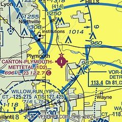
|
| Airport distance calculator |
|---|
|
|
| Sunrise and sunset |
|---|
|
Times for 30-Apr-2026
| | Local
(UTC-4) | | Zulu
(UTC) |
|---|
| Morning civil twilight | | 06:01 | | 10:01 |
| Sunrise | | 06:31 | | 10:31 |
| Sunset | | 20:31 | | 00:31 |
| Evening civil twilight | | 21:01 | | 01:01 |
|
| Current date and time |
|---|
| Zulu (UTC) | 30-Apr-2026 16:02:00 |
|---|
| Local (UTC-4) | 30-Apr-2026 12:02:00 |
|---|
|
| METAR |
|---|
KYIP
8nm SW | 301553Z 29012KT 10SM OVC045 09/00 A2997 RMK AO2 SLP150 T00940000
|
KDTW
9nm SE | 301553Z 30010KT 10SM BKN040 BKN080 10/00 A2997 RMK AO2 SLP150 T01000000
|
KARB
15nm SW | 734-668-7173
301553Z 31010KT 10SM BKN041 BKN050 09/00 A2997 RMK AO2 SLP151 T00940000
|
KVLL
17nm NE | 301555Z AUTO 31009G16KT 10SM SCT049 OVC075 10/M02 A2995 RMK AO2
|
KPTK
19nm N | 301553Z 30017G23KT 10SM BKN044 BKN070 BKN090 09/M02 A2996 RMK SLPNO T00901020
|
KDET
20nm E | 301553Z 32009G20KT 10SM FEW048 BKN100 11/M02 A2995 RMK AO2 SLP145 T01061017
|
|
| TAF |
|---|
KYIP
8nm SW | 301120Z 3012/0112 33007KT P6SM SCT030 BKN100 FM301700 30013KT P6SM BKN040 OVC120 FM010100 33007KT P6SM OVC040 FM010400 29004KT P6SM SCT050 OVC100
|
KDTW
9nm SE | 301120Z 3012/0118 33007KT P6SM SCT030 BKN100 FM301700 30013KT P6SM BKN040 OVC120 FM010100 33007KT P6SM OVC040 FM010400 29004KT P6SM SCT050 OVC100
|
KPTK
19nm N | 301120Z 3012/0112 33007KT P6SM SCT030 BKN100 FM301700 30013KT P6SM BKN040 OVC120 FM010100 33007KT P6SM SCT045 FM010400 35004KT P6SM SCT050 OVC100
|
KDET
20nm E | 301120Z 3012/0112 33007KT P6SM SCT030 BKN100 FM301700 30013KT P6SM BKN040 OVC120 FM010100 33007KT P6SM OVC040 FM010400 29004KT P6SM SCT050 OVC100
|
|
| NOTAMs |
|---|
NOTAMs are issued by the DoD/FAA and will open in a separate window not controlled by AirNav.
|
|

