FAA INFORMATION EFFECTIVE 27 NOVEMBER 2025
Location
| FAA Identifier: | YIP |
| Lat/Long: | 42-14-24.9860N 083-31-53.2600W
42-14.416433N 083-31.887667W
42.2402739,-83.5314611
(estimated) |
| Elevation: | 715.9 ft. / 218.2 m (surveyed) |
| Variation: | 06W (1995) |
| From city: | 24 miles SW of DETROIT, MI |
| Time zone: | UTC -5 (UTC -4 during Daylight Saving Time) |
| Zip code: | 48111 |
Airport Operations
| Airport use: | Open to the public |
| Activation date: | 12/1942 |
| Control tower: | yes |
| ARTCC: | CLEVELAND CENTER |
| FSS: | LANSING FLIGHT SERVICE STATION |
| NOTAMs facility: | YIP (NOTAM-D service available) |
| Attendance: | CONTINUOUS |
| Wind indicator: | lighted |
| Segmented circle: | no |
| Beacon: | white-green (lighted land airport)
Operates sunset to sunrise. |
| Landing fee: | yes, LANDING FEE IS BASED ON ACFT GWT. |
| Fire and rescue: | ARFF index A |
| Airline operations: | ARFF INDEX E SVC AVBL ON REQUEST CALL 734-485-6669. |
| International operations: | FOR CUSTOMS CLNC 1 HR MIN ADVANCE NOTIFICATION REQD.
PILOTS MUST CTC U.S. CUSTOMS ON 313-226-3140; RQ FOR
CUSTOMS SVC BY FAA FLIGHT PLAN IS NOT ACCEPTED. |
Airport Communications
| ATIS: | 127.425 |
| WX ASOS: | PHONE 734-961-6843 |
| WILLOW RUN GROUND: | 119.975 |
| WILLOW RUN TOWER: | 125.275 256.9 |
| DETROIT APPROACH: | 118.95 |
| DETROIT DEPARTURE: | 118.95 |
| METRO DP: | 118.95 ;WESTBOUND 134.3 ;EASTBOUND |
| WX ASOS at DTW (8 nm E): | PHONE 231-202-2054 |
| WX ASOS at ARB (10 nm W): | PHONE 734-668-7173 |
| WX AWOS-3 at ONZ (19 nm SE): | 119.675 (734-692-9686) |
| WX AWOS-3 at TTF (19 nm S): | 119.075 (734-384-0259) |
- EMERG FREQS NOT AVBL AT TWR.
Nearby radio navigation aids
| VOR radial/distance | | VOR name | | Freq | | Var |
|---|
| DXOr289/7.5 | | DETROIT VOR/DME | | 113.40 | | 06W |
| SVMr168/10.5 | | SALEM VORTAC | | 114.30 | | 03W |
| CRLr347/12.0 | | CARLETON VOR/DME | | 115.70 | | 03W |
| NDB name | | Hdg/Dist | | Freq | | Var | | ID |
|---|
| ADRIAN | | 054/32.9 | | 278 | | 06W | | ADG | .- -.. --. |
Airport Services
| Fuel available: | 100LL JET-A |
| Parking: | hangars and tiedowns |
| Airframe service: | MAJOR |
| Powerplant service: | MAJOR |
| Bottled oxygen: | HIGH |
| Bulk oxygen: | HIGH |
Runway Information
Runway 5/23
| Dimensions: | 7543 x 150 ft. / 2299 x 46 m |
| Surface: | concrete/grooved, in good condition |
| Weight bearing capacity: | | Single wheel: | 100.0 | | Double wheel: | 200.0 | | Double tandem: | 350.0 | | Dual double tandem: | 800.0 |
|
| Runway edge lights: | high intensity |
| RUNWAY 5 | | RUNWAY 23 |
| Latitude: | 42-13.837510N | | 42-14.688987N |
| Longitude: | 083-32.390983W | | 083-31.174575W |
| Elevation: | 714.3 ft. | | 701.5 ft. |
| Traffic pattern: | left | | left |
| Runway heading: | 053 magnetic, 047 true | | 233 magnetic, 227 true |
| Declared distances: | TORA:7543 TODA:7543 ASDA:7543 LDA:7543 | | TORA:7543 TODA:7543 ASDA:7543 LDA:7543 |
| Markings: | precision, in good condition | | precision, in good condition |
| Visual slope indicator: | 4-light PAPI on left (3.00 degrees glide path) | | 4-light PAPI on left (3.00 degrees glide path) |
| RVR equipment: | touchdown | | rollout |
| Approach lights: | MALSR: 1,400 foot medium intensity approach lighting system with runway alignment indicator lights | | MALSR: 1,400 foot medium intensity approach lighting system with runway alignment indicator lights |
| Runway end identifier lights: | no | | no |
| Centerline lights: | yes | | yes |
| Touchdown point: | yes, lighted | | yes, no lights |
| Instrument approach: | ILS/DME | | ILS/DME |
| Obstructions: | 74 ft. tree, 2434 ft. from runway, 817 ft. right of centerline, 30:1 slope to clear | | 39 ft. tree, 1387 ft. from runway, 674 ft. right of centerline, 29:1 slope to clear |
Runway 9/27
| Dimensions: | 5001 x 100 ft. / 1524 x 30 m |
| Surface: | asphalt/grooved, in excellent condition
ONLY THE 80' CENTER PORTION OF THE RY IS GRVD. |
| Weight bearing capacity: | | Single wheel: | 55.0 | | Double wheel: | 70.0 | | Double tandem: | 120.0 |
|
| Runway edge lights: | medium intensity |
| RUNWAY 9 | | RUNWAY 27 |
| Latitude: | 42-14.637053N | | 42-14.657772N |
| Longitude: | 083-32.599685W | | 083-31.491865W |
| Elevation: | 715.9 ft. | | 706.9 ft. |
| Traffic pattern: | left | | left |
| Runway heading: | 095 magnetic, 089 true | | 275 magnetic, 269 true |
| Declared distances: | TORA:5001 TODA:5001 ASDA:5001 LDA:5001 | | TORA:5001 TODA:5001 ASDA:5001 LDA:5001 |
| Markings: | nonprecision, in good condition | | nonprecision, in good condition |
| Visual slope indicator: | 4-light PAPI on left (3.00 degrees glide path) | | |
| Runway end identifier lights: | no | | no |
| Touchdown point: | yes, no lights | | yes, no lights |
Airport Ownership and Management from official FAA records
| Ownership: | Publicly-owned |
| Owner: | WAYNE COUNTY AIRPORT AUTHORITY
11050 ROGELL DR # 602
DETROIT, MI 48242-1144
Phone 734-485-6666 |
| Manager: | MICHAEL FAWAZ
47763 A ST
VAN BUREN TOWNSHIP, MI 48111-1271
Phone 734-485-6670 |
Additional Remarks
| A39-05/23 | PCR VALUE: 800/R/C/W/T |
| A39-09/27 | PCR VALUE: 350/F/C/X/T |
| A57-09 | RUNWAY 9 DISPLACED THRESHOLD OBSTRUCTION CLEARANCE 50:1 |
| - | BIRDS ON & INVOF ARPT. |
| - | CLSD TO SKEDD ACR OPS GTR THAN 9 PSGR SEATS. 72 HRS PPR FOR UNSKED ACR OPS WITH MORE THAN 30 PSGR SEATS CALL ARPT OPS MGR 734-485-6670. |
| - | LRA ARPT; ADCUS 734-942-9000. |
| - | CUST AVBL 24 HRS, MON - FRI AND ON CALL FROM DTW ON WKEND. |
| - | HELICOPTER TKOFS & LDGS ON THE SOUTH RAMP PROHIBITED, TAXI ONLY. |
| - | CONDS NOT MNT OUTSIDE M-F, 0800-1600,DTW AIRFIELD OPS (734-942-3685) PROVIDES DLY INSPECTIONS AND IS ON CALL FOR WX OR INCIDENTS OFF HRS. |
| - | WRONG SFC ARR RISK ARPT, CLOSELY ALIGNED PAVEMENT TXY G & RWY 09/27. |
Instrument Procedures
NOTE: All procedures below are presented as PDF files. If you need a reader for these files, you should download the free Adobe Reader.NOT FOR NAVIGATION. Please procure official charts for flight.
FAA instrument procedures published for use from 27 November 2025 at 0901Z to 25 December 2025 at 0900Z.
STARs - Standard Terminal Arrivals |
|---|
| FOREY TWO (RNAV) | |
download (159KB) |
| OKLND ONE (RNAV) | |
download (144KB) |
| PETTE TWO (RNAV) | |
download (210KB) |
| RRALF THREE (RNAV) | |
download (161KB) |
IAPs - Instrument Approach Procedures |
|---|
| ILS OR LOC RWY 05 **CHANGED** | |
download (224KB) |
| ILS OR LOC RWY 23 **CHANGED** | |
download (212KB) |
| RNAV (GPS) RWY 05 **CHANGED** | |
download (219KB) |
| RNAV (GPS) RWY 09 **CHANGED** | |
download (209KB) |
| RNAV (GPS) RWY 23 **CHANGED** | |
download (186KB) |
| VOR-A **CHANGED** | |
download (158KB) |
| NOTE: Special Alternate Minimums apply | |
download (139KB) |
Departure Procedures |
|---|
| BARII THREE (RNAV) | |
download (202KB) |
| CCOBB THREE (RNAV) | |
download (241KB) |
| CLVIN THREE (RNAV) | |
download (231KB) |
| HHOWE FOUR (RNAV) | |
download (235KB) |
| KAYLN THREE (RNAV) | |
download (205KB) |
| KZLOV TWO (RNAV) | |
download (196KB) |
| LIDDS FOUR (RNAV) | |
download (236KB) |
| METRO FOUR | |
2 pages:
[1] [2] (375KB) |
| MIGGY THREE (RNAV) | |
download (239KB) |
| PAVYL THREE (RNAV) | |
download (214KB) |
| SNDRS THREE (RNAV) | |
download (255KB) |
| TRMML FOUR (RNAV) | |
download (206KB) |
| ZETTR FOUR (RNAV) | |
download (250KB) |
| NOTE: Special Take-Off Minimums/Departure Procedures apply | |
download (346KB) |
Other nearby airports with instrument procedures:
1D2 - Canton-Plymouth-Mettetal Airport (7 nm NE)
KDTW - Detroit Metro Wayne County Airport (8 nm E)
KARB - Ann Arbor Municipal Airport (10 nm W)
Y47 - Oakland Southwest Airport (16 nm N)
KONZ - Grosse Ile Municipal Airport (19 nm SE)
KTTF - Custer Airport (19 nm S)
|
|

Road maps at:
MapQuest
Bing
Google
| Aerial photo |
|---|
WARNING: Photo may not be current or correct
 Photo by by Adam Reznik
Taken in September 2005
taken from a Cessna Cardinal, about 5000 MSL, with HP Photosmart 735
Photo by by Adam Reznik
Taken in September 2005
taken from a Cessna Cardinal, about 5000 MSL, with HP Photosmart 735
Do you have a better or more recent aerial photo of Willow Run Airport that you would like to share? If so, please send us your photo.
|
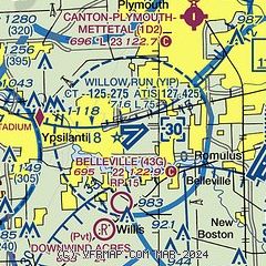
| Sectional chart |
|---|
|
CAUTION: Diagram may not be current
 Download PDF
of official airport diagram from the FAA
| Airport distance calculator |
|---|
|
|
| Sunrise and sunset |
|---|
|
Times for 09-Dec-2025
| | Local
(UTC-5) | | Zulu
(UTC) |
|---|
| Morning civil twilight | | 07:20 | | 12:20 |
| Sunrise | | 07:52 | | 12:52 |
| Sunset | | 17:01 | | 22:01 |
| Evening civil twilight | | 17:33 | | 22:33 |
|
| Current date and time |
|---|
| Zulu (UTC) | 09-Dec-2025 15:26:39 |
|---|
| Local (UTC-5) | 09-Dec-2025 10:26:39 |
|---|
|
| METAR |
|---|
| KYIP | 091508Z 17014KT 10SM BKN010 OVC046 M07/M08 A2984 RMK AO2 T10671083
|
KDTW
9nm E | 091510Z 18014KT 8SM FEW010 OVC050 M06/M08 A2986 RMK SNE10 T10561078
|
KARB
9nm W | 734-668-7173
091453Z 18010KT 6SM BR BKN008 OVC044 M06/M08 A2983 RMK AO2 SNE21 SLP116 P0000 60003 T10611083 58049
|
KONZ
19nm SE | 091515Z AUTO 19021G26KT 8SM -SN OVC007 M04/M05 A2985 RMK AO2 PK WND 20026/55 PRESFR
|
KTTF
19nm S | 091515Z AUTO 18013KT 10SM -SN OVC050 M05/M08 A2986 RMK AO2
|
|
| TAF |
|---|
| KYIP | 091313Z 0913/1012 19013KT 2SM -SN OVC025 TEMPO 0913/0914 3/4SM -SN BR OVC015 FM091600 22015G25KT 3SM -FZDZ BR OVC015 FM091900 24015G25KT 3SM BR OVC015 FM092200 22013KT 3SM BR OVC007 FM100400 24015G25KT 1SM -SN OVC007 TEMPO 1009/1012 3SM -RASN OVC015
|
KDTW
9nm E | 091359Z 0914/1018 18013KT 1/4SM SN FZFG OVC010 FM091415 19013KT 2SM -SN OVC025 FM091500 20015G25KT 3SM -FZDZ BR OVC015 FM091900 24015G25KT 3SM BR OVC015 FM092200 22013KT 3SM BR OVC007 FM100400 24015G25KT 1SM -SN OVC007 TEMPO 1009/1013 3SM -RASN OVC015 FM101300 26020G30KT 5SM -SHSN OVC015
|
|
| NOTAMs |
|---|
NOTAMs are issued by the DoD/FAA and will open in a separate window not controlled by AirNav.
|
|


