FAA INFORMATION EFFECTIVE 15 MAY 2025
Location
| FAA Identifier: | C62 |
| Lat/Long: | 41-28-21.7760N 085-15-38.8710W
41-28.362933N 085-15.647850W
41.4727156,-85.2607975
(estimated) |
| Elevation: | 1004.3 ft. / 306.1 m (surveyed) |
| Variation: | 04W (1995) |
| From city: | 2 miles N of KENDALLVILLE, IN |
| Time zone: | UTC -4 (UTC -5 during Standard Time) |
| Zip code: | 46755 |
Airport Operations
| Airport use: | Open to the public |
| Activation date: | 11/1946 |
| Control tower: | no |
| ARTCC: | CHICAGO CENTER |
| FSS: | TERRE HAUTE FLIGHT SERVICE STATION |
| NOTAMs facility: | HUF (NOTAM-D service available) |
| Attendance: | SUN 1200-1700, ALL MON - SAT 0800-1700
EMERG - 574-276-3933. |
| Wind indicator: | lighted |
| Segmented circle: | yes |
| Lights: | ACTVT REIL RWY 10 & 28; PAPI RWY 10 & 28; MIRL RWY 10/28 - CTAF. |
| Beacon: | white-green (lighted land airport)
Operates sunset to sunrise. |
Airport Communications
| CTAF/UNICOM: | 122.8 |
| WX AWOS-3P: | 119.925 (260-347-2967) |
| FORT WAYNE APPROACH: | 127.2 ;SW/NW OF ACTIVE RWY 132.15 ;SE/NE OF ACTIVE RWY |
| FORT WAYNE DEPARTURE: | 127.2 ;SW/NW OF ACTIVE RWY 132.15 ;SE/NE OF ACTIVE RWY |
| IC: | 127.2 ;SW/NW OF ACTIVE RWY |
| WX AWOS-3 at ANQ (13 nm NE): | 118.175 (260-668-5630) |
| WX AWOS-3P at GWB (13 nm SE): | 124.15 (260-925-8225) |
- APCH CTL SECTORIZATION BASED UPON FORT WAYNE RWY USAGE.
Nearby radio navigation aids
| VOR radial/distance | | VOR name | | Freq | | Var |
|---|
| OLKr041/(17.2) | | WEBSTER LAKE VOR | | 110.40 | | 03W |
| FWAr360/29.8 | | FORT WAYNE VORTAC | | 117.80 | | 06W |
| GSHr095/34.6 | | GOSHEN VORTAC | | 113.70 | | 00E |
| NDB name | | Hdg/Dist | | Freq | | Var | | ID |
|---|
| STURGIS | | 163/21.8 | | 382 | | 04W | | IRS | .. .-. ... |
Airport Services
| Fuel available: | 100LL JET-A |
| Parking: | hangars and tiedowns |
| Airframe service: | MINOR |
| Powerplant service: | MINOR |
Runway Information
Runway 10/28
| Dimensions: | 4400 x 75 ft. / 1341 x 23 m |
| Surface: | asphalt, in good condition |
| Weight bearing capacity: | |
| Runway edge lights: | medium intensity |
| Operational restrictions: | 160 FT CROPS N OF CNTRLN ENTIRE LEN. |
| RUNWAY 10 | | RUNWAY 28 |
| Latitude: | 41-28.373165N | | 41-28.352667N |
| Longitude: | 085-16.129303W | | 085-15.166412W |
| Elevation: | 999.7 ft. | | 1004.2 ft. |
| Traffic pattern: | left | | left |
| Runway heading: | 096 magnetic, 092 true | | 276 magnetic, 272 true |
| Markings: | nonprecision, in good condition | | nonprecision, in good condition |
| Visual slope indicator: | 2-light PAPI on left (3.50 degrees glide path) | | 2-light PAPI on left (3.50 degrees glide path)
UNUSBL BYD 9 DEGS RIGHT OF CNTRLN. |
| Runway end identifier lights: | yes | | yes |
| Touchdown point: | yes, no lights | | yes, no lights |
| Obstructions: | 40 ft. trees, 945 ft. from runway, 250 ft. left of centerline, 18:1 slope to clear | | 40 ft. trees, 990 ft. from runway, 140 ft. right of centerline, 19:1 slope to clear |
Airport Ownership and Management from official FAA records
| Ownership: | Publicly-owned |
| Owner: | KENDALLVILLE BOAC
363 E AIRPORT RD
KENDALLVILLE, IN 46755
Phone 260-349-0350 |
| Manager: | JOHN KLINE
363 E. AIRPORT RD.
KENDALLVILLE, IN 46755
Phone 260-349-0350 |
Additional Remarks
| A30A-10 | 5 FT TRRN DOWN SLOPE 100 FT FM RWY END. |
| - | GLIDER OPS MAY-NOV 0900-SS. |
| - | FOR CD CTC CHICAGO ARTCC AT 630-906-8921. |
Instrument Procedures
NOTE: All procedures below are presented as PDF files. If you need a reader for these files, you should download the free Adobe Reader.NOT FOR NAVIGATION. Please procure official charts for flight.
FAA instrument procedures published for use from 15 May 2025 at 0901Z to 13 June 2025 at 0900z.
IAPs - Instrument Approach Procedures |
|---|
| RNAV (GPS) RWY 10 | |
download (199KB) |
| RNAV (GPS) RWY 28 | |
download (227KB) |
| NOTE: Special Alternate Minimums apply | |
download (37KB) |
| NOTE: Special Take-Off Minimums/Departure Procedures apply | |
download (164KB) |
Other nearby airports with instrument procedures:
KANQ - Tri-State Steuben County Airport (13 nm NE)
KGWB - De Kalb County Airport (13 nm SE)
KSMD - Smith Field Airport (20 nm S)
KIRS - Kirsch Municipal Airport (22 nm N)
KGSH - Goshen Municipal Airport (24 nm W)
|
|

Road maps at:
MapQuest
Bing
Google
| Aerial photo |
|---|
WARNING: Photo may not be current or correct
 Photo by Jim Vandiver
Do you have a better or more recent aerial photo of Kendallville Municipal Airport that you would like to share? If so, please send us your photo.
|
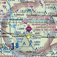
| Sectional chart |
|---|
|
| Airport distance calculator |
|---|
|
|
| Sunrise and sunset |
|---|
|
Times for 22-May-2025
| | Local
(UTC-4) | | Zulu
(UTC) |
|---|
| Morning civil twilight | | 05:44 | | 09:44 |
| Sunrise | | 06:17 | | 10:17 |
| Sunset | | 20:59 | | 00:59 |
| Evening civil twilight | | 21:31 | | 01:31 |
|
| Current date and time |
|---|
| Zulu (UTC) | 22-May-2025 23:40:36 |
|---|
| Local (UTC-4) | 22-May-2025 19:40:36 |
|---|
|
| METAR |
|---|
| KC62 | 222315Z AUTO 32007G18KT 290V350 10SM BKN041 11/02 A2994 RMK AO2 T01090024
|
KANQ
13nm NE | 222315Z AUTO 10SM BKN049 12/04 A2992 RMK AO2
|
KGWB
13nm SE | 222315Z AUTO 30013G19KT 10SM SCT044 12/03 A2992 RMK AO2
|
|
| TAF |
|---|
KFWA
30nm S | 221720Z 2218/2318 30013G21KT P6SM BKN035 FM230200 29008KT P6SM SCT100
|
|
| NOTAMs |
|---|
NOTAMs are issued by the DoD/FAA and will open in a separate window not controlled by AirNav.
|
|


