FAA INFORMATION EFFECTIVE 25 DECEMBER 2025
Location
| FAA Identifier: | 12N |
| Lat/Long: | 41-00-31.0310N 074-44-16.9220W
41-00.517183N 074-44.282033W
41.0086197,-74.7380339
(estimated) |
| Elevation: | 582.7 ft. / 178 m (estimated) |
| Variation: | 13W (2000) |
| From city: | 3 miles N of ANDOVER, NJ |
| Time zone: | UTC -5 (UTC -4 during Daylight Saving Time) |
| Zip code: | 07860 |
Airport Operations
| Airport use: | Open to the public |
| Control tower: | no |
| ARTCC: | NEW YORK CENTER |
| FSS: | MILLVILLE FLIGHT SERVICE STATION |
| NOTAMs facility: | 12N (NOTAM-D service available) |
| Attendance: | 0900-1700 |
| Wind indicator: | lighted |
| Segmented circle: | yes |
| Lights: | ACTVT MIRL RWY 03/21 - CTAF. |
| Beacon: | white-green (lighted land airport)
Operates sunset to sunrise. |
Airport Communications
| CTAF/UNICOM: | 122.8 |
| WX ASOS: | PHONE 609-325-2295 |
| NEWARK APPROACH: | 123.775 ;SFC TO 7000 FT |
| NEWARK DEPARTURE: | 123.775 ;SFC TO 7000 FT |
| WX ASOS at FWN (13 nm NE): | 118.525 (973-875-0859) |
| WX AWOS-3 at MMU (19 nm SE): | PHONE 973-290-0135 |
Nearby radio navigation aids
| VOR radial/distance | | VOR name | | Freq | | Var |
|---|
| STWr094/6.0 | | STILLWATER VOR/DME | | 109.60 | | 11W |
| SAXr260/9.7 | | SPARTA VORTAC | | 115.70 | | 11W |
| BWZr028/13.2 | | BROADWAY VOR/DME | | 114.20 | | 11W |
| HUOr206/25.0 | | HUGUENOT VOR/DME | | 116.10 | | 11W |
| SBJr010/25.5 | | SOLBERG VOR/DME | | 112.90 | | 10W |
| TEBr298/32.1 | | TETERBORO VOR/DME | | 108.40 | | 11W |
| FJCr073/36.7 | | ALLENTOWN VORTAC | | 117.50 | | 10W |
Airport Services
| Fuel available: | 100LL |
| Parking: | tiedowns |
| Airframe service: | MAJOR |
| Powerplant service: | MAJOR |
| Bottled oxygen: | NONE |
| Bulk oxygen: | NONE |
Runway Information
Runway 3/21
| Dimensions: | 1981 x 50 ft. / 604 x 15 m |
| Surface: | asphalt, in good condition |
| Runway edge lights: | medium intensity |
| RUNWAY 3 | | RUNWAY 21 |
| Latitude: | 41-00.365267N | | 41-00.669100N |
| Longitude: | 074-44.360467W | | 074-44.203600W |
| Elevation: | 582.4 ft. | | 582.5 ft. |
| Traffic pattern: | right | | left |
| Runway heading: | 034 magnetic, 021 true | | 214 magnetic, 201 true |
| Markings: | nonprecision, in good condition | | basic, in good condition |
| Touchdown point: | yes, no lights | | yes, no lights |
| Obstructions: | 108 ft. trees, 504 ft. from runway, 256 ft. left of centerline, 2:1 slope to clear
RWY 03 80 FT TREE AT RWY END 167 FT LEFT OF CNTRLN. | | 64 ft. tree, 580 ft. from runway, 150 ft. right of centerline, 5:1 slope to clear
RY 21 15 FT ROAD AT THLD. |
Helipad H1
| Dimensions: | 20 x 15 ft. / 6 x 5 m |
| Surface: | asphalt |
| Latitude: | 41-00.444540N | | |
| Longitude: | 074-44.355120W | | |
| Elevation: | 582.0 ft. | | |
| Traffic pattern: | left | | left |
Helipad H2
| Dimensions: | 20 x 15 ft. / 6 x 5 m |
| Surface: | asphalt |
| Latitude: | 41-00.459500N | | |
| Longitude: | 074-44.345667W | | |
| Elevation: | 582.0 ft. | | |
| Traffic pattern: | left | | left |
Airport Ownership and Management from official FAA records
| Ownership: | Publicly-owned |
| Owner: | NJ ST FOREST FIRE SVC
PO BOX 404
TRENTON, NJ 08625
Phone 609-292-2977 |
| Manager: | ERIC D. WEBER
AEROFLEX-ANDOVER ARPT, P.O. BOX 709
ANDOVER, NJ 07821
Phone 973-786-6350 |
Additional Remarks
| - | AVOID OVERFLYING LAKE LENAPE WHILE ON DOWNWIND. |
| - | FOR CD CTC NEWARK APCH AT 800-645-3206. |
| - | DEER & BIRDS ON & INVOF ARPT. |
| - | DIRT SVC ROAD TO TRML AREA IN FRONT OF RWY 03 THLD. |
| - | PARALLEL TURF RWY RESTRICTED USE ONLY. |
| - | ARPT RESTRICTED TO APCH CATAGORY A ACFT ONLY. |
| - | NO TGL. |
| - | RY 03/21 LAKES AT BOTH APCH ENDS. |
| - | NOISE ABATEMENT PROCEDURES IN EFFECT. CTC AMGR 973-786-5100. |
| - | PPR REQUIRED FOR NIGHT TRANSIENTS CTC AMGR 973-786-5100. |
Instrument Procedures
NOTE: All procedures below are presented as PDF files. If you need a reader for these files, you should download the free Adobe Reader.NOT FOR NAVIGATION. Please procure official charts for flight.
FAA instrument procedures published for use from 25 December 2025 at 0901z to 22 January 2026 at 0900z.
IAPs - Instrument Approach Procedures |
|---|
| RNAV (GPS) RWY 03 | |
download (198KB) |
| VOR-A | |
download (156KB) |
| NOTE: Special Alternate Minimums apply | |
download (143KB) |
| NOTE: Special Take-Off Minimums/Departure Procedures apply | |
download (440KB) |
Other nearby airports with instrument procedures:
1N7 - Blairstown Airport (12 nm W)
KFWN - Sussex Airport (13 nm NE)
4N1 - Greenwood Lake Airport (19 nm E)
KMMU - Morristown Municipal Airport (19 nm SE)
N07 - Lincoln Park Airport (20 nm E)
|
|

Road maps at:
MapQuest
Bing
Google
| Aerial photo |
|---|
WARNING: Photo may not be current or correct
 Photo by Joshua Weinstein
Photo taken 16-Oct-2018
looking southwest.
Photo by Joshua Weinstein
Photo taken 16-Oct-2018
looking southwest.
Do you have a better or more recent aerial photo of Aeroflex/Andover Airport that you would like to share? If so, please send us your photo.
|
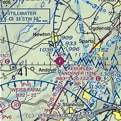
| Sectional chart |
|---|
|
| Airport distance calculator |
|---|
|
|
| Sunrise and sunset |
|---|
|
Times for 11-Jan-2026
| | Local
(UTC-5) | | Zulu
(UTC) |
|---|
| Morning civil twilight | | 06:54 | | 11:54 |
| Sunrise | | 07:24 | | 12:24 |
| Sunset | | 16:50 | | 21:50 |
| Evening civil twilight | | 17:20 | | 22:20 |
|
| Current date and time |
|---|
| Zulu (UTC) | 11-Jan-2026 05:44:18 |
|---|
| Local (UTC-5) | 11-Jan-2026 00:44:18 |
|---|
|
| METAR |
|---|
| K12N | 110454Z AUTO 00000KT 03/02 A2977 RMK AO1 SLP087 P0001 T00280017 400561006
|
KFWN
12nm N | 110500Z AUTO 00000KT 3SM HZ OVC010 04/01 A2977 RMK AO2 RAE0454 P0000 T00390011 $
|
KMMU
20nm SE | 110535Z AUTO 00000KT 3SM BR OVC007 04/04 A2976 RMK AO2
|
|
| TAF |
|---|
KTEB
32nm E | 110225Z 1102/1206 02007KT 2SM -RA BR BKN008 OVC015 FM110300 VRB04KT 2SM -DZ BR OVC004 FM111100 29007KT P6SM FEW009 BKN025 FM111400 29011G19KT P6SM SCT035 SCT100 FM111900 27016G25KT P6SM SCT040 FM112200 27018G28KT P6SM SCT040 PROB30 1122/1124 3SM -SHSN
|
KEWR
32nm SE | 110411Z 1104/1206 02010KT 2SM -RA BR BKN008 OVC015 FM110500 VRB05KT 1 1/2SM -DZ BR OVC003 FM111000 29009KT P6SM FEW009 BKN025 FM111400 28012G20KT P6SM SCT035 SCT100 FM111900 27016G25KT P6SM SCT040 FM112200 27020G32KT P6SM SCT040 PROB30 1122/1124 3SM -SHSN
|
KABE
39nm SW | 102002Z 1020/1118 08005KT 3SM -RA BR OVC015 FM102200 06007KT 2SM RA BR OVC005 FM110100 VRB02KT 1SM RA BR OVC003 FM110800 28008KT 3SM BR OVC008 FM111000 28010KT P6SM OVC015 FM111300 30010G18KT P6SM BKN080
|
|
| NOTAMs |
|---|
NOTAMs are issued by the DoD/FAA and will open in a separate window not controlled by AirNav.
|
|

