FAA INFORMATION EFFECTIVE 09 JULY 2026
Location
| FAA Identifier: | TEB |
| Lat/Long: | 40-51-00.3670N 074-03-39.0000W
40-51.006117N 074-03.650000W
40.8501019,-74.0608333
(estimated) |
| Elevation: | 8.3 ft. / 2.5 m (surveyed) |
| Variation: | 12W (1980) |
| From city: | 1 mile SW of TETERBORO, NJ |
| Time zone: | UTC -4 (UTC -5 during Standard Time) |
| Zip code: | 07608 |
Airport Operations
| Airport use: | Open to the public |
| Activation date: | 01/1947 |
| Control tower: | yes |
| ARTCC: | NEW YORK CENTER |
| FSS: | MILLVILLE FLIGHT SERVICE STATION |
| NOTAMs facility: | TEB (NOTAM-D service available) |
| Attendance: | CONTINUOUS |
| Pattern altitude: | TPA 1500 FT MSL FOR LARGE/TURBINE ACFT; 1000 FT MSL FOR ALL OTHERS. |
| Wind indicator: | lighted |
| Segmented circle: | no |
| Lights: | SS-SR |
| Beacon: | white-green (lighted land airport)
Operates sunset to sunrise. |
| Landing fee: | yes |
| Fire and rescue: | ARFF index A |
| Airline operations: | ARFF INDEX B EQUIPMENT COVERAGE PRVDD. |
| International operations: | customs landing rights airport |
Airport Communications
| WX ASOS: | PHONE 201-473-3130 |
| TETERBORO GROUND: | 121.9 |
| TETERBORO TOWER: | 119.5 125.1 |
| NEWARK APPROACH: | 127.6 |
| NEWARK DEPARTURE: | 119.2 126.7 |
| CLEARANCE DELIVERY: | 128.05 |
| D-ATIS: | 114.2 132.85 |
| EMERG: | 121.5 243.0 |
| JAIKE STAR: | 124.35 |
| MAZIE STAR: | 124.55 119.75 |
| OPS: | 130.575 |
| RAMP CTL: | 120.675 |
| VFR ADZY: | 119.5 |
| WILKES-BARRE STAR: | 127.6 |
| WX AWOS-3PT at JRB (9 nm S): | 128.175 (212-425-1534) |
| WX ASOS at LGA (10 nm SE): | PHONE 929-229-1994 |
| WX ASOS at CDW (10 nm W): | 135.5 (631-594-4523) |
| WX ASOS at EWR (11 nm SW): | PHONE 862-381-4743 |
| WX AWOS-3 at LDJ (16 nm SW): | 124.025 (908-862-7383) |
| WX AWOS-3 at MMU (16 nm W): | PHONE 973-290-0135 |
| WX ASOS at JFK (18 nm SE): | PHONE 347-588-1609 |
- ARPT OPS FREQUENCY 130.575.
- FOR RADAR SVC BLO 1800 FT CTC TEB ATCT FREQ 119.5.
- SAID IN USE. OPERATE TRANSPONDERS WITH ALTITUDE REPORTING MODE AND ADS-B (IF EQUIPPED) ENABLED ON ALL AIRPORT SURFACES.
Nearby radio navigation aids
| VOR radial/distance | | VOR name | | Freq | | Var |
|---|
| TEB at field | | TETERBORO VOR/DME | | 108.40 | | 11W |
| LGAr307/9.6 | | LA GUARDIA VOR/DME | | 113.10 | | 12W |
| CRIr343/16.1 | | CANARSIE VOR/DME | | 112.30 | | 11W |
| JFKr327/18.5 | | KENNEDY VOR/DME | | 115.90 | | 12W |
| SAXr132/25.3 | | SPARTA VORTAC | | 115.70 | | 11W |
| COLr019/32.6 | | COLTS NECK VOR/DME | | 115.40 | | 11W |
| CMKr232/33.7 | | CARMEL VOR/DME | | 116.60 | | 12W |
| DPKr288/34.6 | | DEER PARK VOR/DME | | 117.70 | | 12W |
| BWZr096/34.7 | | BROADWAY VOR/DME | | 114.20 | | 11W |
| SBJr073/34.9 | | SOLBERG VOR/DME | | 112.90 | | 10W |
| STWr114/37.7 | | STILLWATER VOR/DME | | 109.60 | | 11W |
Airport Services
| Fuel available: | 100LL JET-A |
| Parking: | hangars and tiedowns |
| Airframe service: | MAJOR |
| Powerplant service: | MAJOR |
| Bottled oxygen: | HIGH/LOW |
| Bulk oxygen: | HIGH/LOW |
Runway Information
Runway 1/19
| Dimensions: | 6997 x 150 ft. / 2133 x 46 m |
| Surface: | asphalt/grooved, in good condition |
| Weight bearing capacity: | | Single wheel: | 50.0 | | Double wheel: | 100.0 |
|
| Runway edge lights: | high intensity |
| RUNWAY 1 | | RUNWAY 19 |
| Latitude: | 40-50.320925N | | 40-51.471377N |
| Longitude: | 074-03.622230W | | 074-03.537385W |
| Elevation: | 8.3 ft. | | 6.3 ft. |
| Traffic pattern: | left | | left |
| Runway heading: | 015 magnetic, 003 true | | 195 magnetic, 183 true |
| Displaced threshold: | 770 ft. | | 767 ft. |
| Declared distances: | TORA:6997 TODA:6997 ASDA:6929 LDA:6159 | | TORA:6997 TODA:6997 ASDA:6997 LDA:6230 |
| Markings: | precision, in good condition | | precision, in good condition |
| Visual slope indicator: | 4-light PAPI on left (3.10 degrees glide path) | | 4-light PAPI on left (3.00 degrees glide path) |
| Runway end identifier lights: | yes | | yes |
| Centerline lights: | yes
RWY 01/19 DTHR CNTRLN LGTS OTS INDEFLY. | | yes |
| Touchdown point: | yes, no lights | | yes, lighted |
| Instrument approach: | | | ILS/DME |
| Obstructions: | 88 ft. tree, 802 ft. from runway, 524 ft. left of centerline, 7:1 slope to clear
RWY 01 67 FT TREE DIST 1200 FT, 400 FT RIGHT, 16:1 BASED ON DTHR. | | 263 ft. bldg, lighted, 9256 ft. from runway, 319 ft. left of centerline, 34:1 slope to clear
RWY 19 APCH RATIO 25:1 TO DTHR. |
Runway 6/24
| Dimensions: | 6014 x 150 ft. / 1833 x 46 m |
| Surface: | asphalt/grooved, in good condition |
| Weight bearing capacity: | | Single wheel: | 50.0 | | Double wheel: | 100.0 |
|
| Runway edge lights: | high intensity |
| RUNWAY 6 | | RUNWAY 24 |
| Latitude: | 40-50.803732N | | 40-51.464347N |
| Longitude: | 074-04.217537W | | 074-03.245737W |
| Elevation: | 4.8 ft. | | 6.7 ft. |
| Traffic pattern: | left | | left |
| Runway heading: | 060 magnetic, 048 true | | 240 magnetic, 228 true |
| Declared distances: | TORA:6014 TODA:6014 ASDA:6014 LDA:6014 | | TORA:6014 TODA:6014 ASDA:6014 LDA:6014 |
| Markings: | precision, in good condition | | precision, in good condition |
| Visual slope indicator: | | | 4-light PAPI on left (3.20 degrees glide path) |
| RVR equipment: | touchdown, rollout | | touchdown, rollout |
| Approach lights: | MALSR: 1,400 foot medium intensity approach lighting system with runway alignment indicator lights | | |
| Runway end identifier lights: | yes | | yes |
| Centerline lights: | yes | | yes |
| Touchdown point: | yes, lighted | | yes, no lights |
| Instrument approach: | ILS/DME | | |
| Obstructions: | 148 ft. tree, 5950 ft. from runway, 1293 ft. left of centerline, 38:1 slope to clear | | 77 ft. tree, 1705 ft. from runway, 462 ft. left of centerline, 19:1 slope to clear |
Airport Ownership and Management from official FAA records
| Ownership: | Publicly-owned |
| Owner: | PORT AUTHORITY OF NY & NJ
4 WORLD TRADE CENTER
NEW YORK, NY 10006
Phone 212-435-3640 |
| Manager: | SHERRI SMITH
90 MOONACHIE AVE
TETERBORO, NJ 07608
Phone 201-807-4019 |
Additional Remarks
| A39-06/24 | PCR VALUE: 343/F/D/X/T |
| A39-01/19 | PCR VALUE: 459/F/D/X/T |
| E60-24 | ENGINEERED MATERIALS ARRESTING SYSTEM (EMAS) 348 FT IN LENGTH BY 162 FT WIDTH LCTD AT DEP END RWY 24. |
| E60-19 | ENGINEERED MATERIALS ARRESTING SYSTEM (EMAS) 355 FT IN LENGTH BY 162 FT WIDTH LCTD AT DEP END RWY 19. |
| E60-06 | EMAS NON-STD ARRESTING GEAR/SYSTEM: ENGINEERED MATERIALS ARRESTING SYSTEM (EMAS) 250 FT IN LENGTH BY 170 FT WIDTH LCTD AT DEP END RWY 06. |
| - | CLSD TO MOTORLESS ACFT - UNCTLD ACFT & ULTRALIGHT ACTIVITY EXCEP BY PRIOR PERMISSION. |
| - | DLY CONS CONST ACT ALL QUADRANTS. |
| - | ACFT CAPABLE OF OPERATING ABV 100,000 POUNDS MUST SUBMIT CERTIFICATION TO AMGR VERIFYING AIRCRAFT OPERATING WEIGHT IS LESS THAN 100,000 LBS. CONTACT AIRPORT OPERATIONS AT 201-288-1775 FOR FORMS. |
| - | TEB RNAV (GPS) X RWY 06 IS PRIM RNAV APCH TO RWY 06. |
| - | ALL ACFT AVOID HOSPITAL 1.7 MILE NORTH OF RWY 01/19. |
| - | DEER AND BIRD ACT ON AND INVOF ARPT. |
| - | HEL OPNS OVER RESIDENTIAL AREAS BLO 1000 FT MSL SHOULD BE AVOIDED. |
| - | ACFT & HELICOPTER NOISE ABATEMENT RULES IN EFF; CTC ARPT NOISE ABATEMENT OFC 201-393-0399/288-1775 FOR COPY OF PROCEDURES & RULES PRIOR TO ARR. RY 24 NOISE CRITICAL RY MAX NOISE LIMIT OF 80 DB BETWEEN 2200-0700 & 90 DB ALL OTR HRS. |
| - | STAGE 1 ACFT NOT PERMITTED TO OPR AT TETERBORO ARPT. |
Instrument Procedures
NOTE: All procedures below are presented as PDF files. If you need a reader for these files, you should download the free Adobe Reader.NOT FOR NAVIGATION. Please procure official charts for flight.
FAA instrument procedures published for use from 09 July 2026 at 0901Z to 06 August 2026 at 0900Z.
STARs - Standard Terminal Arrivals |
|---|
| JAIKE FOUR (RNAV) **NEW** | |
2 pages:
[1] [2] (365KB) |
| MAZIE THREE (RNAV) **NEW** | |
download (199KB) |
| WILKES-BARRE FIVE **NEW** | |
download (182KB) |
IAPs - Instrument Approach Procedures |
|---|
| ILS OR LOC RWY 19 | |
download (245KB) |
| ILS Z OR LOC Z RWY 06 | |
download (311KB) |
| RNAV (RNP) Z RWY 06 | |
download (243KB) |
| RNAV (RNP) Z RWY 19 | |
download (236KB) |
| RNAV (GPS) RWY 01 | |
download (258KB) |
| RNAV (GPS) RWY 24 | |
download (227KB) |
| RNAV (GPS) X RWY 06 | |
download (280KB) |
| RNAV (GPS) X RWY 19 | |
download (245KB) |
| RNAV (GPS) Y RWY 06 | |
download (293KB) |
| RNAV (GPS) Y RWY 19 | |
download (240KB) |
| COPTER ILS Y OR LOC Y RWY 06 | |
download (198KB) |
| NOTE: Special Alternate Minimums apply | |
download (163KB) |
Departure Procedures |
|---|
| TETERBORO FOUR | |
2 pages:
[1] [2] (486KB) |
| WENTZ ONE (RNAV) | |
download (177KB) |
| NOTE: Special Take-Off Minimums/Departure Procedures apply | |
download (455KB) |
Other nearby airports with instrument procedures:
KJRA - West 30th St Heliport (6 nm SE)
6N5 - East 34th Street Heliport (8 nm SE)
KJRB - Downtown Manhattan/Wall Street Heliport (9 nm S)
KLGA - LaGuardia Airport (10 nm SE)
KCDW - Essex County Airport (10 nm W)
KEWR - Newark Liberty International Airport (11 nm SW)
N07 - Lincoln Park Airport (13 nm NW)
KLDJ - Linden Airport (16 nm SW)
KMMU - Morristown Municipal Airport (16 nm W)
KJFK - John F Kennedy International Airport (18 nm SE)
|
|

Road maps at:
MapQuest
Bing
Google
| Aerial photo |
|---|
WARNING: Photo may not be current or correct
 Photo by David Newcomer
Photo taken 17-Nov-2017
from 9,000' AGL looking northwest.
Photo by David Newcomer
Photo taken 17-Nov-2017
from 9,000' AGL looking northwest.
Do you have a better or more recent aerial photo of Teterboro Airport that you would like to share? If so, please send us your photo.
|
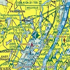
| Sectional chart |
|---|
|
CAUTION: Diagram may not be current
 Download PDF
of official airport diagram from the FAA
| Airport distance calculator |
|---|
|
|
| Sunrise and sunset |
|---|
|
Times for 25-Jul-2026
| | Local
(UTC-4) | | Zulu
(UTC) |
|---|
| Morning civil twilight | | 05:15 | | 09:15 |
| Sunrise | | 05:47 | | 09:47 |
| Sunset | | 20:18 | | 00:18 |
| Evening civil twilight | | 20:50 | | 00:50 |
|
| Current date and time |
|---|
| Zulu (UTC) | 25-Jul-2026 07:46:57 |
|---|
| Local (UTC-4) | 25-Jul-2026 03:46:57 |
|---|
|
| METAR |
|---|
| KTEB | 250651Z 00000KT 10SM CLR 19/14 A3015 RMK AO2 SLP208 T01890139 $
|
KNYC
6nm SE | 250651Z AUTO 00000KT 10SM CLR 20/13 A3018 RMK AO2 SLP210 T02000128 $
|
KLGA
9nm SE | 250651Z 07003KT 10SM FEW140 BKN250 21/16 A3015 RMK AO2 SLP209 T02110156 $
|
KJRB
9nm S | 250656Z AUTO 10003KT 10SM CLR 22/16 A3016 RMK AO2 SLP212 T02220161
|
KCDW
10nm W | 250653Z AUTO 00000KT 10SM CLR 16/14 A3016 RMK AO2 SLP218 T01610139
|
KEWR
11nm SW | 250651Z VRB03KT 10SM SCT140 BKN250 22/14 A3015 RMK AO2 SLP208 T02170144 $
|
KLDJ
16nm SW | 250735Z AUTO 00000KT 10SM CLR 20/14 A3014 RMK AO2 LTG DSNT SW T01950140
|
KMMU
17nm W | 250735Z AUTO 00000KT 10SM CLR 13/13 A3015 RMK AO2
|
KJFK
19nm SE | 250651Z 03003KT 10SM SCT140 BKN250 19/14 A3016 RMK AO2 SLP212 T01890139 $
|
|
| TAF |
|---|
| KTEB | 250523Z 2506/2612 VRB01KT P6SM FEW250 FM251300 05004KT P6SM SKC FM251500 10006KT P6SM SKC FM251800 12007KT P6SM FEW060 FM260000 16005KT P6SM SKC FM260200 VRB03KT P6SM SKC
|
KLGA
9nm SE | 250523Z 2506/2612 10005KT P6SM FEW250 FM250900 06005KT P6SM FEW250 FM251500 06012KT P6SM FEW060 FEW250 FM252000 12010KT P6SM FEW060 FEW250 FM260000 12007KT P6SM FEW250 FM260400 07005KT P6SM FEW250
|
KEWR
11nm SW | 250523Z 2506/2612 10004KT P6SM SCT250 FM250800 04005KT P6SM FEW250 FM251500 08007KT P6SM FEW250 FM251700 14009KT P6SM FEW060 FEW250 FM260000 12006KT P6SM FEW250 FM260400 07004KT P6SM FEW250
|
KJFK
19nm SE | 250523Z 2506/2612 09004KT P6SM SCT250 FM250900 05005KT P6SM FEW250 FM251500 13012KT P6SM FEW060 FEW250 FM260000 10008KT P6SM FEW250 FM260300 08005KT P6SM FEW250
|
|
| NOTAMs |
|---|
NOTAMs are issued by the DoD/FAA and will open in a separate window not controlled by AirNav.
|
|


