FAA INFORMATION EFFECTIVE 30 OCTOBER 2025
Location
| FAA Identifier: | 1F5 |
| Lat/Long: | 39-21-54.3000N 100-26-17.1000W
39-21.905000N 100-26.285000W
39.3650833,-100.4380833
(estimated) |
| Elevation: | 2733 ft. / 833.0 m (surveyed) |
| Variation: | 09E (1985) |
| Time zone: | UTC -6 (UTC -5 during Daylight Saving Time) |
| Zip code: | 67740 |
Airport Operations
| Airport use: | Open to the public |
| Activation date: | 01/1947 |
| Control tower: | no |
| ARTCC: | DENVER CENTER |
| FSS: | WICHITA FLIGHT SERVICE STATION |
| NOTAMs facility: | ICT (NOTAM-D service available) |
| Attendance: | UNATNDD |
| Wind indicator: | lighted |
| Segmented circle: | no |
| Lights: | ACTVT MIRL RWY 17/35 - CTAF. |
| Beacon: | white-green (lighted land airport) |
Airport Communications
Nearby radio navigation aids
| VOR radial/distance | | VOR name | | Freq | | Var |
|---|
| HLCr295/11.7 | | HILL CITY VORTAC | | 113.70 | | 08E |
| NDB name | | Hdg/Dist | | Freq | | Var | | ID |
|---|
| OBERLIN | | 165/28.2 | | 341 | | 06E | | OIN | --- .. -. |
Airport Services
| Parking: | tiedowns |
| Airframe service: | NONE |
| Powerplant service: | NONE |
Runway Information
Runway 17/35
| Dimensions: | 4400 x 50 ft. / 1341 x 15 m |
| Surface: | asphalt, in good condition |
| Runway edge lights: | medium intensity |
| RUNWAY 17 | | RUNWAY 35 |
| Traffic pattern: | left | | left |
| Markings: | basic, in good condition | | basic, in good condition |
| Obstructions: | 9 ft. sign, 201 ft. from runway, 89 ft. right of centerline
4 FT FENCE 0-160 FT DSTC, 108 R - 105 L. | | 15 ft. road, 201 ft. from runway, 125 ft. left and right of centerline
10 FT POST, 171 FT DSTC, 90 L, 10 FT SIGN, 158 FT DSTC, 135 FT L. 4 FT FENCE, 162 FT DSTC, 125 FT L/R. |
Runway 8/26
| Dimensions: | 1750 x 150 ft. / 533 x 46 m |
| Surface: | turf, in fair condition |
| Operational restrictions: | CLSD, NOT INSP. |
| RUNWAY 8 | | RUNWAY 26 |
| Latitude: | 39-21.903643N | | 39-21.906383N |
| Longitude: | 100-26.470202W | | 100-26.098758W |
| Elevation: | 2725.0 ft. | | 2700.0 ft. |
| Traffic pattern: | left | | left |
| Runway heading: | 080 magnetic, 089 true | | 260 magnetic, 269 true |
| Obstructions: | 17 ft. road, 180 ft. from runway, 10:1 slope to clear | | none |
Airport Ownership and Management from official FAA records
| Ownership: | Publicly-owned |
| Owner: | COUNTY CITY AIRPORT COMMISSION
829 MAIN ST, PO BOX 898
HOXIE, KS 67740
Phone 785-675-3291 |
| Manager: | WAYNE RANEY
829 MAIN ST, P O BOX 898
HOXIE, KS 67740
Phone 785-675-3988 |
Additional Remarks
| - | FOR CD CTC DENVER ARTCC AT 303-651-4257. |
Instrument Procedures
There are no published instrument procedures at 1F5.
Some nearby airports with instrument procedures:
1QK - Gove County Airport (22 nm SE)
KOEL - Oakley Municipal Airport (23 nm SW)
KHLC - Hill City Municipal Airport (28 nm E)
KCBK - Shalz Field Airport (28 nm W)
KOIN - Oberlin Municipal Airport (29 nm N)
|
|

Road maps at:
MapQuest
Bing
Google
| Aerial photo |
|---|
WARNING: Photo may not be current or correct
 Photo by Von Rothenberger and David Readio
Photo taken 23-Jul-2006
Photo by Von Rothenberger and David Readio
Photo taken 23-Jul-2006
Do you have a better or more recent aerial photo of Hoxie-Sheridan County Airport that you would like to share? If so, please send us your photo.
|
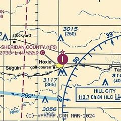
| Sectional chart |
|---|
|
| Airport distance calculator |
|---|
|
|
| Sunrise and sunset |
|---|
|
Times for 14-Nov-2025
| | Local
(UTC-6) | | Zulu
(UTC) |
|---|
| Morning civil twilight | | 06:57 | | 12:57 |
| Sunrise | | 07:25 | | 13:25 |
| Sunset | | 17:27 | | 23:27 |
| Evening civil twilight | | 17:56 | | 23:56 |
|
| Current date and time |
|---|
| Zulu (UTC) | 14-Nov-2025 12:43:11 |
|---|
| Local (UTC-6) | 14-Nov-2025 06:43:11 |
|---|
|
| METAR |
|---|
KOEL
23nm SW | 141215Z AUTO 28010KT 10SM CLR 08/M01 A2994 RMK AO1 T00801012
|
KHLC
28nm E | 141153Z AUTO 00000KT 10SM CLR 02/M01 A2992 RMK AO2 SLP133 T00221006 10056 20017 56001
|
KOIN
28nm N | 141215Z AUTO 26003KT 10SM CLR 03/00 A2992 RMK AO2
|
KCBK
29nm W | 141215Z AUTO 26008KT 10SM CLR 06/M01 A2995 RMK AO2 T00551007
|
KNRN
38nm NE | 141215Z AUTO 25004KT 10SM CLR 02/M01 A2991 RMK AO2
|
|
| NOTAMs |
|---|
NOTAMs are issued by the DoD/FAA and will open in a separate window not controlled by AirNav.
|
|


