FAA INFORMATION EFFECTIVE 16 APRIL 2026
Location
| FAA Identifier: | 1RL |
| Lat/Long: | 48-58-37.7000N 123-04-45.2000W
48-58.628333N 123-04.753333W
48.9771389,-123.0792222
(estimated) |
| Elevation: | 11 ft. / 3 m |
| Variation: | 19E (2000) |
| From city: | 1 mile SW of POINT ROBERTS, WA |
| Time zone: | UTC -7 (UTC -8 during Standard Time) |
| Zip code: | 98281 |
Airport Operations
| Airport use: | Open to the public |
| Activation date: | 10/2002 |
| Control tower: | no |
| ARTCC: | SEATTLE CENTER |
| FSS: | SEATTLE FLIGHT SERVICE STATION |
| NOTAMs facility: | SEA (NOTAM-D service available) |
| Attendance: | MON-FRI 0900-1700 |
| Wind indicator: | yes |
| Segmented circle: | no |
| Landing fee: | yes, PRKG AVBL ON GRASS AREA, NO TIE DOWNS PRVD. THERE IS A $10 LNDG FEE FOR VISITING ACFT. TSNT ACFT FOR OVNGT TIE DOWNS IS $15 PER NIGHT. PAYMENT DROP BOX IS INSIDE HNGR ON EAST WALL. YOU MUST TEXT FOR PMSN FIRST, SO THAT THE NR OF PLANES CAN BE CONTROLLED ON THE FLD. PHONE NR: 778-846-4311. |
Airport Communications
| CTAF/UNICOM: | 122.8 |
| WX AWOS-3P at ORS (17 nm S): | 135.425 (360-376-6045) |
Nearby radio navigation aids
| VOR radial/distance | | VOR name | | Freq | | Var |
|---|
| YVRr138/6.6 | | VANCOUVER VOR/DME | | 115.90 | | 17E |
| YYJr030/21.9 | | VICTORIA VOR/DME | | 113.70 | | 17E |
| NDB name | | Hdg/Dist | | Freq | | Var | | ID |
|---|
| FRIDAY HARBOR | | 339/28.0 | | 284 | | 17E | | FHR | ..-. .... .-. |
| NANAIMO | | 085/32.4 | | 251 | | 21E | | YCD | -.-- -.-. -.. |
Airport Services
Runway Information
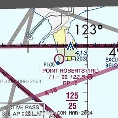
Runway 16/34
| Dimensions: | 2265 x 125 ft. / 690 x 38 m |
| Surface: | turf, in good condition |
| RUNWAY 16 | | RUNWAY 34 |
| Latitude: | 48-58.814438N | | 48-58.441875N |
| Longitude: | 123-04.755407W | | 123-04.752807W |
| Elevation: | 11.0 ft. | | 8.0 ft. |
| Traffic pattern: | right | | left |
| Runway heading: | 161 magnetic, 180 true | | 341 magnetic, 360 true |
| Obstructions: | 120 ft. trees, 752 ft. from runway, 6:1 slope to clear | | 28 ft. trees, 203 ft. from runway, 8:1 slope to clear |
Airport Ownership and Management from official FAA records
| Ownership: | Privately-owned |
| Owner: | LILY POINT HOLDINGS LLC
622 MARINE DRIVE
POINT ROBERTS, WA 98281
Phone (778) 846-4311 |
| Manager: | BOB GRANLEY
693 HIGHLAND DRIVE
POINT ROBERTS, WA 98281
Phone (778) 846-4311 |
Additional Remarks
| - | TRAFFIC PATTERN WEST OF FLD OVER WATER. |
| - | NOISE ABATEMENT PROC IN EFCT, CTC AMGR FOR DTLS AT 778-846-4311. |
| - | WHEN ABLE LAND TO THE 'N' AND DEPART TO THE 'S'. |
| - | BOUNDARY BAY (CZBB) ATIS AVBL, 125.5 OR 1-877-517-2847, BOUNDARY BAY TWR 118.1 OR 127.6. |
| - | TKO TO THE SOUTH, 15 DEGREES RIGHT TURN FOR NOISE ABATEMENT |
| - | TKO TO THE NORTH, TURN 30 DEGREES WEST AS SOON AS POSSIBLE |
| - | FOR CD CTC VANCOUVER TRML AT 604-586-4571. |
| - | THERE IS NO CAMPING ON THE PROPERTY. |
Instrument Procedures
There are no published instrument procedures at 1RL.
Some nearby airports with instrument procedures:
KORS - Orcas Island Airport (17 nm S)
KBLI - Bellingham International Airport (24 nm SE)
KFHR - Friday Harbor Airport (27 nm S)
KBVS - Skagit Regional Airport (40 nm SE)
KNUW - Whidbey Island Naval Air Station (Ault Field) Airport (41 nm SE)
|
|

Road maps at:
MapQuest
Bing
Google
| Aerial photo |
|---|
WARNING: Photo may not be current or correct
 Photo by Dennis C Whitehead
Taken in August 2019
looking north toward Vancouver BC.
Photo by Dennis C Whitehead
Taken in August 2019
looking north toward Vancouver BC.
Do you have a better or more recent aerial photo of Point Roberts Airpark that you would like to share? If so, please send us your photo.
|
| Sectional chart |
|---|
|
| Airport distance calculator |
|---|
|
|
| Sunrise and sunset |
|---|
|
Times for 22-Apr-2026
| | Local
(UTC-7) | | Zulu
(UTC) |
|---|
| Morning civil twilight | | 05:34 | | 12:34 |
| Sunrise | | 06:08 | | 13:08 |
| Sunset | | 20:13 | | 03:13 |
| Evening civil twilight | | 20:48 | | 03:48 |
|
| Current date and time |
|---|
| Zulu (UTC) | 23-Apr-2026 01:53:36 |
|---|
| Local (UTC-7) | 22-Apr-2026 18:53:36 |
|---|
|
| METAR |
|---|
CWVF
11nm NW | 230100Z AUTO 15015KT 12/09 RMK AO1 PK WND 16017/0013 T01240088
|
CWWK
13nm E | 230100Z AUTO 17003KT 15/08 RMK AO1 SLP158 T01480076 53010
|
CWEZ
13nm S | 230100Z AUTO 20006KT 12/09 RMK AO1 SLP156 T01150087 53005
|
CYVR
14nm N | 230100Z 16007G15KT 30SM FEW050 SCT230 15/08 A2998 RMK SC2CI2 SLP153
|
KORS
18nm SE | 230135Z AUTO 17010KT 10SM CLR 14/09 A3000 RMK AO2
|
CWMM
21nm NE | 230100Z AUTO 20004KT 15/06 RMK AO1 SLP157 T01450055 53012
|
|
| TAF |
|---|
CYVR
14nm N | 222040Z 2221/2324 29010G20KT P6SM FEW040 BKN070 TEMPO 2221/2224 SCT070 BECMG 2222/2224 26008KT FM230000 26008KT P6SM SKC BECMG 2302/2304 11005KT FM231200 07008KT P6SM SCT015 TEMPO 2312/2321 BKN015 BECMG 2316/2318 25008KT RMK NXT FCST BY 230000Z
|
|
| NOTAMs |
|---|
NOTAMs are issued by the DoD/FAA and will open in a separate window not controlled by AirNav.
|
|

