FAA INFORMATION EFFECTIVE 09 JULY 2026
Location
| FAA Identifier: | NUW |
| Lat/Long: | 48-21-06.6250N 122-39-21.4530W
48-21.110417N 122-39.357550W
48.3518403,-122.6559592
(estimated) |
| Elevation: | 47.4 ft. / 14.4 m (surveyed) |
| Variation: | 18E (2005) |
| From city: | 3 miles N of OAK HARBOR, WA |
| Time zone: | UTC -7 (UTC -8 during Standard Time) |
| Zip code: | 98277 |
Airport Operations
| Airport use: | Private use. Permission required prior to landing |
| Activation date: | 01/1950 |
| Control tower: | yes |
| ARTCC: | SEATTLE CENTER |
| FSS: | SEATTLE FLIGHT SERVICE STATION |
| NOTAMs facility: | NUW (NOTAM-D service available) |
| Attendance: | CONTINUOUS |
| Segmented circle: | no |
| Lights: | AVBL ONLY DURING HRS OF OPERATION. |
| Beacon: | white-white-green (lighted military airport)
Operates sunset to sunrise. |
Airport Communications
| ATIS: | 134.15 281.5 |
| WX ASOS: | PHONE 360-257-8813 |
| WHIDBEY GROUND: | 121.75 336.4 |
| WHIDBEY TOWER: | 127.9 340.2 |
| WHIDBEY APPROACH: | 118.2 ;WEST 120.7 ;EAST 270.8 ;EAST 285.65 ;WEST |
| WHIDBEY DEPARTURE: | 118.2 ;WEST 120.7 ;EAST 270.8 ;EAST 285.65 ;WEST |
| CLEARANCE DELIVERY: | 135.1 135.1 379.9 |
| PRE-TAXI CLEARANCE: | 135.1 |
| CLASS C: | 118.2 ;WEST 120.7 ;EAST 270.8 ;EAST 285.65 ;WEST |
| EMERG: | 121.5 243.0 |
| IC: | 118.2 ;WEST 120.7 ;EAST 270.8 ;EAST |
| PMSV METRO: | 343.4 |
| PTD: | 350.1 |
| WX AWOS-3 at OKH (6 nm S): | 132.775 (360-675-8431) |
| WX AWOS-3 at BVS (12 nm NE): | 121.125 (360-757-7767) |
| WX AWOS-3P at S31 (14 nm NW): | 118.525 (360-376-2071) |
| WX ASOS at FHR (18 nm NW): | 135.675 (360-378-8491) |
| WX AWOS-3P at 0S9 (19 nm S): | 119.025 (360-379-1199) |
Nearby radio navigation aids
| VOR radial/distance | | VOR name | | Freq | | Var |
|---|
| CVVr004/7.0 | | PENN COVE VOR/DME | | 117.20 | | 19E |
| PAEr310/30.0 | | PAINE VOR/DME | | 110.60 | | 20E |
| YYJr107/39.9 | | VICTORIA VOR/DME | | 113.70 | | 17E |
| NDB name | | Hdg/Dist | | Freq | | Var | | ID |
|---|
| FRIDAY HARBOR | | 106/17.5 | | 284 | | 17E | | FHR | ..-. .... .-. |
Airport Services
| Fuel available: | 100LL J5 J8 |
| Bottled oxygen: | NONE |
| Bulk oxygen: | HIGH/LOW |
Runway Information
Runway 14/32
| Dimensions: | 8001 x 200 ft. / 2439 x 61 m
RWY 14/32 PORTION OF SE END BTN 3000 & 2000 FT REMAINING MKR NOT FULLY VISIBLE FM ATCT. |
| Surface: | concrete, in good condition |
| Weight bearing capacity: | |
| Runway edge lights: | high intensity |
| RUNWAY 14 | | RUNWAY 32 |
| Latitude: | 48-21.702207N | | 48-20.513117N |
| Longitude: | 122-39.750527W | | 122-38.905135W |
| Elevation: | 39.3 ft. | | 47.4 ft. |
| Traffic pattern: | left | | left |
| Runway heading: | 137 magnetic, 155 true | | 317 magnetic, 335 true |
| Markings: | precision, in good condition | | precision, in good condition |
| Visual slope indicator: | 4-light PAPI on left (3.00 degrees glide path) | | 4-light PAPI on left (3.00 degrees glide path) |
| Approach lights: | ALSF2: standard 2,400 foot high intensity approach lighting system with centerline sequenced flashers (category II or III) | | ALSF2: standard 2,400 foot high intensity approach lighting system with centerline sequenced flashers (category II or III) |
| Centerline lights: | yes | | yes |
| Touchdown point: | yes, lighted | | yes, no lights |
| Instrument approach: | ILS/DME | | |
Runway 7/25
| Dimensions: | 7999 x 200 ft. / 2438 x 61 m |
| Surface: | concrete, in good condition |
| Weight bearing capacity: | |
| Runway edge lights: | high intensity |
| RUNWAY 7 | | RUNWAY 25 |
| Latitude: | 48-21.078325N | | 48-21.147848N |
| Longitude: | 122-40.372823W | | 122-38.401837W |
| Elevation: | 18.4 ft. | | 23.9 ft. |
| Traffic pattern: | left | | left |
| Runway heading: | 069 magnetic, 087 true | | 249 magnetic, 267 true |
| Markings: | precision, in good condition | | precision, in good condition |
| Visual slope indicator: | 4-light PAPI on left (3.00 degrees glide path) | | 4-light PAPI on left (3.00 degrees glide path) |
| Approach lights: | | | ALSF1: standard 2,400 foot high intensity approach lighting system with centerline sequenced flashers (category I) |
| Runway end identifier lights: | no | | |
| Touchdown point: | yes, no lights | | yes, no lights |
Airport Ownership and Management from official FAA records
| Ownership: | U.S. Navy |
| Owner: | U S NAVY
OCEANOGRAPHIC OFC CODE 3142
WASHINGTON, D C 20373 |
| Manager: | COMMANDING OFFICER
NAS WHIDBEY ISLAND
OAK HARBOR, WA 98278
Phone 360 257 2681 |
Additional Remarks
| - | SEE FLIP AP/1. |
| - | CSTMS/AG/IMG: 48 HR PN REQ, CTC AIR TERMINAL SUPERVISOR, 1430-0100Z++ AT DSN 820-2604/6707, C360-257-2604/6707. |
| - | SERVICE- JASU - 1 (NC-10C), 1 (GTC-85/GTE-85), 1(MSU-200NAV/ A/U47A-5 FUEL-J8 FLUID-SP PRESAIR DE-ICE (2 HR PN REQ) LHOX TRAN ALERT- TRAN CREWS MUST PROVIDE TECHNICAL DIRECT/ASSISTANCE IN SVC/MAINT TO INCLUDE DIRECT SUPERVISION OF FUELING. LTD SVC/MAINT AVBL 1500-2300Z++ MON-FRI. NO MAINT SAT, SUNAND HOL. AIR TERMINAL OPR 1400-0200Z++, AS RQR OT. |
| - | OLS LENSES AVBL TO ALL RWY. |
| - | HIRL AND SFL UNAVBL TO RWY 7. RCLL AVBL TO RWY 14-32 ONLY. |
| - | OPERATIONS DUTY OFFICER C360-257-2681, DSN 820-2681. |
| - | FOR CIVIL AIRCRAFT LANDING PERMITS (CALP) REQUESTS CTC OPS DUTY OFFICER. |
| - | CTN: LANDING SIGNAL OFFICER SHELTER 15 FT AGL, 32 FT FROM RWY EDGE, LCTD LEFT SIDE RWY, 558 FT FROM RWY 07 THLD AND 400 FT FROM THLD ON RWY 14, 25 AND 32. LARGE ACFT EXER CTN. EXTREME CTN RQRD FOR BACK TAXI IN LAST 1000 FT OF ALL RWYS. |
| - | CTN: NO WEPS LOADING OR OFFLOADING BTN HN. |
| - | DCT REFUL FAC LANES NOT AVBL TO TRAN ACFT. |
| - | SERVICE - PAPI RWY 07/25 AND RWY 14/32 H24. |
| - | RSTD: PPR REQUIRED FOR ALL ACFT EXC SAR/MEDEVAC. CTC AIR TERMINAL SUPERVISOR, 1430-0100Z++ AT DSN 820-2604/6707, C360-257-2604/6707. PRIOR COORD/FLT ADVSY RQR FOR AMC/JOSAC/NALO MSN. |
| - | TFC PAT - OVERHEAD INITIAL FOR RWYS 7, 14, 32 4NM 2500', RWY 25 6NM 3000'; OVERHEAD BREAK 1500'; PATTERN ALT 1000'. |
Instrument Procedures
NOTE: All procedures below are presented as PDF files. If you need a reader for these files, you should download the free Adobe Reader.NOT FOR NAVIGATION. Please procure official charts for flight.
FAA instrument procedures published for use from 09 July 2026 at 0901Z to 06 August 2026 at 0900Z.
IAPs - Instrument Approach Procedures |
|---|
| ILS OR LOC/DME RWY 14 | |
download (153KB) |
| RNAV (GPS) RWY 07 | |
download (82KB) |
| RNAV (GPS) RWY 14 | |
download (94KB) |
| RNAV (GPS) RWY 25 | |
download (90KB) |
| RNAV (GPS) RWY 32 | |
download (85KB) |
| HI-TACAN Z RWY 07 | |
download (369KB) |
| HI-TACAN Z RWY 14 | |
download (371KB) |
| HI-TACAN Z RWY 25 | |
download (289KB) |
| HI-TACAN Z RWY 32 | |
download (290KB) |
| TACAN Y RWY 07 | |
download (136KB) |
| TACAN Y RWY 14 | |
download (142KB) |
| TACAN Y RWY 25 | |
download (140KB) |
| TACAN Y RWY 32 | |
download (142KB) |
| Radar Approach Procedures available | |
download (149KB) |
|
|---|
| NASWI THREE (OBSTACLE) | |
download (102KB) |
| NOTE: Special Take-Off Minimums/Departure Procedures apply | |
download (559KB) |
Other nearby airports with instrument procedures:
KOKH - DeLaurentis Airport (6 nm S)
KBVS - Skagit Regional Airport (12 nm NE)
KFHR - Friday Harbor Airport (18 nm NW)
0S9 - Jefferson County International Airport (19 nm S)
KAWO - Arlington Municipal Airport (23 nm SE)
|
|

Road maps at:
MapQuest
Bing
Google
| Aerial photo |
|---|
WARNING: Photo may not be current or correct
 Photo by Trent Thomas
Photo taken 21-Sep-2021
3,500 AGL facing NE
Photo by Trent Thomas
Photo taken 21-Sep-2021
3,500 AGL facing NE
Do you have a better or more recent aerial photo of Whidbey Island Naval Air Station (Ault Field) Airport that you would like to share? If so, please send us your photo.
|
| Sectional chart |
|---|
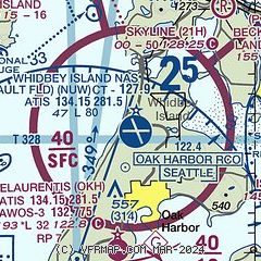
|
 Download PDF
of official airport diagram from the FAA
| Airport distance calculator |
|---|
|
|
| Sunrise and sunset |
|---|
|
Times for 28-Jul-2026
| | Local
(UTC-7) | | Zulu
(UTC) |
|---|
| Morning civil twilight | | 05:04 | | 12:04 |
| Sunrise | | 05:42 | | 12:42 |
| Sunset | | 20:53 | | 03:53 |
| Evening civil twilight | | 21:30 | | 04:30 |
|
| Current date and time |
|---|
| Zulu (UTC) | 28-Jul-2026 09:54:51 |
|---|
| Local (UTC-7) | 28-Jul-2026 02:54:51 |
|---|
|
| METAR |
|---|
| KNUW | 280853Z 12003KT 10SM FEW035 FEW070 14/13 A2998 RMK AO2 SLP156 T01390128 58004 $
|
KOKH
6nm S | 280933Z AUTO 00000KT 10SM CLR 12/12 A2999 RMK AO2
|
KNRA
10nm S | 280846Z AUTO 17003KT 10SM SCT050 13/13 A2999 RMK AO2 SLP099 6//// T01330128 58005 TSNO PNO $
|
KBVS
12nm NE | 280935Z AUTO 00000KT 10SM BKN055 OVC065 15/15 A2998 RMK A01
|
KFHR
18nm NW | 280853Z AUTO 00000KT 10SM SCT100 12/11 A2998 RMK AO2 SLP151 T01170111 58004
|
K0S9
19nm S | 280935Z AUTO 00000KT 10SM OVC027 13/13 A2997 RMK AO2
|
|
| TAF |
|---|
| KNUW | 280700Z 2807/2907 VRB06KT 9999 VCSH FEW040 FEW090 QNH2995INS FM280900 VRB06KT 9999 VCSH FEW010 BKN020 BKN090 QNH2996INS BECMG 2812/2814 15015G25KT 9999 VCSH SCT010 BKN020 BKN030 QNH2999INS TEMPO 2814/2819 15018G30KT 9000 -SHRA FEW010 BKN040 OVC100 FM282200 VRB06KT 9999 FEW010 BKN030 BKN090 QNH3002INS FM290400 26010KT 9999 FEW010 BKN040 QNH3003INS TX20/2823Z TN12/2812Z FS30232
|
|
| NOTAMs |
|---|
NOTAMs are issued by the DoD/FAA and will open in a separate window not controlled by AirNav.
|
|


