FAA INFORMATION EFFECTIVE 25 DECEMBER 2025
Location
| FAA Identifier: | OKH |
| Lat/Long: | 48-15-05.5000N 122-40-25.2000W
48-15.091667N 122-40.420000W
48.2515278,-122.6736667
(estimated) |
| Elevation: | 193.3 ft. / 58.9 m (surveyed) |
| Variation: | 19E (2000) |
| From city: | 3 miles SW of OAK HARBOR, WA |
| Time zone: | UTC -8 (UTC -7 during Daylight Saving Time) |
| Zip code: | 98277 |
Airport Operations
| Airport use: | Open to the public |
| Activation date: | 09/1964 |
| Control tower: | no |
| ARTCC: | SEATTLE CENTER |
| FSS: | SEATTLE FLIGHT SERVICE STATION |
| NOTAMs facility: | OKH (NOTAM-D service available) |
| Attendance: | UNATTENDED |
| Wind indicator: | yes |
| Segmented circle: | yes |
| Lights: | ACTVT NSTD LIRL RWY 07/25 - CTAF. |
| Beacon: | white-green (lighted land airport)
Operates sunset to sunrise. |
| Landing fee: | yes |
| International operations: | customs landing rights airport |
Airport Communications
| CTAF/UNICOM: | 122.8 |
| WX AWOS-3: | 132.775 (360-675-8431) |
| WHIDBEY APPROACH: | 118.2 [0600-2200] |
| WHIDBEY DEPARTURE: | 118.2 [0600-2200] |
| WX ASOS at NUW (6 nm N): | PHONE 360-257-8813 |
| WX AWOS-3P at 0S9 (13 nm SW): | 119.025 (360-379-1199) |
| WX AWOS-3 at BVS (17 nm NE): | 121.125 (360-757-7767) |
| WX AWOS-3P at S31 (17 nm NW): | 118.525 (360-376-2071) |
Nearby radio navigation aids
| VOR radial/distance | | VOR name | | Freq | | Var |
|---|
| CVVr060/2.1 | | PENN COVE VOR/DME | | 117.20 | | 19E |
| PAEr301/25.5 | | PAINE VOR/DME | | 110.60 | | 20E |
Airport Services
| Parking: | tiedowns |
| Airframe service: | NONE |
| Powerplant service: | NONE |
| Bottled oxygen: | NONE |
| Bulk oxygen: | NONE |
Runway Information
Runway 7/25
| Dimensions: | 3265 x 60 ft. / 995 x 18 m |
| Surface: | asphalt, in excellent condition |
| Weight bearing capacity: | |
| Runway edge lights: | low intensity
NSTD LIRL ONLY W 2604 FT FM RY LIGHTS. |
| Runway edge markings: | MARKINGS ARE FADED. |
| RUNWAY 7 | | RUNWAY 25 |
| Latitude: | 48-15.092622N | | 48-15.090225N |
| Longitude: | 122-40.822432W | | 122-40.018443W |
| Elevation: | 141.0 ft. | | 193.3 ft. |
| Traffic pattern: | right | | left |
| Runway heading: | 071 magnetic, 090 true | | 251 magnetic, 270 true |
| Displaced threshold: | 507 ft. | | no |
| Markings: | basic, in poor condition | | basic, in fair condition |
| Visual slope indicator: | 2-light PAPI on left | | |
| Touchdown point: | yes, no lights | | yes, no lights |
| Obstructions: | 22 ft. fence, 530 ft. from runway, 15:1 slope to clear
ROAD AT 32 FT; 8 FT BRUSH & FENCE AT 85 FT. | | 90 ft. tree, 1287 ft. from runway, 105 ft. left of centerline, 12:1 slope to clear
5' FENCE 29' FM THR 125 L & R. |
Airport Ownership and Management from official FAA records
| Ownership: | Privately-owned |
| Owner: | DFF LLC
PO BOX 3351
SAN DIEGO, CA 92163
Phone 619-368-9410 |
| Manager: | ROBERT DELAURENTIS
1140 MONROE LANDING ROAD
OAK HARBOR, WA 98277
Phone 619-368-9410 |
Additional Remarks
| - | TREES, BRUSH, SIGN & PARKED ACFT IN PRIM SFC. |
| - | PPR FOR ULTRALIGHTS AND GLIDERS CTC AMGR PHONE 619-368-9410. |
| - | DEER NEAR ALL MOVEMENT AREAS. |
| - | WHIDBEY ISLAND NAS (AULT FLD) ATIS AVBL ON FREQ 134.15/281.5. |
| - | AWOS-3 FREQ 132.775 OR CALL 360-675-8431. |
| - | FOR CD CTC WHIDBEY APCH AT 360-257-3310. |
Instrument Procedures
NOTE: All procedures below are presented as PDF files. If you need a reader for these files, you should download the free Adobe Reader.NOT FOR NAVIGATION. Please procure official charts for flight.
FAA instrument procedures published for use from 25 December 2025 at 0901z to 22 January 2026 at 0900z.
IAPs - Instrument Approach Procedures |
|---|
| RNAV (GPS) RWY 07 | |
download (217KB) |
| NOTE: Special Alternate Minimums apply | |
download (211KB) |
| NOTE: Special Take-Off Minimums/Departure Procedures apply | |
download (552KB) |
Other nearby airports with instrument procedures:
KNUW - Whidbey Island Naval Air Station (Ault Field) Airport (6 nm N)
0S9 - Jefferson County International Airport (13 nm SW)
KBVS - Skagit Regional Airport (17 nm NE)
KAWO - Arlington Municipal Airport (21 nm E)
KFHR - Friday Harbor Airport (21 nm NW)
|
|

Road maps at:
MapQuest
Bing
Google
| Aerial photo |
|---|
WARNING: Photo may not be current or correct
 Photo by Trent Thomas
Photo taken 05-Aug-2022
Flying northbound 6,500 feet
Photo by Trent Thomas
Photo taken 05-Aug-2022
Flying northbound 6,500 feet
Do you have a better or more recent aerial photo of Delaurentis Airport that you would like to share? If so, please send us your photo.
|
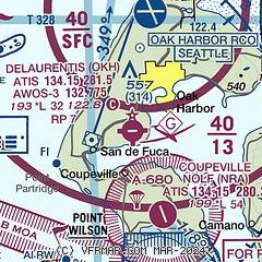
| Sectional chart |
|---|
|
| Airport distance calculator |
|---|
|
|
| Sunrise and sunset |
|---|
|
Times for 09-Jan-2026
| | Local
(UTC-8) | | Zulu
(UTC) |
|---|
| Morning civil twilight | | 07:25 | | 15:25 |
| Sunrise | | 08:01 | | 16:01 |
| Sunset | | 16:35 | | 00:35 |
| Evening civil twilight | | 17:11 | | 01:11 |
|
| Current date and time |
|---|
| Zulu (UTC) | 09-Jan-2026 10:12:54 |
|---|
| Local (UTC-8) | 09-Jan-2026 02:12:54 |
|---|
|
| METAR |
|---|
| KOKH | 090949Z AUTO 11003KT 10SM -DZ SCT044 OVC060 06/04 A3038 RMK AO2
|
KNRA
4nm S | 090946Z AUTO 16005KT 10SM OVC060 06/04 A3038 RMK AO2 RAB20E45 SLP229 T00560039 TSNO PNO $
|
KNUW
6nm N | 090953Z 12010KT 10SM -RA FEW010 BKN030 OVC070 06/04 A3037 RMK AO2 RAB50 SLP288 P0001 T00560044
|
K0S9
13nm SW | 090955Z AUTO 10004KT 10SM BKN039 OVC044 04/04 A3036 RMK AO2
|
KBVS
16nm NE | 090955Z AUTO 00000KT 10SM OVC015 05/05 A3039 RMK A01
|
|
| TAF |
|---|
KNUW
6nm N | 0907/1007 12010KT 9999 VCSH BKN015 OVC060 640309 641204 550307 QNH3032INS TEMPO 0907/0909 11010KT BKN005 BKN010 BECMG 0909/0911 13013G23KT 9999 SCT012 BKN060 BKN130 BKN250 620309 530005 550507 QNH3036INS TEMPO 0911/0917 14018G27KT 4800 BR BKN007 OVC015 FM091700 14015G25KT 9999 NSW SCT007 BKN015 OVC050 620509 530005 550509 QNH3042INS TX08/0923Z TN03/0914Z FS30241
|
|
| NOTAMs |
|---|
NOTAMs are issued by the DoD/FAA and will open in a separate window not controlled by AirNav.
|
|

