FAA INFORMATION EFFECTIVE 14 MAY 2026
Location
| FAA Identifier: | BVS |
| Lat/Long: | 48-28-13.8940N 122-25-18.0820W
48-28.231567N 122-25.301367W
48.4705261,-122.4216894
(estimated) |
| Elevation: | 145.1 ft. / 44.2 m (surveyed) |
| Variation: | 16E (2015) |
| From city: | 3 miles W of central business district of the associated city |
| Time zone: | UTC -7 (UTC -8 during Standard Time) |
| Zip code: | 98233 |
Airport Operations
| Airport use: | Open to the public |
| Activation date: | 12/1937 |
| Control tower: | no |
| ARTCC: | SEATTLE CENTER |
| FSS: | SEATTLE FLIGHT SERVICE STATION |
| NOTAMs facility: | BVS (NOTAM-D service available) |
| Attendance: | 0700-1900
TERMINAL BUILDING OPEN 0700-1900. AFTER HOURS, ACCESS AVAILABLE TO PILOTS. TERMINAL AND APRON ADJACENT TO TERMINAL FREE PILOT ACCESS WIFI. |
| Pattern altitude: | 645.1 ft. MSL
ULTRALIGHT TPA 500 FT AGL. |
| Wind indicator: | lighted |
| Segmented circle: | yes |
| Lights: | ACTVT MIRL RY 11/29, LIRL RY 04/22, PAPI RY 11 & 29, AND REIL RY 11 & 29 - CTAF. PAPI RYS 04 & 22 OPR CONTINUOUSLY. |
| Beacon: | white-green (lighted land airport)
Operates sunset to sunrise. |
| International operations: | customs landing rights airport |
Airport Communications
| CTAF/UNICOM: | 123.075 |
| WX AWOS-3: | 121.125 (360-757-7767) |
| WHIDBEY APPROACH: | 120.7 |
| WHIDBEY DEPARTURE: | 120.7 |
| WX ASOS at NUW (12 nm SW): | PHONE 360-257-8813 |
| WX AWOS-3 at OKH (17 nm SW): | 132.775 (360-675-8431) |
| WX ASOS at BLI (20 nm N): | PHONE 360-671-8688 |
Nearby radio navigation aids
| VOR radial/distance | | VOR name | | Freq | | Var |
|---|
| CVVr023/18.1 | | PENN COVE VOR/DME | | 117.20 | | 19E |
| PAEr330/33.5 | | PAINE VOR/DME | | 110.60 | | 20E |
| NDB name | | Hdg/Dist | | Freq | | Var | | ID |
|---|
| FRIDAY HARBOR | | 079/24.1 | | 284 | | 17E | | FHR | ..-. .... .-. |
Airport Services
| Fuel available: | 100LL JET-A |
| Parking: | tiedowns |
| Airframe service: | MAJOR |
| Powerplant service: | MAJOR |
| Bottled oxygen: | HIGH/LOW |
| Bulk oxygen: | NONE |
Runway Information
Runway 11/29
| Dimensions: | 5480 x 100 ft. / 1670 x 30 m |
| Surface: | asphalt, in excellent condition |
| Weight bearing capacity: | | Single wheel: | 60.0 | | Double wheel: | 75.0 | | Double tandem: | 125.0 |
|
| Runway edge lights: | medium intensity |
| RUNWAY 11 | | RUNWAY 29 |
| Latitude: | 48-28.670773N | | 48-28.135442N |
| Longitude: | 122-25.855780W | | 122-24.765573W |
| Elevation: | 145.1 ft. | | 103.2 ft. |
| Traffic pattern: | left | | left |
| Runway heading: | 110 magnetic, 126 true | | 290 magnetic, 306 true |
| Markings: | nonprecision, in fair condition | | nonprecision, in fair condition |
| Visual slope indicator: | 4-light PAPI on left (3.00 degrees glide path) | | 4-light PAPI on left (3.00 degrees glide path) |
| Runway end identifier lights: | yes | | yes |
| Touchdown point: | yes, no lights | | yes, no lights |
Runway 4/22
| Dimensions: | 3000 x 60 ft. / 914 x 18 m |
| Surface: | asphalt, in poor condition
WDSPR, OPN, UNSEALED CRACKS AND JOINTS. |
| Weight bearing capacity: | |
| Runway edge lights: | low intensity |
| Runway edge markings: | MARKINGS FADED. |
| RUNWAY 4 | | RUNWAY 22 |
| Latitude: | 48-27.781870N | | 48-28.054518N |
| Longitude: | 122-25.593545W | | 122-24.975303W |
| Elevation: | 84.0 ft. | | 93.9 ft. |
| Traffic pattern: | left | | left |
| Runway heading: | 040 magnetic, 056 true | | 220 magnetic, 236 true |
| Markings: | basic, in poor condition | | basic, in poor condition |
| Visual slope indicator: | 2-light PAPI on left (4.00 degrees glide path) | | 2-light PAPI on left (3.00 degrees glide path) |
| Touchdown point: | yes, no lights | | yes, no lights |
Airport Ownership and Management from official FAA records
| Ownership: | Publicly-owned |
| Owner: | PORT OF SKAGIT COUNTY
15400 AIRPORT DR, PO BOX 348
BURLINGTON, WA 98233
Phone 360-757-0011 |
| Manager: | KEITH D. LOVE
15400 AIRPORT DR, 15400 AIRPORT DR
BURLINGTON, WA 98233
Phone 360-757-0011 |
Additional Remarks
| - | FOR CD CTC WHIDBEY APCH AT 360-257-3310. |
| - | RWY 04/22 CLSD TO ACFT MORE THAN 12500 LB AND WINGSPAN MORE THAN 49 FT. |
| - | MIGRATORY WATERFOWL & BIRDS ON AND INVOF ARPT. |
| - | HELICOPTER TRAINING OPS ON AIRPORT W/ AUTOROTATIONS ON RUNWAY |
| - | USE OF TWY B BY ACFT WITH WINGSPAN 49 FT OR GREATER PROHIBITED WHEN RY 04/22 IN USE. |
| - | POSSIBLE TURBULENCE INVOF EXHAUST STACKS 3,500 FT SW OF RW 04, AVOID LOW ALT OVERFLT. |
| - | U.S. CUST SVC AVBL FOR INTL ARR. CHK PORT OF SKAGIT WEBSITE FOR REQ FOR SVC INSRT, WWW.PORTOFSKAGIT.COM. AVBL SEVEN DAYS A WEEK, PER APVL. USAGE FEES APPLY. |
Instrument Procedures
NOTE: All procedures below are presented as PDF files. If you need a reader for these files, you should download the free Adobe Reader.NOT FOR NAVIGATION. Please procure official charts for flight.
FAA instrument procedures published for use from 14 May 2026 at 0901Z to 11 June 2026 at 0900Z.
IAPs - Instrument Approach Procedures |
|---|
| RNAV (GPS) RWY 11 | |
download (348KB) |
| RNAV (GPS) RWY 29 | |
download (340KB) |
| NOTE: Special Alternate Minimums apply | |
download (175KB) |
| NOTE: Special Take-Off Minimums/Departure Procedures apply | |
download (336KB) |
Other nearby airports with instrument procedures:
KNUW - Whidbey Island Naval Air Station (Ault Field) Airport (12 nm SW)
KOKH - DeLaurentis Airport (17 nm SW)
KBLI - Bellingham International Airport (20 nm N)
KAWO - Arlington Municipal Airport (21 nm SE)
KORS - Orcas Island Airport (24 nm NW)
|
|

Road maps at:
MapQuest
Bing
Google
| Aerial photo |
|---|
WARNING: Photo may not be current or correct
 Photo by Martin W. Acuff
Photo taken 24-Jul-2010
Photo by Martin W. Acuff
Photo taken 24-Jul-2010
Do you have a better or more recent aerial photo of Skagit Regional Airport that you would like to share? If so, please send us your photo.
|
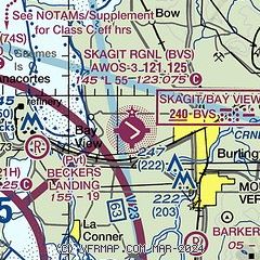
| Sectional chart |
|---|
|
CAUTION: Diagram may not be current

| Airport distance calculator |
|---|
|
|
| Sunrise and sunset |
|---|
|
Times for 03-Jun-2026
| | Local
(UTC-7) | | Zulu
(UTC) |
|---|
| Morning civil twilight | | 04:31 | | 11:31 |
| Sunrise | | 05:12 | | 12:12 |
| Sunset | | 21:04 | | 04:04 |
| Evening civil twilight | | 21:44 | | 04:44 |
|
| Current date and time |
|---|
| Zulu (UTC) | 04-Jun-2026 04:08:12 |
|---|
| Local (UTC-7) | 03-Jun-2026 21:08:12 |
|---|
|
| METAR |
|---|
| KBVS | 040355Z AUTO 00000KT 10SM FEW055 BKN080 OVC085 15/09 A3008 RMK A01
|
KNUW
12nm SW | 040353Z VRB03KT 10SM FEW040 BKN095 BKN160 BKN230 13/07 A3008 RMK AO2 SLP190 T01330072
|
KOKH
17nm SW | 040259Z AUTO 24005KT 10SM SCT100 14/07 A3008 RMK AO2
|
KNRA
19nm SW | 040346Z AUTO 26010KT 1SM HZ BKN080 12/06 A3009 RMK AO2 VIS 1/2V3 SLP134 T01220061 TSNO $
|
|
| TAF |
|---|
KNUW
12nm SW | 022300Z 0223/0323 VRB06KT 9999 FEW100 SCT210 SCT250 QNH2989INS TEMPO 0301/0307 26008KT FM031000 21007KT 9999 VCSH SCT060 BKN090 BKN150 OVC220 QNH2990INS TX23/0300Z TN11/0313Z COR 0315 FS30046
|
|
| NOTAMs |
|---|
NOTAMs are issued by the DoD/FAA and will open in a separate window not controlled by AirNav.
|
|


