FAA INFORMATION EFFECTIVE 09 JULY 2026
Location
| FAA Identifier: | BLI |
| Lat/Long: | 48-47-33.7000N 122-32-15.1000W
48-47.561667N 122-32.251667W
48.7926944,-122.5375278
(estimated) |
| Elevation: | 171 ft. / 52.1 m (surveyed) |
| Variation: | 16E (2020) |
| From city: | 3 miles NW of BELLINGHAM, WA |
| Time zone: | UTC -7 (UTC -8 during Standard Time) |
| Zip code: | 98226 |
Airport Operations
| Airport use: | Open to the public |
| Activation date: | 11/1938 |
| Control tower: | yes |
| ARTCC: | VANCOUVER CENTER |
| FSS: | SEATTLE FLIGHT SERVICE STATION |
| NOTAMs facility: | BLI (NOTAM-D service available) |
| Attendance: | CONTINUOUS |
| Pattern altitude: | 1201 ft. MSL
TPA 1030 FT AGL FIXED WING; 530 FT AGL HELICOPTER; 1830 FT AGL TURBO. |
| Wind indicator: | lighted |
| Segmented circle: | yes |
| Lights: | WHEN ATCT CLSD ACTVT MALSR RWY 16; REIL RWY 34; HIRL RWY 16/34 - CTAF. |
| Beacon: | white-green (lighted land airport)
Operates sunset to sunrise. |
| Landing fee: | yes, OVR 7500 LB. |
| Fire and rescue: | ARFF index B |
| Airline operations: | PPR FOR UNSKED ACR OPS GTR THAN 30 PAX SEATS - 360-739-1944. |
| International operations: | international airport of entry |
Airport Communications
| CTAF: | 124.9 |
| UNICOM: | 122.95 |
| ATIS: | 134.45 |
| WX ASOS: | PHONE 360-671-8688 |
| BELLINGHAM GROUND: | 127.4 379.3 [0700-2230] |
| BELLINGHAM TOWER: | 124.9 379.3 [0700-2230] |
| VICTORIA TERMINAL APPROACH: | 132.7 |
| VICTORIA TERMINAL DEPARTURE: | 132.7 |
| MADEE RNAV STAR: | 118.2 ;WEST 120.7 ;EAST |
| WX AWOS-3P at ORS (16 nm W): | 135.425 (360-376-6045) |
| WX AWOS-3 at BVS (20 nm S): | 121.125 (360-757-7767) |
- APCH/DEP SVC PRVDD BY VICTORIA TRML (YYJ) ON FREQ 132.7.
Nearby radio navigation aids
| VOR radial/distance | | VOR name | | Freq | | Var |
|---|
| YVRr108/29.5 | | VANCOUVER VOR/DME | | 115.90 | | 17E |
| CVVr354/33.7 | | PENN COVE VOR/DME | | 117.20 | | 19E |
| YYJr067/37.7 | | VICTORIA VOR/DME | | 113.70 | | 17E |
| NDB name | | Hdg/Dist | | Freq | | Var | | ID |
|---|
| FRIDAY HARBOR | | 032/25.6 | | 284 | | 17E | | FHR | ..-. .... .-. |
Airport Services
| Fuel available: | 100LL JET-A |
| Parking: | tiedowns |
| Airframe service: | NONE |
| Powerplant service: | MAJOR |
Runway Information
Runway 16/34
| Dimensions: | 6700 x 150 ft. / 2042 x 46 m |
| Surface: | asphalt/grooved, in good condition |
| Weight bearing capacity: | | Single wheel: | 75.0 | | Double wheel: | 160.0 | | Double tandem: | 250.0 |
|
| Runway edge lights: | high intensity |
| RUNWAY 16 | | RUNWAY 34 |
| Latitude: | 48-48.112382N | | 48-47.010565N |
| Longitude: | 122-32.253402W | | 122-32.248807W |
| Elevation: | 163.4 ft. | | 171.0 ft. |
| Traffic pattern: | right | | left |
| Runway heading: | 164 magnetic, 180 true | | 344 magnetic, 360 true |
| Declared distances: | TORA:6700 TODA:6700 ASDA:6700 LDA:6700 | | TORA:6700 TODA:6700 ASDA:6700 LDA:6700 |
| Markings: | precision, in good condition | | nonprecision, in good condition |
| Visual slope indicator: | 4-light PAPI on left (3.00 degrees glide path) | | 4-light PAPI on left (3.00 degrees glide path) |
| RVR equipment: | touchdown | | rollout |
| Approach lights: | MALSR: 1,400 foot medium intensity approach lighting system with runway alignment indicator lights | | |
| Runway end identifier lights: | no | | yes |
| Touchdown point: | yes, no lights | | yes, no lights |
| Instrument approach: | ILS/DME | | |
Airport Ownership and Management from official FAA records
| Ownership: | Publicly-owned |
| Owner: | PORT OF BELLINGHAM
1801 ROEDER AVE
BELLINGHAM, WA 98227
Phone 360-676-2500 |
| Manager: | MATT RODRIGUEZ
4255 MITCHELL WAY, SUITE 206
BELLINGHAM, WA 98226
Phone 360-676-2500 |
Additional Remarks
| A39-16/34 | PCR VALUE: 739/F/D/X/T |
| - | BIRDS & WILDLIFE ON & INVOF ARPT. |
| - | COML RAMP CLSD TO PVT ACFT. |
| - | ACR OPS USE TWY A, TWY B, TWY C, TWY D WEST OF TWY E, TWY E, TWY F WEST OF TWY A, TWY G & TWY H. |
| - | FLIGHT NOTIFICATION SERVICE (ADCUS) AVBL. |
| - | FOR CD WHEN ATCT IS CLSD, CTC VICTORIA TRML ON 132.7 OR AT 604-586-4561. |
| - | TWY A BTN TWY E & F CLSD TO WINGSPAN GTR THAN 118FT. PORTIONS OF TWY A AT TWY G & J NOT VIS FM ATCT. |
| - | NOISE ABATEMENT PROC IN EFCT - 360-739-1944. |
Instrument Procedures
NOTE: All procedures below are presented as PDF files. If you need a reader for these files, you should download the free Adobe Reader.NOT FOR NAVIGATION. Please procure official charts for flight.
FAA instrument procedures published for use from 09 July 2026 at 0901Z to 06 August 2026 at 0900Z.
STARs - Standard Terminal Arrivals |
|---|
| MADEE SEVEN (RNAV) **NEW** | |
download (278KB) |
IAPs - Instrument Approach Procedures |
|---|
| ILS OR LOC RWY 16 | |
download (230KB) |
| ILS RWY 16 (SA CAT I) | |
download (207KB) |
| RNAV (RNP) Z RWY 16 | |
download (186KB) |
| RNAV (RNP) Z RWY 34 | |
download (204KB) |
| RNAV (GPS) Y RWY 16 | |
download (186KB) |
| RNAV (GPS) Y RWY 34 | |
download (212KB) |
| NOTE: Special Alternate Minimums apply | |
download (211KB) |
Departure Procedures |
|---|
| KLSHN TWO (RNAV) | |
download (170KB) |
|
|---|
| BELLINGHAM ONE (OBSTACLE) (RNAV) | |
download (330KB) |
| NOTE: Special Take-Off Minimums/Departure Procedures apply | |
download (548KB) |
Other nearby airports with instrument procedures:
KORS - Orcas Island Airport (16 nm W)
KBVS - Skagit Regional Airport (20 nm S)
KFHR - Friday Harbor Airport (25 nm SW)
KNUW - Whidbey Island Naval Air Station (Ault Field) Airport (27 nm S)
KOKH - DeLaurentis Airport (33 nm S)
|
|

Road maps at:
MapQuest
Bing
Google
| Aerial photo |
|---|
WARNING: Photo may not be current or correct
 Taken in April 2008
Do you have a better or more recent aerial photo of Bellingham International Airport that you would like to share? If so, please send us your photo.
|
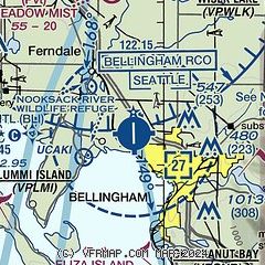
| Sectional chart |
|---|
|
CAUTION: Diagram may not be current
 Download PDF
of official airport diagram from the FAA
| Airport distance calculator |
|---|
|
|
| Sunrise and sunset |
|---|
|
Times for 19-Jul-2026
| | Local
(UTC-7) | | Zulu
(UTC) |
|---|
| Morning civil twilight | | 04:49 | | 11:49 |
| Sunrise | | 05:29 | | 12:29 |
| Sunset | | 21:04 | | 04:04 |
| Evening civil twilight | | 21:44 | | 04:44 |
|
| Current date and time |
|---|
| Zulu (UTC) | 19-Jul-2026 07:16:07 |
|---|
| Local (UTC-7) | 19-Jul-2026 00:16:07 |
|---|
|
| METAR |
|---|
| KBLI | 190653Z AUTO 20004KT 10SM FEW050 15/13 A3011 RMK AO2 SLP203 T01500128
|
KORS
15nm W | 190655Z AUTO 15003KT 10SM CLR 15/12 A3012 RMK AO2
|
CYXX
16nm NE | 190600Z 24003KT 15SM SKC 16/12 A3011 RMK SLP198
|
CWWK
16nm NW | 190600Z AUTO 00000KT 16/12 RMK AO1 SLP200 T01590119 55002
|
CWEZ
20nm W | 190600Z AUTO 21001KT 16/11 RMK AO1 SLP200 T01600112 56003
|
|
| TAF |
|---|
| KBLI | 190525Z 1906/2006 19005KT P6SM SKC FM191100 VRB03KT P6SM BKN030 FM191700 29005KT P6SM SCT030 FM191900 26007KT P6SM SCT250
|
CYXX
16nm NE | 190540Z 1906/2006 11005KT P6SM FEW050 FM191200 VRB03KT P6SM SCT012 TEMPO 1912/1918 FEW006 BKN012 PROB30 1912/1916 BKN006 FM191800 22005KT P6SM FEW050 BECMG 1919/1921 23008KT RMK NXT FCST BY 191200Z
|
|
| NOTAMs |
|---|
NOTAMs are issued by the DoD/FAA and will open in a separate window not controlled by AirNav.
|
|


