FAA INFORMATION EFFECTIVE 14 MAY 2026
Location
| FAA Identifier: | FHR |
| Lat/Long: | 48-31-19.1000N 123-01-27.7000W
48-31.318333N 123-01.461667W
48.5219722,-123.0243611
(estimated) |
| Elevation: | 112.7 ft. / 34.4 m (surveyed) |
| Variation: | 16E (2015) |
| Time zone: | UTC -7 (UTC -8 during Standard Time) |
| Zip code: | 98250 |
Airport Operations
| Airport use: | Open to the public |
| Activation date: | 03/1939 |
| Control tower: | no |
| ARTCC: | SEATTLE CENTER |
| FSS: | SEATTLE FLIGHT SERVICE STATION |
| NOTAMs facility: | FHR (NOTAM-D service available) |
| Attendance: | MON-FRI 0800-1700
NO ATTENDANCE DURING HOLIDAYS. |
| Wind indicator: | lighted |
| Segmented circle: | yes |
| Lights: | ACTVT REIL RWY 16 & 34; PAPI RWY 16 & 34; MIRL RWY 16/34 - CTAF. |
| Beacon: | white-green (lighted land airport)
Operates sunset to sunrise. |
| Landing fee: | yes, ACFT IN EXCESS OF 7,500 LBS CHARGED FEE BASED ON WEIGHT - CTC ARPT MGR FOR INFO. |
| International operations: | international airport of entry
LNDG FEES CHARGED FOR AIRLINES AND CHARTERS. |
Airport Communications
| CTAF: | 128.25 |
| WX ASOS: | 135.675 (360-378-8491) |
| WHIDBEY APPROACH: | 118.2 |
| WHIDBEY DEPARTURE: | 118.2 |
| WX AWOS-3P at S31 (4 nm SE): | 118.525 (360-376-2071) |
| WX AWOS-3P at ORS (12 nm N): | 135.425 (360-376-6045) |
| WX ASOS at NUW (18 nm SE): | PHONE 360-257-8813 |
Nearby radio navigation aids
| VOR radial/distance | | VOR name | | Freq | | Var |
|---|
| CVVr305/20.5 | | PENN COVE VOR/DME | | 117.20 | | 19E |
| YYJr107/22.0 | | VICTORIA VOR/DME | | 113.70 | | 17E |
| YVRr155/33.7 | | VANCOUVER VOR/DME | | 115.90 | | 17E |
| NDB name | | Hdg/Dist | | Freq | | Var | | ID |
|---|
| FRIDAY HARBOR | | at field | | 284 | | 17E | | FHR | ..-. .... .-. |
Airport Services
| Fuel available: | 100LL |
| Parking: | tiedowns |
| Airframe service: | MAJOR |
| Powerplant service: | MAJOR |
| Bottled oxygen: | NONE |
| Bulk oxygen: | NONE |
Runway Information
Runway 16/34
| Dimensions: | 3402 x 75 ft. / 1037 x 23 m |
| Surface: | asphalt/grooved, in good condition |
| Weight bearing capacity: | |
| Runway edge lights: | medium intensity |
| RUNWAY 16 | | RUNWAY 34 |
| Latitude: | 48-31.597325N | | 48-31.038600N |
| Longitude: | 123-01.483882W | | 123-01.440532W |
| Elevation: | 112.7 ft. | | 83.9 ft. |
| Traffic pattern: | right | | right |
| Runway heading: | 161 magnetic, 177 true | | 341 magnetic, 357 true |
| Markings: | basic, in good condition | | nonprecision, in good condition |
| Visual slope indicator: | 2-light PAPI on right (4.00 degrees glide path)
PAPI UNUSBL BYD 3 DEGS RIGHT OF CNTRLN | | 4-light PAPI on right (3.50 degrees glide path) |
| Runway end identifier lights: | yes | | yes |
| Touchdown point: | yes, no lights | | yes, no lights |
| Obstructions: | 32 ft. bldg, 904 ft. from runway, 126 ft. left of centerline, 22:1 slope to clear | | 70 ft. trees, 2650 ft. from runway, 34:1 slope to clear |
Airport Ownership and Management from official FAA records
| Ownership: | Publicly-owned |
| Owner: | PORT OF FRIDAY HARBOR
PO BOX 889
FRIDAY HARBOR, WA 98250
Phone (360) 378-2688 |
| Manager: | MIKE OTIS
PO BOX 889
FRIDAY HARBOR, WA 98250
Phone (360) 378-4724
CELL:360-317-8674 |
Additional Remarks
| - | CUSTOMS APRON LOCATED ON EAST SIDE OF TERMINAL RAMP. |
| - | FOR CD CTC WHIDBEY APCH AT 360-257-3310. |
| - | TSNT TURBINE ACFT PRKG LESS THAN 1 HR DURN LCTD 250 FT S OF TRML RAMP. |
| - | FOR NOISE ABATEMENT AVOID TKOFS BTN 2200-0700. |
| - | NOISE ABATEMENT PROCS IN EFFECT CTC AMGR 360-378-4724. |
| - | SOFT GROUND BETWEEN TIE-DOWNS NE PARKING AREA. |
| - | PREFERRED RY 16 IN CALM WIND CONDITIONS. |
| - | DUE TO HIGH CONCENTRATION OF TFC INVOF ARPT RECOMMEND LDG LGTS OR FORWARD VISIBILITY LGTS TURNED ON WHILE UTILIZING ARPT. |
| - | ACFT WITH WINGSPAN GREATER THAN 55 FT, 24 HR PPR. CTC ARPT MGR 360-378-4724 OR CELL 360-317-8674. |
| - | 128.25 MONITORED INTMTLY. |
| - | BIRD ACTIVITY ON AND INVOF ARPT. |
Instrument Procedures
NOTE: All procedures below are presented as PDF files. If you need a reader for these files, you should download the free Adobe Reader.NOT FOR NAVIGATION. Please procure official charts for flight.
FAA instrument procedures published for use from 14 May 2026 at 0901Z to 11 June 2026 at 0900Z.
IAPs - Instrument Approach Procedures |
|---|
| RNAV (GPS) RWY 34 | |
download (294KB) |
| NDB RWY 34 | |
download (190KB) |
| NOTE: Special Alternate Minimums apply | |
download (56KB) |
| NOTE: Special Take-Off Minimums/Departure Procedures apply | |
download (339KB) |
Other nearby airports with instrument procedures:
KORS - Orcas Island Airport (12 nm N)
KNUW - Whidbey Island Naval Air Station (Ault Field) Airport (18 nm SE)
KOKH - DeLaurentis Airport (21 nm SE)
KBVS - Skagit Regional Airport (24 nm E)
KBLI - Bellingham International Airport (25 nm NE)
|
|

Road maps at:
MapQuest
Bing
Google
| Aerial photo |
|---|
WARNING: Photo may not be current or correct
 Photo by Trent Thomas
Photo taken 29-Mar-2021
facing north, approx 600'
Photo by Trent Thomas
Photo taken 29-Mar-2021
facing north, approx 600'
Do you have a better or more recent aerial photo of Friday Harbor Airport that you would like to share? If so, please send us your photo.
|
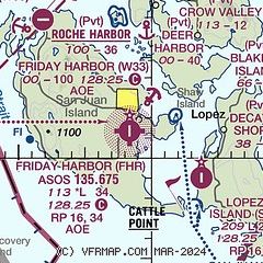
| Sectional chart |
|---|
|
| Airport distance calculator |
|---|
|
|
| Sunrise and sunset |
|---|
|
Times for 06-Jun-2026
| | Local
(UTC-7) | | Zulu
(UTC) |
|---|
| Morning civil twilight | | 04:31 | | 11:31 |
| Sunrise | | 05:13 | | 12:13 |
| Sunset | | 21:09 | | 04:09 |
| Evening civil twilight | | 21:50 | | 04:50 |
|
| Current date and time |
|---|
| Zulu (UTC) | 06-Jun-2026 11:50:24 |
|---|
| Local (UTC-7) | 06-Jun-2026 04:50:24 |
|---|
|
| METAR |
|---|
| KFHR | 061053Z AUTO 18004KT 8SM -RA BKN048 OVC060 09/08 A2991 RMK AO2 RAB45 SLP128 P0002 T00890083
|
CWZO
8nm W | 061100Z AUTO 14010KT RMK AO1
|
CWYJ
11nm SW | 061100Z AUTO 00000KT 08/07 RMK AO1 SLP120 T00830069 58001
|
KORS
12nm NE | 060915Z AUTO 17005KT 10SM FEW050 FEW085 SCT110 10/09 A2991 RMK AO2
|
CWLM
13nm SW | 061100Z AUTO 19005KT 09/07 RMK AO1 6001 SLP117 T00850073 50004
|
CYWH
13nm SW | 060400Z 27011G20KT 15SM FEW030 SCT075 BKN090 12/06 A2990 RMK SC1AC3AC3 LAST STFD OBS/NXT 061300Z SLP127
|
CWEZ
15nm N | 060800Z AUTO 19003KT 11/06 RMK AO1 SLP127 T01070064 50000
|
CWPF
17nm W | 061130Z AUTO 17005KT 10/07 RMK AO1 SLP123 T00950068 56001
|
CYYJ
18nm NW | 061100Z 00000KT 30SM SCT056 BKN091 10/06 A2988 RMK SC4AC2 SLP120
|
KNUW
18nm SE | 061053Z 12005KT 10SM SCT025 BKN040 BKN065 09/08 A2990 RMK SLP130 P0001 T00890083
|
|
| TAF |
|---|
CYWH
13nm SW | 052040Z 0521/0604 22010KT P6SM SCT030 BKN080 TEMPO 0521/0604 P6SM -SHRA BKN030 BECMG 0521/0523 24012G22KT RMK NXT FCST BY 061400Z
|
CYYJ
18nm NW | 060540Z 0606/0706 24008KT P6SM SCT040 SCT080 BKN150 TEMPO 0606/0609 5SM -SHRA BR BKN030 BKN080 BECMG 0606/0608 21006KT FM060900 21006KT P6SM SCT020 BKN040 TEMPO 0609/0703 5SM -SHRA BR BKN020 BECMG 0616/0618 14008KT FM070300 VRB03KT P6SM SCT040 SCT080 TEMPO 0703/0706 5SM -SHRA BR BKN030 RMK NXT FCST BY 061200Z
|
KNUW
18nm SE | 060700Z 0607/0707 VRB06KT 6000 -SHRA BKN030 OVC055 640509 531009 QNH2988INS TEMPO 0607/0609 3200 +SHRA BR BKN020CB OVC035 BECMG 0609/0611 VRB06KT 9999 -SHRA SCT020 BKN045CB BKN065 BKN250 640509 531009 QNH2989INS TEMPO 0614/0620 12007KT 3200 +SHRA BR BKN015CB OVC040 FM062000 27008KT 9999 -SHRA SCT025 BKN050 BKN090 BKN250 620509 531009 QNH2991INS TEMPO 0620/0702 VRB20G30KT 3200 +TSRA BR BKN025CB OVC045 FM070200 25018G25KT 9999 -SHRA SCT025 OVC050 QNH2994INS TX14/0623Z TN07/0613Z FS30232
|
|
| NOTAMs |
|---|
NOTAMs are issued by the DoD/FAA and will open in a separate window not controlled by AirNav.
|
|

